Property Record
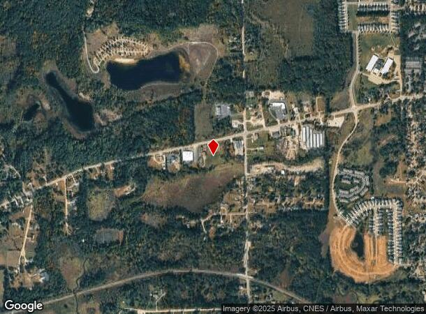
2470 Grange Hall Rd, Fenton, MI 48430
NEARBY LISTINGS FOR SALE OR LEASE
-
-
View all Fenton listings for sale on LoopNet.com
Property Detail
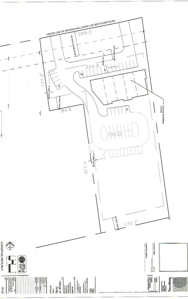
2470 Grange Hall Rd
01-29-427-004
T5N, R7E, SEC 29 PART OF SE 1/4 BEG AT PT DIST S 530.35 FT & S 77-44-45 W 319.43 FT FROM E 1/4 COR, TH S 07-22-50 E 490.62 FT, TH S 77-34-00 W 543.11 FT, TH N 513.32 FT TO CEN OF HWY, TH N 79-15-30 E 419.87 FT, TH N 77-44-45 E 56.12 FT TO BEG 5.79 A
Storebuilding
Oakland
A
Michigan
26049C0445D
5.79 AC
2024
St Clair & Lapeer Counties
2024
Detroit
124000
Detroit-Warren-Dearborn, MI
3,600 SF
DEMOGRAPHICS near 2470 Grange Hall Rd
1 Mile
3 Mile
5 Mile
2024 Total Population
3,681
17,331
37,244
2029 Population
3,703
17,320
37,064
Pop Growth 2024-2029
+ 0.60%
(0.06%)
(0.48%)
Average Age
39
41
42
2024 Total Households
1,417
6,944
15,222
HH Growth 2024-2029
+ 0.49%
(0.10%)
(0.57%)
Median Household Inc
$76,918
$67,654
$77,128
Avg Household Size
2.60
2.40
2.40
2024 Avg HH Vehicles
2.00
2.00
2.00
Median Home Value
$234,600
$214,469
$249,719
Median Year Built
1986
1986
1984
Nearby Places
Map Layers
Map Styles
 Street
 Aerial
- Restaurants
- Banks
- Shops
- Fitness
- Groceries
PUBLIC TRANSPORTATION
AIRPORT
Bishop International
DRIVE
WALK
Distance
Bishop International
32 min
17.8 mi
Freight Ports
Port of Toledo
DRIVE
WALK
Distance
Port of Toledo
124 min
101.9 mi
Nearby Properties
Address
Land Use
TOTAL SIZE
Lot Size
Zoning
Address
Land Use
TOTAL SIZE
Lot Size
Zoning
70,522 SF
23.58 AC
SEVERAL
Address
Land Use
TOTAL SIZE
Lot Size
Zoning
41,427 SF
0.41 AC
CBD
Address
Land Use
TOTAL SIZE
Lot Size
Zoning
92,658 SF
10.29 AC
Address
Land Use
TOTAL SIZE
Lot Size
Zoning
94,597 SF
9.10 AC
NO DATA TO
Address
Land Use
TOTAL SIZE
Lot Size
Zoning
49,541 SF
Address
Land Use
TOTAL SIZE
Lot Size
Zoning
122,136 SF
22 AC
Address
Land Use
TOTAL SIZE
Lot Size
Zoning
67.37 AC
Address
Land Use
TOTAL SIZE
Lot Size
Zoning
66,825 SF
4.57 AC
Address
Land Use
TOTAL SIZE
Lot Size
Zoning
39.28 AC
Address
Land Use
TOTAL SIZE
Lot Size
Zoning
21,986 SF
2.28 AC
GBD
Address
Land Use
TOTAL SIZE
Lot Size
Zoning
15,180 SF
0.64 AC
CBD
Address
Land Use
TOTAL SIZE
Lot Size
Zoning
10,715 SF
1.18 AC
CBD
Address
Land Use
TOTAL SIZE
Lot Size
Zoning
140 AC
AGRE
Address
Land Use
TOTAL SIZE
Lot Size
Zoning
47,000 SF
5.16 AC
C2
Address
Land Use
TOTAL SIZE
Lot Size
Zoning
8,500 SF
0.20 AC
CBD
Address
Land Use
TOTAL SIZE
Lot Size
Zoning
8,405 SF
0.34 AC
CBD
Address
Land Use
TOTAL SIZE
Lot Size
Zoning
8,405 SF
0.34 AC
CBD
Address
Land Use
TOTAL SIZE
Lot Size
Zoning
14,532 SF
0.41 AC
NO DATA TO
Address
Land Use
TOTAL SIZE
Lot Size
Zoning
24,473 SF
28.16 AC
Address
Land Use
TOTAL SIZE
Lot Size
Zoning
45,679 SF
8.64 AC
Address
Land Use
TOTAL SIZE
Lot Size
Zoning
8,405 SF
0.34 AC
CBD
Address
Land Use
TOTAL SIZE
Lot Size
Zoning
4,228 SF
0.54 AC
NO DATA TO
Address
Land Use
TOTAL SIZE
Lot Size
Zoning
6,689 SF
1.15 AC
CBD
Address
Land Use
TOTAL SIZE
Lot Size
Zoning
8,289 SF
7.60 AC
Address
Land Use
TOTAL SIZE
Lot Size
Zoning
16,000 SF
1.38 AC
SEVERAL
Address
Land Use
TOTAL SIZE
Lot Size
Zoning
58,360 SF
1.17 AC
Address
Land Use
TOTAL SIZE
Lot Size
Zoning
19,225 SF
2.77 AC
C2
Address
Land Use
TOTAL SIZE
Lot Size
Zoning
12,792 SF
1.22 AC
GBD
Address
Land Use
TOTAL SIZE
Lot Size
Zoning
15,130 SF
1.93 AC
CBD
The World's #1 Commercial Real Estate Marketplace
Connect with us
© 2025 CoStar Group
The information above has been obtained from sources believed reliable. While we do not doubt its accuracy we have not verified it and make no guarantee, warranty or representation about it. It is your responsibility to independently confirm its accuracy and completeness. Any projections, opinions, assumptions, or estimates used are for example only and do not represent the current or future performance of the property. The value of this transaction to you depends on tax and other factors which should be evaluated by your tax, financial, and legal advisors. You and your advisors should conduct a careful, independent investigation of the property to determine to your satisfaction the suitability of the property for your needs.