Property Record
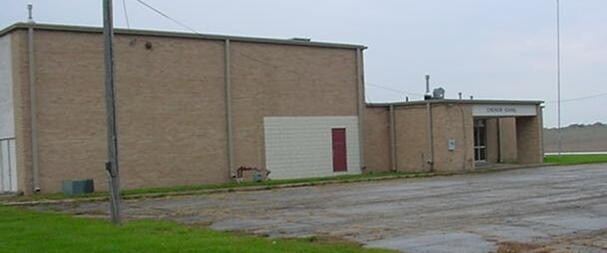
24711 Emerson Rd, Sterling, IL 61081

NEARBY LISTINGS FOR SALE OR LEASE
-
-
View all Sterling listings for sale on LoopNet.com
Property Detail
24711 Emerson Rd
1014451008
PT W1/2 S1/2 SE SEC 14 TWP 21 RNG 6
Commercialnec
Whiteside
X
Illinois
17195C0225E
3.93 AC
2024
Other Market Areas
2024
Sterling, IL
000100
DEMOGRAPHICS near 24711 Emerson Rd
1 Mile
3 Mile
5 Mile
2024 Total Population
179
2,925
25,019
2029 Population
169
2,837
24,692
Pop Growth 2024-2029
(5.59%)
(3.01%)
(1.31%)
Average Age
45
45
42
2024 Total Households
72
1,236
10,763
HH Growth 2024-2029
(5.56%)
(2.91%)
(1.31%)
Median Household Inc
$88,815
$59,724
$51,364
Avg Household Size
2.40
2.30
2.30
2024 Avg HH Vehicles
3.00
2.00
2.00
Median Home Value
$190,384
$157,668
$85,858
Median Year Built
1970
1967
1958
Nearby Places
Map Layers
Map Styles
 Street
 Aerial
- Restaurants
- Banks
- Shops
- Fitness
- Groceries
Nearby Properties
Address
Land Use
TOTAL SIZE
Lot Size
Zoning
Address
Land Use
TOTAL SIZE
Lot Size
Zoning
27.04 AC
Address
Land Use
TOTAL SIZE
Lot Size
Zoning
142.56 AC
Address
Land Use
TOTAL SIZE
Lot Size
Zoning
12.60 AC
Address
Land Use
TOTAL SIZE
Lot Size
Zoning
10.93 AC
Address
Land Use
TOTAL SIZE
Lot Size
Zoning
15.53 AC
Address
Land Use
TOTAL SIZE
Lot Size
Zoning
89,356 SF
13.16 AC
Address
Land Use
TOTAL SIZE
Lot Size
Zoning
6.87 AC
Address
Land Use
TOTAL SIZE
Lot Size
Zoning
21.12 AC
Address
Land Use
TOTAL SIZE
Lot Size
Zoning
6.01 AC
Address
Land Use
TOTAL SIZE
Lot Size
Zoning
53.31 AC
Address
Land Use
TOTAL SIZE
Lot Size
Zoning
31.04 AC
Address
Land Use
TOTAL SIZE
Lot Size
Zoning
3.95 AC
Address
Land Use
TOTAL SIZE
Lot Size
Zoning
9.01 AC
Address
Land Use
TOTAL SIZE
Lot Size
Zoning
1.78 AC
Address
Land Use
TOTAL SIZE
Lot Size
Zoning
5.97 AC
Address
Land Use
TOTAL SIZE
Lot Size
Zoning
150.96 AC
Address
Land Use
TOTAL SIZE
Lot Size
Zoning
7.46 AC
Address
Land Use
TOTAL SIZE
Lot Size
Zoning
8.04 AC
Address
Land Use
TOTAL SIZE
Lot Size
Zoning
Address
Land Use
TOTAL SIZE
Lot Size
Zoning
6.94 AC
Address
Land Use
TOTAL SIZE
Lot Size
Zoning
4.50 AC
Address
Land Use
TOTAL SIZE
Lot Size
Zoning
0.08 AC
Address
Land Use
TOTAL SIZE
Lot Size
Zoning
1.02 AC
Address
Land Use
TOTAL SIZE
Lot Size
Zoning
9.12 AC
Address
Land Use
TOTAL SIZE
Lot Size
Zoning
153.02 AC
Address
Land Use
TOTAL SIZE
Lot Size
Zoning
Address
Land Use
TOTAL SIZE
Lot Size
Zoning
18.48 AC
Address
Land Use
TOTAL SIZE
Lot Size
Zoning
2.56 AC
Address
Land Use
TOTAL SIZE
Lot Size
Zoning
1.47 AC
Address
Land Use
TOTAL SIZE
Lot Size
Zoning
1.93 AC
The World's #1 Commercial Real Estate Marketplace
Connect with us
© 2025 CoStar Group
The information above has been obtained from sources believed reliable. While we do not doubt its accuracy we have not verified it and make no guarantee, warranty or representation about it. It is your responsibility to independently confirm its accuracy and completeness. Any projections, opinions, assumptions, or estimates used are for example only and do not represent the current or future performance of the property. The value of this transaction to you depends on tax and other factors which should be evaluated by your tax, financial, and legal advisors. You and your advisors should conduct a careful, independent investigation of the property to determine to your satisfaction the suitability of the property for your needs.