Property Record
24719 W Port Rd, Harlingen, TX 78550
NEARBY LISTINGS FOR SALE OR LEASE
Property Detail
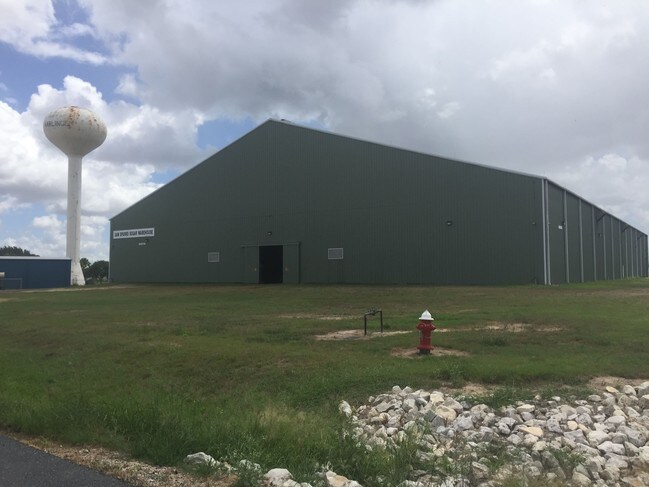
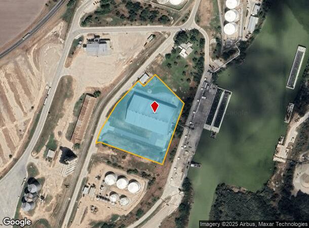
24719 W Port Rd
988360-0000-015000
Williams E M L Survey #276
Industrialgeneral
WILLIAMS E M L SURVEY #276 5.00 ACRES OUT OF 218.45 ACRES SURVEYS 276 & 302 (LEASE HOLD INT. SAMS SPARKS WHSE PT HARLINGEN LAND))
X
Cameron
48061C0300F
Texas
2024
5 AC
2025
Outlying Cameron County
010700
Brownsville/Harlingen
60,000 SF
Brownsville-Harlingen, TX
DEMOGRAPHICS near 24719 W Port Rd
1 Mile
3 Mile
5 Mile
2024 Total Population
118
4,309
35,265
2029 Population
125
4,325
36,071
Pop Growth 2024-2029
+ 5.93%
+ 0.37%
+ 2.29%
Average Age
37
38
37
2024 Total Households
33
1,334
12,071
HH Growth 2024-2029
+ 3.03%
+ 0.22%
+ 2.22%
Median Household Inc
$53,750
$53,365
$52,618
Avg Household Size
3.40
3.10
2.80
2024 Avg HH Vehicles
2.00
2.00
2.00
Median Home Value
$72,222
$124,129
$110,562
Median Year Built
1993
1993
1987
Nearby Places
Map Layers
Map Styles
 Street
 Aerial
- Restaurants
- Banks
- Shops
- Fitness
- Groceries
PUBLIC TRANSPORTATION
AIRPORT
Valley International
DRIVE
WALK
Distance
Valley International
15 min
5.0 mi
Brownsville/South Padre Island International
DRIVE
WALK
Distance
Brownsville/South Padre Island International
43 min
27.8 mi
Nearby Properties
Address
Land Use
TOTAL SIZE
Lot Size
Zoning
Address
Land Use
TOTAL SIZE
Lot Size
Zoning
663,572 SF
60.74 AC
I
Address
Land Use
TOTAL SIZE
Lot Size
Zoning
98,014 SF
40 AC
Address
Land Use
TOTAL SIZE
Lot Size
Zoning
188,102 SF
45.81 AC
C
Address
Land Use
TOTAL SIZE
Lot Size
Zoning
105,000 SF
9.15 AC
C
Address
Land Use
TOTAL SIZE
Lot Size
Zoning
88,964 SF
4.38 AC
I
Address
Land Use
TOTAL SIZE
Lot Size
Zoning
68,901 SF
5.49 AC
C
Address
Land Use
TOTAL SIZE
Lot Size
Zoning
80,000 SF
19.63 AC
C
Address
Land Use
TOTAL SIZE
Lot Size
Zoning
55,660 SF
13.71 AC
C
Address
Land Use
TOTAL SIZE
Lot Size
Zoning
73,655 SF
8.83 AC
Address
Land Use
TOTAL SIZE
Lot Size
Zoning
65,088 SF
4.20 AC
C
Address
Land Use
TOTAL SIZE
Lot Size
Zoning
50,128 SF
10 AC
Address
Land Use
TOTAL SIZE
Lot Size
Zoning
43,032 SF
16.56 AC
I
Address
Land Use
TOTAL SIZE
Lot Size
Zoning
63,000 SF
6.38 AC
I
Address
Land Use
TOTAL SIZE
Lot Size
Zoning
60,194 SF
23.95 AC
Address
Land Use
TOTAL SIZE
Lot Size
Zoning
4,948 SF
0.34 AC
C
Address
Land Use
TOTAL SIZE
Lot Size
Zoning
6,335 SF
11.87 AC
A-C
Address
Land Use
TOTAL SIZE
Lot Size
Zoning
31,840 SF
8.18 AC
Address
Land Use
TOTAL SIZE
Lot Size
Zoning
51,346 SF
6.84 AC
C
Address
Land Use
TOTAL SIZE
Lot Size
Zoning
4,948 SF
0.34 AC
C
Address
Land Use
TOTAL SIZE
Lot Size
Zoning
33,516 SF
8.92 AC
Address
Land Use
TOTAL SIZE
Lot Size
Zoning
22,012 SF
9.74 AC
Address
Land Use
TOTAL SIZE
Lot Size
Zoning
30,000 SF
8.26 AC
I
Address
Land Use
TOTAL SIZE
Lot Size
Zoning
25,200 SF
19.88 AC
Address
Land Use
TOTAL SIZE
Lot Size
Zoning
35,028 SF
3 AC
I
Address
Land Use
TOTAL SIZE
Lot Size
Zoning
2,400 SF
6 AC
A-R
Address
Land Use
TOTAL SIZE
Lot Size
Zoning
6,614 SF
0.69 AC
Address
Land Use
TOTAL SIZE
Lot Size
Zoning
24,000 SF
2.14 AC
Address
Land Use
TOTAL SIZE
Lot Size
Zoning
25,600 SF
4.50 AC
Address
Land Use
TOTAL SIZE
Lot Size
Zoning
22,214 SF
2 AC
A-R
The World's #1 Commercial Real Estate Marketplace
Connect with us
© 2025 CoStar Group
The information above has been obtained from sources believed reliable. While we do not doubt its accuracy we have not verified it and make no guarantee, warranty or representation about it. It is your responsibility to independently confirm its accuracy and completeness. Any projections, opinions, assumptions, or estimates used are for example only and do not represent the current or future performance of the property. The value of this transaction to you depends on tax and other factors which should be evaluated by your tax, financial, and legal advisors. You and your advisors should conduct a careful, independent investigation of the property to determine to your satisfaction the suitability of the property for your needs.