Property Record
2473 Hackworth Rd, Birmingham, AL 35214

Save to a Folder
{{folder.Name}}
{{folder.ListingIds.length}} Properties
{{folder.ListingIds.length}} Property
Create a New Folder
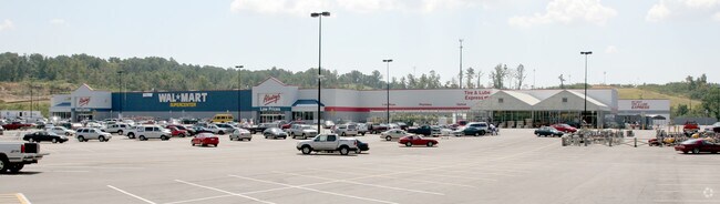
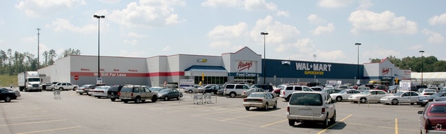
Property Detail
2473 Hackworth Rd
21-00-11-1-002-017.003
THAT PT OF LOT 1A WAL-MART SUPERCENTER ADAMSVILLE RESUR PB 227 PG 82 LYING IN NE1/4 SEC 11 TSP 17S R 4W
Storebuilding
JEFFERSON
A1
Alabama
B and X Area of moderate flood hazard, usually the area between the limits of the 100-year and 500-year floods.
1a
2024
21 AC
2025
Bessemer
012402
Birmingham
181,399 SF
Birmingham, AL
NEARBY LISTINGS FOR SALE OR LEASE
DEMOGRAPHICS near 2473 Hackworth Rd
1 mile
3 mile
5 mile
2025 Total Population
2,293
16,136
34,464
2030 Population
2,259
15,896
34,442
Pop Growth 2025-2030
(1.48%)
(1.49%)
(0.06%)
Average Age
42
42
42
2025 Total Households
914
6,409
13,991
HH Growth 2025-2030
(1.53%)
(1.53%)
(0.01%)
Median Household Inc
$58,912
$58,240
$56,551
Avg Household Size
2.50
2.40
2.40
2025 Avg HH Vehicles
2.00
2.00
2.00
Median Home Value
$170,579
$164,045
$147,066
Median Year Built
1970
1970
1971
Nearby Places
Map Layers
Map Styles
 Street
 Aerial
Layers
 Traffic
 Biking
Places
Listings with unknown addresses are not visible on the map
- Restaurants
- Banks
- Shops
- Fitness
- Groceries
PUBLIC TRANSPORTATION
COMMUTER RAIL
Birmingham (Crescent - Amtrak)
Drive
Walk
Distance
Birmingham (Crescent - Amtrak)
17 min
9.7 mi
AIRPORT
Birmingham-Shuttlesworth International
Drive
Walk
Distance
Birmingham-Shuttlesworth International
23 min
14.6 mi
Freight Ports
Port of Mobile
Drive
Walk
Distance
Port of Mobile
292 min
264.1 mi
Nearby Properties
Address
Land Use
TOTAL SIZE
Lot Size
Zoning
Address
Land Use
TOTAL SIZE
Lot Size
Zoning
32,922 SF
15 AC
I3
Address
Land Use
TOTAL SIZE
Lot Size
Zoning
137,177 SF
10 AC
INST
Address
Land Use
TOTAL SIZE
Lot Size
Zoning
123,937 SF
8 AC
R4
Address
Land Use
TOTAL SIZE
Lot Size
Zoning
31,817 SF
2 AC
CP-C
Address
Land Use
TOTAL SIZE
Lot Size
Zoning
109,753 SF
6 AC
R5
Address
Land Use
TOTAL SIZE
Lot Size
Zoning
83,246 SF
17.51 AC
C1-A
Address
Land Use
TOTAL SIZE
Lot Size
Zoning
44,194 SF
3 AC
I
Address
Land Use
TOTAL SIZE
Lot Size
Zoning
87,260 SF
8 AC
A1-C
Address
Land Use
TOTAL SIZE
Lot Size
Zoning
82,172 SF
4 AC
R4
Address
Land Use
TOTAL SIZE
Lot Size
Zoning
46,492 SF
5 AC
A1-C
Address
Land Use
TOTAL SIZE
Lot Size
Zoning
31,438 SF
9 AC
B2
Address
Land Use
TOTAL SIZE
Lot Size
Zoning
26,458 SF
4 AC
INST
Address
Land Use
TOTAL SIZE
Lot Size
Zoning
34,498 SF
4 AC
INST
Address
Land Use
TOTAL SIZE
Lot Size
Zoning
57,685 SF
7 AC
I3
Address
Land Use
TOTAL SIZE
Lot Size
Zoning
37,100 SF
23 AC
INST
Address
Land Use
TOTAL SIZE
Lot Size
Zoning
16,219 SF
5 AC
INST
Address
Land Use
TOTAL SIZE
Lot Size
Zoning
25,417 SF
6 AC
B3
Address
Land Use
TOTAL SIZE
Lot Size
Zoning
26,114 SF
2 AC
C1
Address
Land Use
TOTAL SIZE
Lot Size
Zoning
26,364 SF
4 AC
IN
Address
Land Use
TOTAL SIZE
Lot Size
Zoning
42,642 SF
6 AC
A1-C
Address
Land Use
TOTAL SIZE
Lot Size
Zoning
24,566 SF
2 AC
R1
Address
Land Use
TOTAL SIZE
Lot Size
Zoning
9,625 SF
5.31 AC
C1
Address
Land Use
TOTAL SIZE
Lot Size
Zoning
4,387 SF
1 AC
A1-C
Address
Land Use
TOTAL SIZE
Lot Size
Zoning
16,500 SF
2 AC
C1
Address
Land Use
TOTAL SIZE
Lot Size
Zoning
13,784 SF
2 AC
C1
Address
Land Use
TOTAL SIZE
Lot Size
Zoning
32,580 SF
5 AC
C1
Address
Land Use
TOTAL SIZE
Lot Size
Zoning
7,200 SF
0.75 AC
C-1
Address
Land Use
TOTAL SIZE
Lot Size
Zoning
21,728 SF
3.27 AC
R-1
Address
Land Use
TOTAL SIZE
Lot Size
Zoning
51,656 SF
4.76 AC
C1
The World's #1 Commercial Real Estate Marketplace
Connect with us
© 2026 CoStar Group
The information above has been obtained from sources believed reliable. While we do not doubt its accuracy we have not verified it and make no guarantee, warranty or representation about it. It is your responsibility to independently confirm its accuracy and completeness. Any projections, opinions, assumptions, or estimates used are for example only and do not represent the current or future performance of the property. The value of this transaction to you depends on tax and other factors which should be evaluated by your tax, financial, and legal advisors. You and your advisors should conduct a careful, independent investigation of the property to determine to your satisfaction the suitability of the property for your needs.