Property Record
2476 Nestle Quarry Rd, Falling Waters, WV 25419
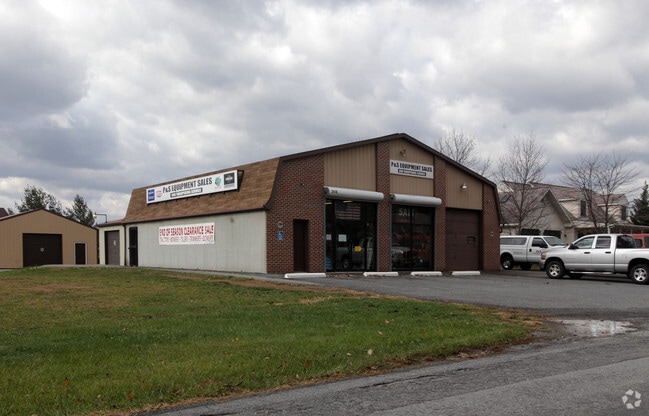
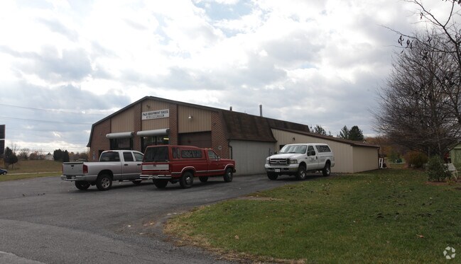
Property Detail
2476 Nestle Quarry Rd
Washington, DC
BERKELEY
Hagerstown-Martinsburg, MD-WV
West Virginia
02-7B-00150000
0.46 AC
Warehouse
Berkeley County
B and X Area of moderate flood hazard, usually the area between the limits of the 100-year and 500-year floods.
NEARBY LISTINGS FOR SALE OR LEASE
-
-
View all Falling Waters listings for sale on LoopNet.com
DEMOGRAPHICS near 2476 Nestle Quarry Rd
1 mile
3 mile
5 mile
2025 Total Population
2,677
13,754
32,765
2030 Population
2,903
14,718
34,719
Pop Growth 2025-2030
+ 8.44%
+ 7.01%
+ 5.96%
Average Age
44
42
42
2025 Total Households
1,094
5,426
12,705
HH Growth 2025-2030
+ 8.50%
+ 6.87%
+ 5.94%
Median Household Inc
$77,227
$84,040
$81,044
Avg Household Size
2.40
2.50
2.50
2025 Avg HH Vehicles
2.00
2.00
2.00
Median Home Value
$235,602
$268,022
$273,987
Median Year Built
1996
1990
1992
Nearby Places
Map Layers
Map Styles
 Street
 Aerial
Transit
 Traffic
 Biking
Places
Listings with unknown addresses are not visible on the map
- Restaurants
- Banks
- Shops
- Fitness
- Groceries
Nearby Properties
Address
Land Use
TOTAL SIZE
Lot Size
Zoning
Address
Land Use
TOTAL SIZE
Lot Size
Zoning
153,846 SF
110.85 AC
U
Address
Land Use
TOTAL SIZE
Lot Size
Zoning
231,293 SF
16.93 AC
PI
Address
Land Use
TOTAL SIZE
Lot Size
Zoning
36,000 SF
23.49 AC
HI
Address
Land Use
TOTAL SIZE
Lot Size
Zoning
2,324 SF
6 AC
TR
Address
Land Use
TOTAL SIZE
Lot Size
Zoning
247,962 SF
14.66 AC
PI
Address
Land Use
TOTAL SIZE
Lot Size
Zoning
9.83 AC
Address
Land Use
TOTAL SIZE
Lot Size
Zoning
327,100 SF
41.81 AC
PI
Address
Land Use
TOTAL SIZE
Lot Size
Zoning
12,144 SF
8.30 AC
U
Address
Land Use
TOTAL SIZE
Lot Size
Zoning
102,900 SF
10.70 AC
PI
Address
Land Use
TOTAL SIZE
Lot Size
Zoning
122,450 SF
13.14 AC
PI
Address
Land Use
TOTAL SIZE
Lot Size
Zoning
29,276 SF
15 AC
PI
Address
Land Use
TOTAL SIZE
Lot Size
Zoning
15,936 SF
4.14 AC
U
Address
Land Use
TOTAL SIZE
Lot Size
Zoning
23,214 SF
4.39 AC
TR
Address
Land Use
TOTAL SIZE
Lot Size
Zoning
1,920 SF
2,287 AC
HR
Address
Land Use
TOTAL SIZE
Lot Size
Zoning
1,800 SF
448.54 AC
U
Address
Land Use
TOTAL SIZE
Lot Size
Zoning
14,604 SF
6.41 AC
TR
Address
Land Use
TOTAL SIZE
Lot Size
Zoning
14,161 SF
218 AC
U
Address
Land Use
TOTAL SIZE
Lot Size
Zoning
12.64 AC
Address
Land Use
TOTAL SIZE
Lot Size
Zoning
19,367 SF
4.06 AC
TR
Address
Land Use
TOTAL SIZE
Lot Size
Zoning
14,269 SF
12.43 AC
PI
Address
Land Use
TOTAL SIZE
Lot Size
Zoning
2,300 SF
2.35 AC
TR
Address
Land Use
TOTAL SIZE
Lot Size
Zoning
1,373 SF
47.74 AC
Address
Land Use
TOTAL SIZE
Lot Size
Zoning
15,000 SF
16.43 AC
BG
Address
Land Use
TOTAL SIZE
Lot Size
Zoning
65,448 SF
5.10 AC
PI
Address
Land Use
TOTAL SIZE
Lot Size
Zoning
22,500 SF
4.08 AC
EC(T)
Address
Land Use
TOTAL SIZE
Lot Size
Zoning
7,594 SF
23.48 AC
U
Address
Land Use
TOTAL SIZE
Lot Size
Zoning
2,678 SF
5.11 AC
U
Address
Land Use
TOTAL SIZE
Lot Size
Zoning
38,398 SF
4.25 AC
GC
Address
Land Use
TOTAL SIZE
Lot Size
Zoning
29,960 SF
9.18 AC
PI
Address
Land Use
TOTAL SIZE
Lot Size
Zoning
20,000 SF
7.56 AC
PI
The World's #1 Commercial Real Estate Marketplace
Connect with us
© 2026 CoStar Group
The information above has been obtained from sources believed reliable. While we do not doubt its accuracy we have not verified it and make no guarantee, warranty or representation about it. It is your responsibility to independently confirm its accuracy and completeness. Any projections, opinions, assumptions, or estimates used are for example only and do not represent the current or future performance of the property. The value of this transaction to you depends on tax and other factors which should be evaluated by your tax, financial, and legal advisors. You and your advisors should conduct a careful, independent investigation of the property to determine to your satisfaction the suitability of the property for your needs.