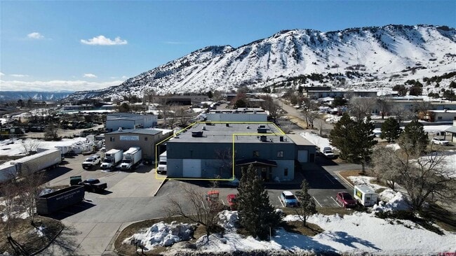
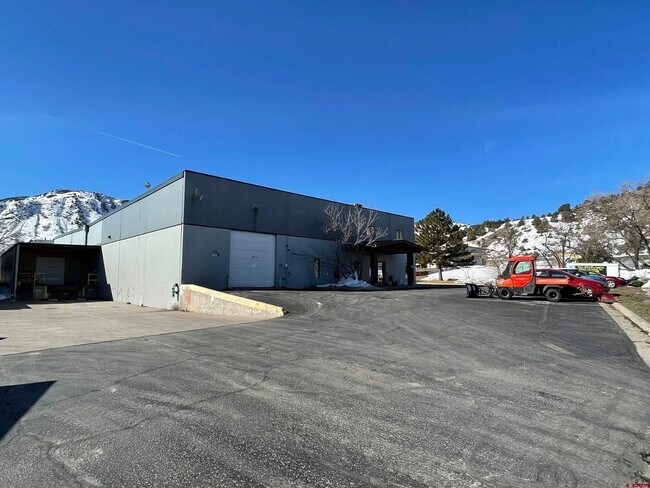
Property Record
248 Bodo Dr, Durango, CO 81303


Property Detail
248 Bodo Dr
R000003
Coors Split Condo Unit: A
Commercialcondominium
SUBDIVISION: COORS SPLIT CONDO UNIT: A DESC: PL #548021 5/21/87 248 BODO DR #A 248 BODO DR #B DURANGO 81303
X
La Plata
08067C0700G
Colorado
2024
0.35 AC
2025
Colorado Southwest Area
971100
Other Market Areas
15,000 SF
Durango, CO
NEARBY LISTINGS FOR SALE OR LEASE
-
-
View all Durango listings for lease on LoopNet.com
DEMOGRAPHICS near 248 Bodo Dr
1 mile
3 mile
5 mile
2024 Total Population
135
8,640
24,113
2029 Population
140
8,900
24,864
Pop Growth 2024-2029
+ 3.70%
+ 3.01%
+ 3.11%
Average Age
39
38
39
2024 Total Households
63
3,886
10,128
HH Growth 2024-2029
+ 3.17%
+ 2.75%
+ 2.82%
Median Household Inc
$47,500
$67,889
$75,687
Avg Household Size
2.00
2.10
2.20
2024 Avg HH Vehicles
2.00
2.00
2.00
Median Home Value
$499,999
$636,653
$603,663
Median Year Built
1999
1980
1986
Nearby Places
Map Layers
Map Styles
 Street
 Aerial
Transit
 Traffic
 Biking
Places
Listings with unknown addresses are not visible on the map
- Restaurants
- Banks
- Shops
- Fitness
- Groceries
PUBLIC TRANSPORTATION
AIRPORT
Durango-La Plata County
Drive
Walk
Distance
Durango-La Plata County
21 min
12.8 mi
Freight Ports
Port of San Diego
Drive
Walk
Distance
Port of San Diego
932 min
800.2 mi
SALE & LEASE HISTORY
LISTING DATE
SALE/LEASE

Mar 16, 2023
For Lease
Nearby Properties
Address
Land Use
TOTAL SIZE
Lot Size
Zoning
Address
Land Use
TOTAL SIZE
Lot Size
Zoning
1,237,361 SF
230.69 AC
Address
Land Use
TOTAL SIZE
Lot Size
Zoning
309,540 SF
49.68 AC
Address
Land Use
TOTAL SIZE
Lot Size
Zoning
151,412 SF
2.60 AC
Address
Land Use
TOTAL SIZE
Lot Size
Zoning
108,918 SF
27.44 AC
Address
Land Use
TOTAL SIZE
Lot Size
Zoning
30,443 SF
0.65 AC
Address
Land Use
TOTAL SIZE
Lot Size
Zoning
179,312 SF
8.01 AC
Address
Land Use
TOTAL SIZE
Lot Size
Zoning
108,697 SF
13.51 AC
Address
Land Use
TOTAL SIZE
Lot Size
Zoning
112,681 SF
1.12 AC
Address
Land Use
TOTAL SIZE
Lot Size
Zoning
159,163 SF
5.50 AC
Address
Land Use
TOTAL SIZE
Lot Size
Zoning
180,591 SF
13.50 AC
Address
Land Use
TOTAL SIZE
Lot Size
Zoning
87,592 SF
10.30 AC
Address
Land Use
TOTAL SIZE
Lot Size
Zoning
48,369 SF
0.63 AC
Address
Land Use
TOTAL SIZE
Lot Size
Zoning
58,393 SF
10.20 AC
Address
Land Use
TOTAL SIZE
Lot Size
Zoning
78,166 SF
6.73 AC
Address
Land Use
TOTAL SIZE
Lot Size
Zoning
51,923 SF
Address
Land Use
TOTAL SIZE
Lot Size
Zoning
45,340 SF
3.74 AC
Address
Land Use
TOTAL SIZE
Lot Size
Zoning
65,704 SF
2.27 AC
Address
Land Use
TOTAL SIZE
Lot Size
Zoning
23,667 SF
1.91 AC
Address
Land Use
TOTAL SIZE
Lot Size
Zoning
60,809 SF
3.02 AC
Address
Land Use
TOTAL SIZE
Lot Size
Zoning
51,561 SF
37.58 AC
Address
Land Use
TOTAL SIZE
Lot Size
Zoning
29,546 SF
4.14 AC
Address
Land Use
TOTAL SIZE
Lot Size
Zoning
23,503 SF
14.22 AC
Address
Land Use
TOTAL SIZE
Lot Size
Zoning
112,292 SF
9.21 AC
Address
Land Use
TOTAL SIZE
Lot Size
Zoning
45,481 SF
5 AC
Address
Land Use
TOTAL SIZE
Lot Size
Zoning
72,094 SF
0.57 AC
Address
Land Use
TOTAL SIZE
Lot Size
Zoning
48,258 SF
3.30 AC
Address
Land Use
TOTAL SIZE
Lot Size
Zoning
49,001 SF
7.61 AC
Address
Land Use
TOTAL SIZE
Lot Size
Zoning
52,704 SF
1.73 AC
Address
Land Use
TOTAL SIZE
Lot Size
Zoning
45,080 SF
1.76 AC
Address
Land Use
TOTAL SIZE
Lot Size
Zoning
42,714 SF
2.05 AC
The World's #1 Commercial Real Estate Marketplace
Connect with us
© 2026 CoStar Group
The information above has been obtained from sources believed reliable. While we do not doubt its accuracy we have not verified it and make no guarantee, warranty or representation about it. It is your responsibility to independently confirm its accuracy and completeness. Any projections, opinions, assumptions, or estimates used are for example only and do not represent the current or future performance of the property. The value of this transaction to you depends on tax and other factors which should be evaluated by your tax, financial, and legal advisors. You and your advisors should conduct a careful, independent investigation of the property to determine to your satisfaction the suitability of the property for your needs.