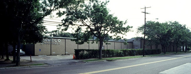
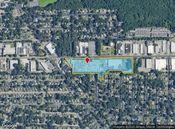
Property Record
248 Wyandanch Ave, West Babylon, NY 11704
NEARBY LISTINGS FOR SALE OR LEASE
Property Detail
248 Wyandanch Ave
Nassau County-Suffolk County, NY
Map Belmont Heights
0100-082-00-02-00-073-001
FM 368 & 462 BL 42, 43 & 44 VARIOUS LTS & DESC PROP
Industrialgeneral
Suffolk
X
New York
36103C0855H
73
2024
9.31 AC
2024
Deer Park
122502
Long Island (New York)
164,948 SF
DEMOGRAPHICS near 248 Wyandanch Ave
1 Mile
3 Mile
5 Mile
2024 Total Population
17,411
114,981
277,031
2029 Population
17,023
112,282
271,090
Pop Growth 2024-2029
(2.23%)
(2.35%)
(2.14%)
Average Age
37
40
41
2024 Total Households
4,595
36,278
89,260
HH Growth 2024-2029
(2.44%)
(2.57%)
(2.33%)
Median Household Inc
$102,626
$115,254
$116,081
Avg Household Size
3.50
3.00
3.00
2024 Avg HH Vehicles
2.00
2.00
2.00
Median Home Value
$424,259
$450,235
$469,995
Median Year Built
1965
1962
1962
Nearby Places
- Restaurants
- Banks
- Shops
- Fitness
- Groceries
PUBLIC TRANSPORTATION
COMMUTER RAIL
Wyandanch Station (Ronkonkoma Branch - Long Island Rail Road)
DRIVE
WALK
Distance
Wyandanch Station (Ronkonkoma Branch - Long Island Rail Road)
5 min
1.7 mi
Pinelawn Station (Ronkonkoma Branch - Long Island Rail Road)
DRIVE
WALK
Distance
Pinelawn Station (Ronkonkoma Branch - Long Island Rail Road)
8 min
3.2 mi
AIRPORT
Long Island MacArthur
DRIVE
WALK
Distance
Long Island MacArthur
28 min
17.9 mi
John F Kennedy International
DRIVE
WALK
Distance
John F Kennedy International
41 min
28.9 mi
LaGuardia
DRIVE
WALK
Distance
LaGuardia
51 min
35.8 mi
Freight Ports
NY - Red Hook Container Terminal
DRIVE
WALK
Distance
NY - Red Hook Container Terminal
61 min
40.3 mi
Nearby Properties
Address
Land Use
TOTAL SIZE
Lot Size
Zoning
Address
Land Use
TOTAL SIZE
Lot Size
Zoning
6.66 AC
A
Address
Land Use
TOTAL SIZE
Lot Size
Zoning
13.30 AC
A
Address
Land Use
TOTAL SIZE
Lot Size
Zoning
756 SF
0.36 AC
B1
Address
Land Use
TOTAL SIZE
Lot Size
Zoning
6.37 AC
BUS3
Address
Land Use
TOTAL SIZE
Lot Size
Zoning
2,388 SF
0.36 AC
B1
Address
Land Use
TOTAL SIZE
Lot Size
Zoning
400 AC
A
Address
Land Use
TOTAL SIZE
Lot Size
Zoning
1,680 SF
0.15 AC
B1
Address
Land Use
TOTAL SIZE
Lot Size
Zoning
5.95 AC
C
Address
Land Use
TOTAL SIZE
Lot Size
Zoning
2.24 AC
Address
Land Use
TOTAL SIZE
Lot Size
Zoning
0.55 AC
VILLA
Address
Land Use
TOTAL SIZE
Lot Size
Zoning
16.90 AC
EA
Address
Land Use
TOTAL SIZE
Lot Size
Zoning
3.80 AC
BUS1
Address
Land Use
TOTAL SIZE
Lot Size
Zoning
11.10 AC
SC
Address
Land Use
TOTAL SIZE
Lot Size
Zoning
114.70 AC
A
Address
Land Use
TOTAL SIZE
Lot Size
Zoning
292.40 AC
A
Address
Land Use
TOTAL SIZE
Lot Size
Zoning
0.26 AC
R20
Address
Land Use
TOTAL SIZE
Lot Size
Zoning
52.20 AC
R40
Address
Land Use
TOTAL SIZE
Lot Size
Zoning
2.09 AC
BUS3
Address
Land Use
TOTAL SIZE
Lot Size
Zoning
16.81 AC
Address
Land Use
TOTAL SIZE
Lot Size
Zoning
248.60 AC
A
Address
Land Use
TOTAL SIZE
Lot Size
Zoning
200,065 SF
16.60 AC
GA
Address
Land Use
TOTAL SIZE
Lot Size
Zoning
12.50 AC
C
Address
Land Use
TOTAL SIZE
Lot Size
Zoning
15.20 AC
Address
Land Use
TOTAL SIZE
Lot Size
Zoning
0.94 AC
A
Address
Land Use
TOTAL SIZE
Lot Size
Zoning
232.90 AC
A
Address
Land Use
TOTAL SIZE
Lot Size
Zoning
10.10 AC
SC
Address
Land Use
TOTAL SIZE
Lot Size
Zoning
1.08 AC
CR200
Address
Land Use
TOTAL SIZE
Lot Size
Zoning
1.02 AC
BUS1
Address
Land Use
TOTAL SIZE
Lot Size
Zoning
49.49 AC
B
Address
Land Use
TOTAL SIZE
Lot Size
Zoning
236 AC
A
The World's #1 Commercial Real Estate Marketplace
Connect with us
© 2025 CoStar Group
The information above has been obtained from sources believed reliable. While we do not doubt its accuracy we have not verified it and make no guarantee, warranty or representation about it. It is your responsibility to independently confirm its accuracy and completeness. Any projections, opinions, assumptions, or estimates used are for example only and do not represent the current or future performance of the property. The value of this transaction to you depends on tax and other factors which should be evaluated by your tax, financial, and legal advisors. You and your advisors should conduct a careful, independent investigation of the property to determine to your satisfaction the suitability of the property for your needs.