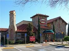
Property Record
2480 Highway 6 And 50, Grand Junction, CO 81505
NEARBY LISTINGS FOR SALE OR LEASE
Property Detail
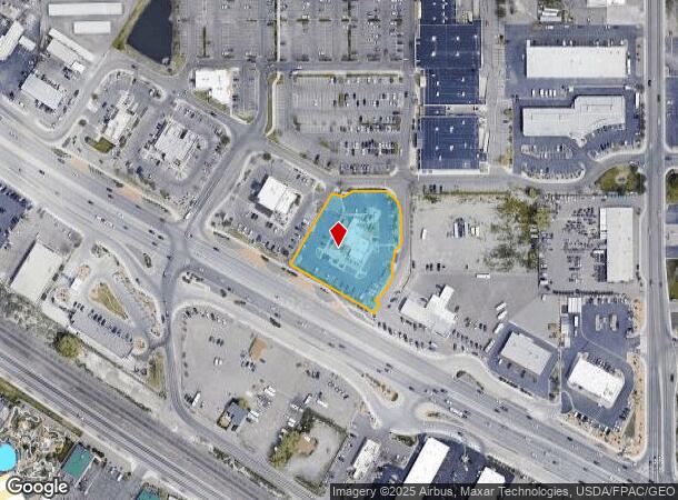
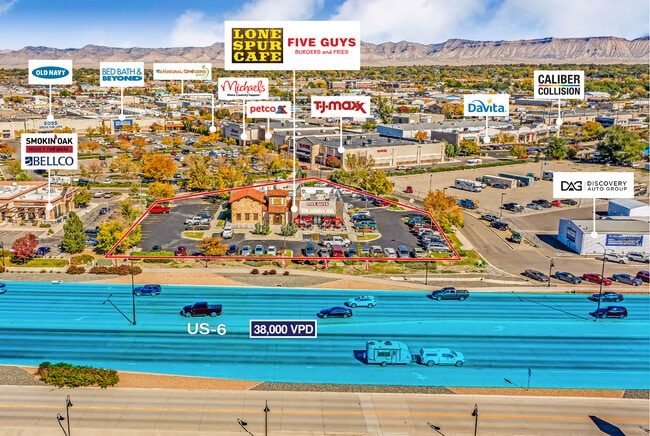
2480 Highway 6 And 50
Grand Junction, CO
Grand Mesa Center
2945-091-21-005
LOT 5 GRAND MESA CENTER SEC 9 1S 1W - 1.52AC
Commercialnec
Mesa
X
Colorado
08077C0804G
5
2023
1.52 AC
2024
Colorado Northwest Area
000900
Other Market Areas
8,091 SF
DEMOGRAPHICS near 2480 Highway 6 And 50
1 Mile
3 Mile
5 Mile
2024 Total Population
2,971
43,606
85,336
2029 Population
3,158
46,039
89,794
Pop Growth 2024-2029
+ 6.29%
+ 5.58%
+ 5.22%
Average Age
41
42
42
2024 Total Households
1,335
18,784
35,840
HH Growth 2024-2029
+ 6.29%
+ 5.80%
+ 5.37%
Median Household Inc
$63,689
$62,015
$63,635
Avg Household Size
2.20
2.10
2.20
2024 Avg HH Vehicles
2.00
2.00
2.00
Median Home Value
$313,976
$367,969
$364,665
Median Year Built
1994
1981
1984
Nearby Places
Map Layers
Map Styles
 Street
 Aerial
- Restaurants
- Banks
- Shops
- Fitness
- Groceries
PUBLIC TRANSPORTATION
COMMUTER RAIL
DRIVE
WALK
Distance
6 min
2.3 mi
AIRPORT
Grand Junction Regional
DRIVE
WALK
Distance
Grand Junction Regional
13 min
7.5 mi
SALE & LEASE HISTORY
LISTING DATE
SALE/LEASE

Sep 07, 2022
For Sale
Oct 30, 2023
For Lease
Oct 25, 2022
For Sale
Nov 09, 2022
For Sale
Jul 03, 2019
For Lease
Jul 03, 2019
For Sale
Aug 15, 2022
For Sale
Nearby Properties
Address
Land Use
TOTAL SIZE
Lot Size
Zoning
Address
Land Use
TOTAL SIZE
Lot Size
Zoning
889,724 SF
22.01 AC
PD
Address
Land Use
TOTAL SIZE
Lot Size
Zoning
278,357 SF
29.28 AC
MU
Address
Land Use
TOTAL SIZE
Lot Size
Zoning
365,495 SF
20.90 AC
CSR
Address
Land Use
TOTAL SIZE
Lot Size
Zoning
482,392 SF
24.70 AC
CSR
Address
Land Use
TOTAL SIZE
Lot Size
Zoning
429,786 SF
16.99 AC
CSR
Address
Land Use
TOTAL SIZE
Lot Size
Zoning
444,676 SF
29.47 AC
CSR
Address
Land Use
TOTAL SIZE
Lot Size
Zoning
181,976 SF
14.80 AC
CSR
Address
Land Use
TOTAL SIZE
Lot Size
Zoning
90,528 SF
6.09 AC
MU
Address
Land Use
TOTAL SIZE
Lot Size
Zoning
206,585 SF
18.98 AC
C-2
Address
Land Use
TOTAL SIZE
Lot Size
Zoning
75,770 SF
82.62 AC
CSR
Address
Land Use
TOTAL SIZE
Lot Size
Zoning
130,260 SF
0.20 AC
C-1
Address
Land Use
TOTAL SIZE
Lot Size
Zoning
399,553 SF
C-1
Address
Land Use
TOTAL SIZE
Lot Size
Zoning
127,269 SF
3.21 AC
B-2
Address
Land Use
TOTAL SIZE
Lot Size
Zoning
113,925 SF
0.16 AC
PD
Address
Land Use
TOTAL SIZE
Lot Size
Zoning
82,986 SF
4.20 AC
PD
Address
Land Use
TOTAL SIZE
Lot Size
Zoning
94,818 SF
19.78 AC
RSF-4
Address
Land Use
TOTAL SIZE
Lot Size
Zoning
69,390 SF
0.14 AC
C-1
Address
Land Use
TOTAL SIZE
Lot Size
Zoning
93,531 SF
5.19 AC
Address
Land Use
TOTAL SIZE
Lot Size
Zoning
94,639 SF
0.16 AC
C-1
Address
Land Use
TOTAL SIZE
Lot Size
Zoning
97,602 SF
23.51 AC
RSF-4
Address
Land Use
TOTAL SIZE
Lot Size
Zoning
126,114 SF
13.75 AC
B-2
Address
Land Use
TOTAL SIZE
Lot Size
Zoning
66,178 SF
2.02 AC
PD
Address
Land Use
TOTAL SIZE
Lot Size
Zoning
86,946 SF
5.52 AC
C-1
Address
Land Use
TOTAL SIZE
Lot Size
Zoning
83,518 SF
1.45 AC
CSR
Address
Land Use
TOTAL SIZE
Lot Size
Zoning
70,394 SF
6.19 AC
PD
Address
Land Use
TOTAL SIZE
Lot Size
Zoning
215,583 SF
20.40 AC
C-1
Address
Land Use
TOTAL SIZE
Lot Size
Zoning
85,303 SF
8.45 AC
C-2
Address
Land Use
TOTAL SIZE
Lot Size
Zoning
79,905 SF
8.43 AC
PD
Address
Land Use
TOTAL SIZE
Lot Size
Zoning
87,806 SF
0.11 AC
The World's #1 Commercial Real Estate Marketplace
Connect with us
© 2025 CoStar Group
The information above has been obtained from sources believed reliable. While we do not doubt its accuracy we have not verified it and make no guarantee, warranty or representation about it. It is your responsibility to independently confirm its accuracy and completeness. Any projections, opinions, assumptions, or estimates used are for example only and do not represent the current or future performance of the property. The value of this transaction to you depends on tax and other factors which should be evaluated by your tax, financial, and legal advisors. You and your advisors should conduct a careful, independent investigation of the property to determine to your satisfaction the suitability of the property for your needs.