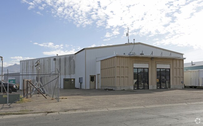
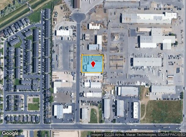
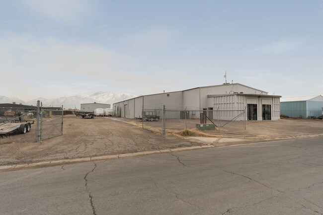
Property Record
2480 S 2050 W, West Haven, UT 84401
NEARBY LISTINGS FOR SALE OR LEASE
Property Detail
2480 S 2050 W
Ogden-Clearfield, UT
Circle R Industrial Park Subdivision
15-131-0006
ALL OF LOT 17, CIRCLE R INDUSTRIAL PARK SUBDIVISION, WEST HAVEN CITY, WEBER COUNTY, UTAH. TOGETHER WITH HALF OF THE VACATED
Manufacturinglight
Weber
X
Utah
49057C0407F
16-17
2025
0.77 AC
2025
Davis North
210518
Salt Lake City
13,374 SF
DEMOGRAPHICS near 2480 S 2050 W
1 Mile
3 Mile
5 Mile
2024 Total Population
2,884
36,801
172,154
2029 Population
3,114
39,865
185,189
Pop Growth 2024-2029
+ 7.98%
+ 8.33%
+ 7.57%
Average Age
33
36
35
2024 Total Households
998
12,459
60,469
HH Growth 2024-2029
+ 8.22%
+ 8.39%
+ 7.75%
Median Household Inc
$78,391
$72,002
$64,565
Avg Household Size
2.90
2.80
2.80
2024 Avg HH Vehicles
3.00
2.00
2.00
Median Home Value
$450,566
$368,813
$330,478
Median Year Built
2009
1996
1977
Nearby Places
Map Layers
Map Styles
 Street
 Aerial
- Restaurants
- Banks
- Shops
- Fitness
- Groceries
PUBLIC TRANSPORTATION
COMMUTER RAIL
Roy (FrontRunner North - Utah Transit Authority (UTA))
DRIVE
WALK
Distance
Roy (FrontRunner North - Utah Transit Authority (UTA))
6 min
3.1 mi
Ogden (FrontRunner North - Utah Transit Authority (UTA))
DRIVE
WALK
Distance
Ogden (FrontRunner North - Utah Transit Authority (UTA))
8 min
3.9 mi
AIRPORT
Salt Lake City International
DRIVE
WALK
Distance
Salt Lake City International
48 min
38.1 mi
SALE & LEASE HISTORY
LISTING DATE
SALE/LEASE

Dec 05, 2018
For Lease
Dec 05, 2017
For Lease
Nearby Properties
Address
Land Use
TOTAL SIZE
Lot Size
Zoning
Address
Land Use
TOTAL SIZE
Lot Size
Zoning
841,756 SF
45.79 AC
Address
Land Use
TOTAL SIZE
Lot Size
Zoning
128,867 SF
3.36 AC
Address
Land Use
TOTAL SIZE
Lot Size
Zoning
97,932 SF
3.07 AC
Address
Land Use
TOTAL SIZE
Lot Size
Zoning
152,877 SF
4.96 AC
Address
Land Use
TOTAL SIZE
Lot Size
Zoning
9,464 SF
6.82 AC
Address
Land Use
TOTAL SIZE
Lot Size
Zoning
71,940 SF
11 AC
Address
Land Use
TOTAL SIZE
Lot Size
Zoning
21,684 SF
8.38 AC
Address
Land Use
TOTAL SIZE
Lot Size
Zoning
48,177 SF
5.54 AC
Address
Land Use
TOTAL SIZE
Lot Size
Zoning
106,752 SF
10.35 AC
Address
Land Use
TOTAL SIZE
Lot Size
Zoning
8,580 SF
6.40 AC
Address
Land Use
TOTAL SIZE
Lot Size
Zoning
66,896 SF
7.50 AC
Address
Land Use
TOTAL SIZE
Lot Size
Zoning
101,191 SF
4.14 AC
Address
Land Use
TOTAL SIZE
Lot Size
Zoning
119,043 SF
2.05 AC
Address
Land Use
TOTAL SIZE
Lot Size
Zoning
95,949 SF
3.29 AC
Address
Land Use
TOTAL SIZE
Lot Size
Zoning
149,400 SF
26.88 AC
Address
Land Use
TOTAL SIZE
Lot Size
Zoning
166,800 SF
0.12 AC
Address
Land Use
TOTAL SIZE
Lot Size
Zoning
255,596 SF
15.98 AC
Address
Land Use
TOTAL SIZE
Lot Size
Zoning
99,775 SF
6.32 AC
Address
Land Use
TOTAL SIZE
Lot Size
Zoning
23,932 SF
5.53 AC
Address
Land Use
TOTAL SIZE
Lot Size
Zoning
21,680 SF
2.98 AC
Address
Land Use
TOTAL SIZE
Lot Size
Zoning
151,615 SF
5.08 AC
Address
Land Use
TOTAL SIZE
Lot Size
Zoning
94,178 SF
7.04 AC
The World's #1 Commercial Real Estate Marketplace
Connect with us
© 2025 CoStar Group
The information above has been obtained from sources believed reliable. While we do not doubt its accuracy we have not verified it and make no guarantee, warranty or representation about it. It is your responsibility to independently confirm its accuracy and completeness. Any projections, opinions, assumptions, or estimates used are for example only and do not represent the current or future performance of the property. The value of this transaction to you depends on tax and other factors which should be evaluated by your tax, financial, and legal advisors. You and your advisors should conduct a careful, independent investigation of the property to determine to your satisfaction the suitability of the property for your needs.