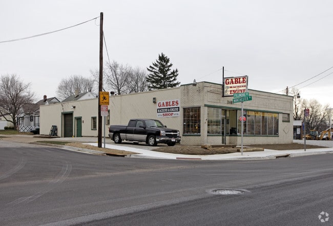
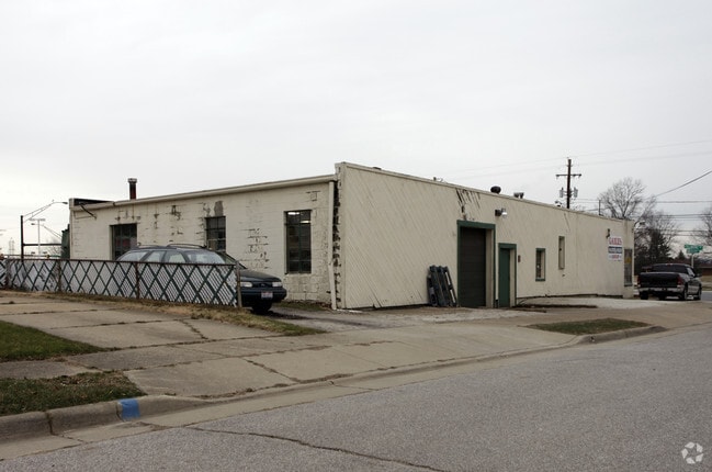
Property Record
2481 Manchester Rd, Akron, OH 44314

Save to a Folder
{{folder.Name}}
{{folder.ListingIds.length}} Properties
{{folder.ListingIds.length}} Property
Create a New Folder
Property Detail
2481 Manchester Rd
Akron, OH
NESMITH PK LOT 47 ALL FILLMORE AVE LESS PT FOR RD 5-WD
67-32041
Summit
Storebuilding
Ohio
B and X Area of moderate flood hazard, usually the area between the limits of the 100-year and 500-year floods.
47
2025
0.14 AC
2026
Akron
505900
Cleveland
3,400 SF
NEARBY LISTINGS FOR SALE OR LEASE
DEMOGRAPHICS near 2481 Manchester Rd
1 mile
3 mile
5 mile
2025 Total Population
6,378
75,881
168,510
2030 Population
6,401
76,138
169,506
Pop Growth 2025-2030
+ 0.36%
+ 0.34%
+ 0.59%
Average Age
41
41
40
2025 Total Households
2,804
33,135
72,458
HH Growth 2025-2030
+ 0.32%
+ 0.27%
+ 0.56%
Median Household Inc
$50,266
$48,025
$46,967
Avg Household Size
2.20
2.20
2.20
2025 Avg HH Vehicles
2.00
2.00
2.00
Median Home Value
$106,086
$124,493
$134,578
Median Year Built
1951
1953
1953
Nearby Places
Map Layers
Map Styles
 Street
 Aerial
Layers
 Traffic
 Biking
Places
Listings with unknown addresses are not visible on the map
- Restaurants
- Banks
- Shops
- Fitness
- Groceries
PUBLIC TRANSPORTATION
COMMUTER RAIL
Drive
Walk
Distance
12 min
7.0 mi
Drive
Walk
Distance
18 min
9.6 mi
AIRPORT
Akron-Canton Regional
Drive
Walk
Distance
Akron-Canton Regional
17 min
12.0 mi
Cleveland-Hopkins International
Drive
Walk
Distance
Cleveland-Hopkins International
58 min
41.5 mi
SALE & LEASE HISTORY
LISTING DATE
SALE/LEASE

Sep 23, 2016
For Sale
Mar 28, 2017
For Sale
Nearby Properties
Address
Land Use
TOTAL SIZE
Lot Size
Zoning
Address
Land Use
TOTAL SIZE
Lot Size
Zoning
1,397,532 SF
92.95 AC
Address
Land Use
TOTAL SIZE
Lot Size
Zoning
203,458 SF
10.41 AC
Address
Land Use
TOTAL SIZE
Lot Size
Zoning
9.19 AC
Address
Land Use
TOTAL SIZE
Lot Size
Zoning
132,611 SF
3.56 AC
Address
Land Use
TOTAL SIZE
Lot Size
Zoning
423,125 SF
5.57 AC
Address
Land Use
TOTAL SIZE
Lot Size
Zoning
227,634 SF
21.46 AC
Address
Land Use
TOTAL SIZE
Lot Size
Zoning
91,678 SF
5.24 AC
Address
Land Use
TOTAL SIZE
Lot Size
Zoning
Address
Land Use
TOTAL SIZE
Lot Size
Zoning
154,926 SF
12.38 AC
Address
Land Use
TOTAL SIZE
Lot Size
Zoning
126,708 SF
3.26 AC
Address
Land Use
TOTAL SIZE
Lot Size
Zoning
121,006 SF
6.09 AC
Address
Land Use
TOTAL SIZE
Lot Size
Zoning
22,977 SF
263.47 AC
Address
Land Use
TOTAL SIZE
Lot Size
Zoning
57,180 SF
6.67 AC
Address
Land Use
TOTAL SIZE
Lot Size
Zoning
8.59 AC
Address
Land Use
TOTAL SIZE
Lot Size
Zoning
148.10 AC
Address
Land Use
TOTAL SIZE
Lot Size
Zoning
240,497 SF
13.37 AC
Address
Land Use
TOTAL SIZE
Lot Size
Zoning
51,520 SF
2.70 AC
Address
Land Use
TOTAL SIZE
Lot Size
Zoning
127,297 SF
6.03 AC
Address
Land Use
TOTAL SIZE
Lot Size
Zoning
59,492 SF
5.51 AC
Address
Land Use
TOTAL SIZE
Lot Size
Zoning
53,074 SF
7.29 AC
Address
Land Use
TOTAL SIZE
Lot Size
Zoning
130,893 SF
11.70 AC
Address
Land Use
TOTAL SIZE
Lot Size
Zoning
258,686 SF
19.52 AC
Address
Land Use
TOTAL SIZE
Lot Size
Zoning
52,640 SF
0.42 AC
Address
Land Use
TOTAL SIZE
Lot Size
Zoning
136,025 SF
10.53 AC
Address
Land Use
TOTAL SIZE
Lot Size
Zoning
56,660 SF
34.63 AC
Address
Land Use
TOTAL SIZE
Lot Size
Zoning
113,321 SF
13.32 AC
Address
Land Use
TOTAL SIZE
Lot Size
Zoning
125,245 SF
6.11 AC
Address
Land Use
TOTAL SIZE
Lot Size
Zoning
65,436 SF
34.84 AC
Address
Land Use
TOTAL SIZE
Lot Size
Zoning
61,897 SF
2.75 AC
Address
Land Use
TOTAL SIZE
Lot Size
Zoning
5.99 AC
The World's #1 Commercial Real Estate Marketplace
Connect with us
© 2026 CoStar Group
The information above has been obtained from sources believed reliable. While we do not doubt its accuracy we have not verified it and make no guarantee, warranty or representation about it. It is your responsibility to independently confirm its accuracy and completeness. Any projections, opinions, assumptions, or estimates used are for example only and do not represent the current or future performance of the property. The value of this transaction to you depends on tax and other factors which should be evaluated by your tax, financial, and legal advisors. You and your advisors should conduct a careful, independent investigation of the property to determine to your satisfaction the suitability of the property for your needs.