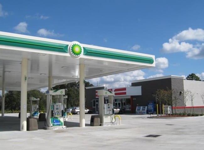
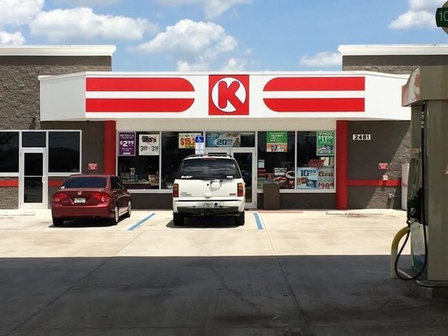
Property Record
2481 N Narcoossee Rd, Saint Cloud, FL 34771

NEARBY LISTINGS FOR SALE OR LEASE
Property Detail
2481 N Narcoossee Rd
Orlando-Kissimmee-Sanford, FL
Narcoossee Center
17-25-31-4265-0001-0010
NARCOOSSEE CENTER PB 9 PG 8 LOT 1
Storebuilding
Osceola
X
Florida
12095C0675G
1
2024
1.02 AC
2025
Osceola Outlying
043700
Orlando
8,992 SF
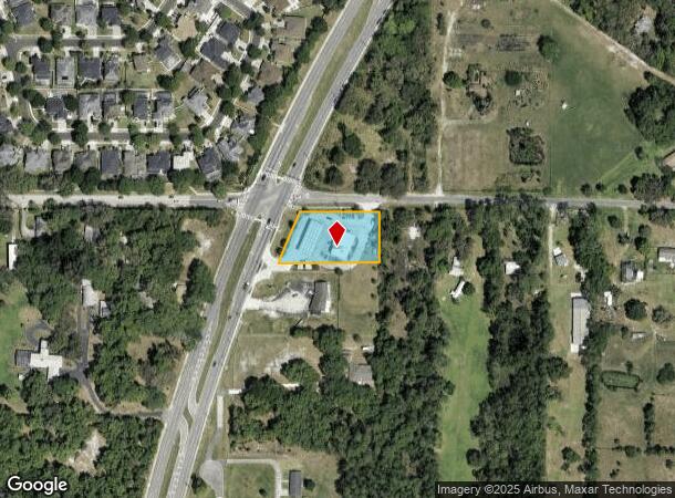
DEMOGRAPHICS near 2481 N Narcoossee Rd
1 Mile
3 Mile
5 Mile
2024 Total Population
4,916
25,325
60,237
2029 Population
5,856
30,033
69,866
Pop Growth 2024-2029
+ 19.12%
+ 18.59%
+ 15.99%
Average Age
39
38
38
2024 Total Households
1,632
8,212
20,253
HH Growth 2024-2029
+ 19.12%
+ 18.39%
+ 15.63%
Median Household Inc
$109,700
$98,608
$92,226
Avg Household Size
3.00
3.10
2.90
2024 Avg HH Vehicles
2.00
2.00
2.00
Median Home Value
$380,635
$385,987
$391,157
Median Year Built
2006
2010
2010
Nearby Places
Map Layers
Map Styles
 Street
 Aerial
- Restaurants
- Banks
- Shops
- Fitness
- Groceries
PUBLIC TRANSPORTATION
AIRPORT
Orlando International
DRIVE
WALK
Distance
Orlando International
25 min
15.5 mi
Orlando Sanford International
DRIVE
WALK
Distance
Orlando Sanford International
48 min
36.7 mi
Freight Ports
Port Canaveral
DRIVE
WALK
Distance
Port Canaveral
62 min
49.1 mi
SALE & LEASE HISTORY
LISTING DATE
SALE/LEASE

Sep 25, 2016
For Lease
Nearby Properties
Address
Land Use
TOTAL SIZE
Lot Size
Zoning
Address
Land Use
TOTAL SIZE
Lot Size
Zoning
325,067 SF
13.38 AC
PD/AN
Address
Land Use
TOTAL SIZE
Lot Size
Zoning
403,703 SF
11.96 AC
P-D
Address
Land Use
TOTAL SIZE
Lot Size
Zoning
397,515 SF
1.16 AC
P-D
Address
Land Use
TOTAL SIZE
Lot Size
Zoning
161,219 SF
30 AC
PD/AN
Address
Land Use
TOTAL SIZE
Lot Size
Zoning
266,284 SF
50.40 AC
IN
Address
Land Use
TOTAL SIZE
Lot Size
Zoning
126,656 SF
1.98 AC
PD/AN
Address
Land Use
TOTAL SIZE
Lot Size
Zoning
90,917 SF
3.16 AC
P-D
Address
Land Use
TOTAL SIZE
Lot Size
Zoning
50,430 SF
10.80 AC
OAC
Address
Land Use
TOTAL SIZE
Lot Size
Zoning
18,354 SF
129.24 AC
OPD
Address
Land Use
TOTAL SIZE
Lot Size
Zoning
112,255 SF
16.31 AC
OPUD
Address
Land Use
TOTAL SIZE
Lot Size
Zoning
280.95 AC
Address
Land Use
TOTAL SIZE
Lot Size
Zoning
159.30 AC
Address
Land Use
TOTAL SIZE
Lot Size
Zoning
70,109 SF
11.09 AC
Address
Land Use
TOTAL SIZE
Lot Size
Zoning
634.80 AC
OAC
Address
Land Use
TOTAL SIZE
Lot Size
Zoning
8,294 SF
1.29 AC
PD/AN
Address
Land Use
TOTAL SIZE
Lot Size
Zoning
28,520 SF
19.56 AC
PD
Address
Land Use
TOTAL SIZE
Lot Size
Zoning
7,847 SF
19.63 AC
PD
Address
Land Use
TOTAL SIZE
Lot Size
Zoning
5,782 SF
60.30 AC
OAC
Address
Land Use
TOTAL SIZE
Lot Size
Zoning
43,910 SF
3.87 AC
OARM
Address
Land Use
TOTAL SIZE
Lot Size
Zoning
159.24 AC
OAC
Address
Land Use
TOTAL SIZE
Lot Size
Zoning
49,267 SF
4.18 AC
AC
Address
Land Use
TOTAL SIZE
Lot Size
Zoning
14.20 AC
PD/AN
Address
Land Use
TOTAL SIZE
Lot Size
Zoning
99.81 AC
Address
Land Use
TOTAL SIZE
Lot Size
Zoning
14,464 SF
1.36 AC
AC-N/AN
Address
Land Use
TOTAL SIZE
Lot Size
Zoning
18,780 SF
104.90 AC
OAC
Address
Land Use
TOTAL SIZE
Lot Size
Zoning
260 AC
PD/AN
Address
Land Use
TOTAL SIZE
Lot Size
Zoning
4.43 AC
PD/AN
Address
Land Use
TOTAL SIZE
Lot Size
Zoning
2.11 AC
PD/AN
Address
Land Use
TOTAL SIZE
Lot Size
Zoning
9,734 SF
1 AC
AC-N/AN
Address
Land Use
TOTAL SIZE
Lot Size
Zoning
12 AC
A-ORL-PD/A
The World's #1 Commercial Real Estate Marketplace
Connect with us
© 2025 CoStar Group
The information above has been obtained from sources believed reliable. While we do not doubt its accuracy we have not verified it and make no guarantee, warranty or representation about it. It is your responsibility to independently confirm its accuracy and completeness. Any projections, opinions, assumptions, or estimates used are for example only and do not represent the current or future performance of the property. The value of this transaction to you depends on tax and other factors which should be evaluated by your tax, financial, and legal advisors. You and your advisors should conduct a careful, independent investigation of the property to determine to your satisfaction the suitability of the property for your needs.