Property Record
24814 E 71St St S, Broken Arrow, OK 74014
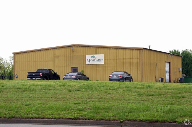

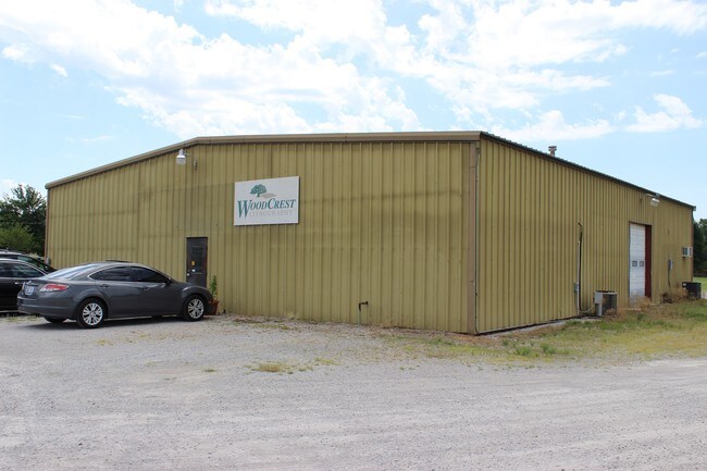
Property Detail
24814 E 71St St S
730007363
10-18-15 W 132'OF E 396' OF N 660' OF NE NW: W66' OF E 462' OF N 66O OF NE NW
Warehouse
Wagoner
B and X Area of moderate flood hazard, usually the area between the limits of the 100-year and 500-year floods.
Oklahoma
2025
3 AC
2025
Wagoner County
030509
Tulsa
4,500 SF
Tulsa, OK
NEARBY LISTINGS FOR SALE OR LEASE
-
-
View all Broken Arrow listings for sale on LoopNet.com
DEMOGRAPHICS near 24814 E 71St St S
1 mile
3 mile
5 mile
2025 Total Population
4,605
18,187
64,174
2030 Population
5,040
19,929
69,467
Pop Growth 2025-2030
+ 9.45%
+ 9.58%
+ 8.25%
Average Age
44
41
39
2025 Total Households
1,662
6,471
23,459
HH Growth 2025-2030
+ 9.15%
+ 9.27%
+ 7.95%
Median Household Inc
$109,917
$96,510
$91,086
Avg Household Size
2.70
2.80
2.70
2025 Avg HH Vehicles
2.00
2.00
2.00
Median Home Value
$329,036
$298,205
$267,013
Median Year Built
1997
2000
2002
Nearby Places
Map Layers
Map Styles
 Street
 Aerial
Layers
 Traffic
 Biking
Places
Listings with unknown addresses are not visible on the map
- Restaurants
- Banks
- Shops
- Fitness
- Groceries
PUBLIC TRANSPORTATION
AIRPORT
Tulsa International
Drive
Walk
Distance
Tulsa International
31 min
20.6 mi
SALE & LEASE HISTORY
LISTING DATE
SALE/LEASE

Sep 24, 2016
For Sale
Nearby Properties
Address
Land Use
TOTAL SIZE
Lot Size
Zoning
Address
Land Use
TOTAL SIZE
Lot Size
Zoning
5,920 SF
10.77 AC
Address
Land Use
TOTAL SIZE
Lot Size
Zoning
18,820 SF
13.42 AC
Address
Land Use
TOTAL SIZE
Lot Size
Zoning
7,200 SF
24.37 AC
Address
Land Use
TOTAL SIZE
Lot Size
Zoning
14,625 SF
42.36 AC
Address
Land Use
TOTAL SIZE
Lot Size
Zoning
Address
Land Use
TOTAL SIZE
Lot Size
Zoning
11,220 SF
8.58 AC
Address
Land Use
TOTAL SIZE
Lot Size
Zoning
319 SF
8.23 AC
Address
Land Use
TOTAL SIZE
Lot Size
Zoning
810 SF
56.20 AC
Address
Land Use
TOTAL SIZE
Lot Size
Zoning
1,080 SF
19.80 AC
Address
Land Use
TOTAL SIZE
Lot Size
Zoning
5,924 SF
135.96 AC
Address
Land Use
TOTAL SIZE
Lot Size
Zoning
16,790 SF
2.82 AC
Address
Land Use
TOTAL SIZE
Lot Size
Zoning
9,250 SF
6.89 AC
Address
Land Use
TOTAL SIZE
Lot Size
Zoning
1,500 SF
0.78 AC
Address
Land Use
TOTAL SIZE
Lot Size
Zoning
12,600 SF
6.97 AC
Address
Land Use
TOTAL SIZE
Lot Size
Zoning
1,446 SF
17.60 AC
Address
Land Use
TOTAL SIZE
Lot Size
Zoning
23,865 SF
2.50 AC
Address
Land Use
TOTAL SIZE
Lot Size
Zoning
6,336 SF
3.21 AC
Address
Land Use
TOTAL SIZE
Lot Size
Zoning
168 SF
17.77 AC
Address
Land Use
TOTAL SIZE
Lot Size
Zoning
27,966 SF
4.66 AC
Address
Land Use
TOTAL SIZE
Lot Size
Zoning
Address
Land Use
TOTAL SIZE
Lot Size
Zoning
18,900 SF
3.41 AC
Address
Land Use
TOTAL SIZE
Lot Size
Zoning
Address
Land Use
TOTAL SIZE
Lot Size
Zoning
10,773 SF
1.05 AC
Address
Land Use
TOTAL SIZE
Lot Size
Zoning
5,000 SF
10.89 AC
Address
Land Use
TOTAL SIZE
Lot Size
Zoning
216 SF
0.97 AC
Address
Land Use
TOTAL SIZE
Lot Size
Zoning
Address
Land Use
TOTAL SIZE
Lot Size
Zoning
4,858 SF
1.77 AC
Address
Land Use
TOTAL SIZE
Lot Size
Zoning
9,016 SF
Address
Land Use
TOTAL SIZE
Lot Size
Zoning
1,710 SF
0.81 AC
The World's #1 Commercial Real Estate Marketplace
Connect with us
© 2026 CoStar Group
The information above has been obtained from sources believed reliable. While we do not doubt its accuracy we have not verified it and make no guarantee, warranty or representation about it. It is your responsibility to independently confirm its accuracy and completeness. Any projections, opinions, assumptions, or estimates used are for example only and do not represent the current or future performance of the property. The value of this transaction to you depends on tax and other factors which should be evaluated by your tax, financial, and legal advisors. You and your advisors should conduct a careful, independent investigation of the property to determine to your satisfaction the suitability of the property for your needs.