Property Record
2483 Cedarcrest Rd, Acworth, GA 30101
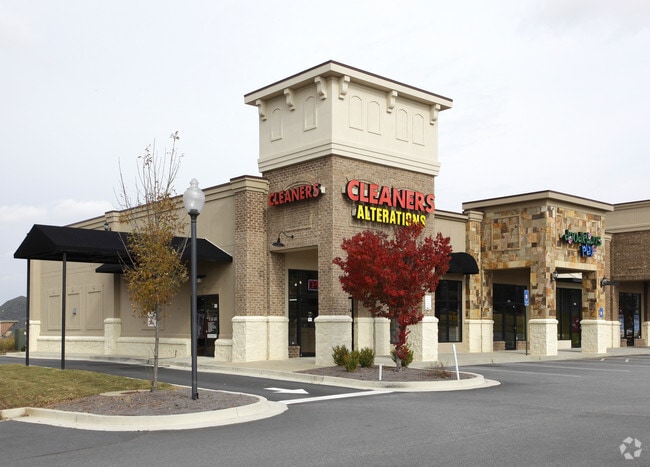


Property Detail
2483 Cedarcrest Rd
034.1.1.019.0000
REAL PROPERTY
Stripcommercialcenter
PAULDING
B1-100
Georgia
B and X Area of moderate flood hazard, usually the area between the limits of the 100-year and 500-year floods.
461
2025
0.53 AC
2025
Paulding Cnty/Dallas
120110
Atlanta
6,336 SF
Atlanta-Sandy Springs-Roswell, GA
NEARBY LISTINGS FOR SALE OR LEASE
DEMOGRAPHICS near 2483 Cedarcrest Rd
1 mile
3 mile
5 mile
2025 Total Population
6,596
33,839
71,282
2030 Population
7,218
37,229
77,341
Pop Growth 2025-2030
+ 9.43%
+ 10.02%
+ 8.50%
Average Age
37
38
38
2025 Total Households
2,011
10,484
22,579
HH Growth 2025-2030
+ 9.55%
+ 10.02%
+ 8.48%
Median Household Inc
$134,738
$130,631
$130,417
Avg Household Size
3.30
3.20
3.10
2025 Avg HH Vehicles
2.00
2.00
2.00
Median Home Value
$464,969
$435,296
$433,444
Median Year Built
2010
2007
2004
Nearby Places
Map Layers
Map Styles
 Street
 Aerial
Layers
 Traffic
 Biking
Places
Listings with unknown addresses are not visible on the map
- Restaurants
- Banks
- Shops
- Fitness
- Groceries
PUBLIC TRANSPORTATION
AIRPORT
Hartsfield - Jackson Atlanta International
Drive
Walk
Distance
Hartsfield - Jackson Atlanta International
66 min
45.4 mi
SALE & LEASE HISTORY
LISTING DATE
SALE/LEASE

Oct 07, 2016
For Lease
Nearby Properties
Address
Land Use
TOTAL SIZE
Lot Size
Zoning
Address
Land Use
TOTAL SIZE
Lot Size
Zoning
118.74 AC
Address
Land Use
TOTAL SIZE
Lot Size
Zoning
103.29 AC
PRD-100
Address
Land Use
TOTAL SIZE
Lot Size
Zoning
Address
Land Use
TOTAL SIZE
Lot Size
Zoning
Address
Land Use
TOTAL SIZE
Lot Size
Zoning
90.96 AC
Address
Land Use
TOTAL SIZE
Lot Size
Zoning
78,984 SF
17.01 AC
B1
Address
Land Use
TOTAL SIZE
Lot Size
Zoning
70,038 SF
8.67 AC
B2
Address
Land Use
TOTAL SIZE
Lot Size
Zoning
30,804 SF
2.29 AC
B2
Address
Land Use
TOTAL SIZE
Lot Size
Zoning
38,652 SF
1.07 AC
B1
Address
Land Use
TOTAL SIZE
Lot Size
Zoning
33,374 SF
5.69 AC
B1
Address
Land Use
TOTAL SIZE
Lot Size
Zoning
30,600 SF
4.28 AC
B2
Address
Land Use
TOTAL SIZE
Lot Size
Zoning
58,100 SF
6.74 AC
B2
Address
Land Use
TOTAL SIZE
Lot Size
Zoning
13,546 SF
1.49 AC
NB
Address
Land Use
TOTAL SIZE
Lot Size
Zoning
2,226 SF
10.61 AC
Address
Land Use
TOTAL SIZE
Lot Size
Zoning
17,253 SF
3.45 AC
B1
Address
Land Use
TOTAL SIZE
Lot Size
Zoning
16,250 SF
2.34 AC
B1
Address
Land Use
TOTAL SIZE
Lot Size
Zoning
80,550 SF
7.87 AC
B2
Address
Land Use
TOTAL SIZE
Lot Size
Zoning
32,223 SF
3.91 AC
B2
Address
Land Use
TOTAL SIZE
Lot Size
Zoning
17,610 SF
2.47 AC
B2
Address
Land Use
TOTAL SIZE
Lot Size
Zoning
20,940 SF
4.15 AC
B1
Address
Land Use
TOTAL SIZE
Lot Size
Zoning
14,438 SF
1.59 AC
B1
Address
Land Use
TOTAL SIZE
Lot Size
Zoning
17,538 SF
2.74 AC
B1
Address
Land Use
TOTAL SIZE
Lot Size
Zoning
11,042 SF
2 AC
B1
Address
Land Use
TOTAL SIZE
Lot Size
Zoning
10,720 SF
7.45 AC
B2-70
Address
Land Use
TOTAL SIZE
Lot Size
Zoning
150.55 AC
R2
Address
Land Use
TOTAL SIZE
Lot Size
Zoning
2,456 SF
258.38 AC
A1
Address
Land Use
TOTAL SIZE
Lot Size
Zoning
16,116 SF
1.64 AC
NB
Address
Land Use
TOTAL SIZE
Lot Size
Zoning
11,552 SF
1.37 AC
B2
Address
Land Use
TOTAL SIZE
Lot Size
Zoning
12,600 SF
1.50 AC
B1
Address
Land Use
TOTAL SIZE
Lot Size
Zoning
9,984 SF
1 AC
B1
The World's #1 Commercial Real Estate Marketplace
Connect with us
© 2026 CoStar Group
The information above has been obtained from sources believed reliable. While we do not doubt its accuracy we have not verified it and make no guarantee, warranty or representation about it. It is your responsibility to independently confirm its accuracy and completeness. Any projections, opinions, assumptions, or estimates used are for example only and do not represent the current or future performance of the property. The value of this transaction to you depends on tax and other factors which should be evaluated by your tax, financial, and legal advisors. You and your advisors should conduct a careful, independent investigation of the property to determine to your satisfaction the suitability of the property for your needs.