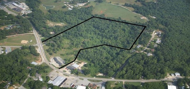
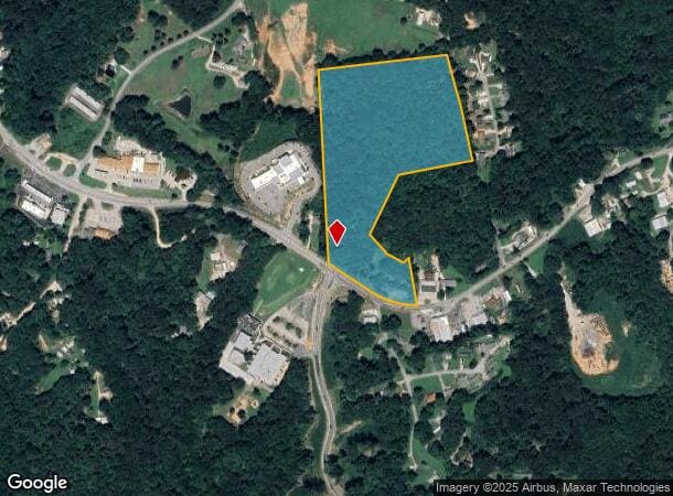
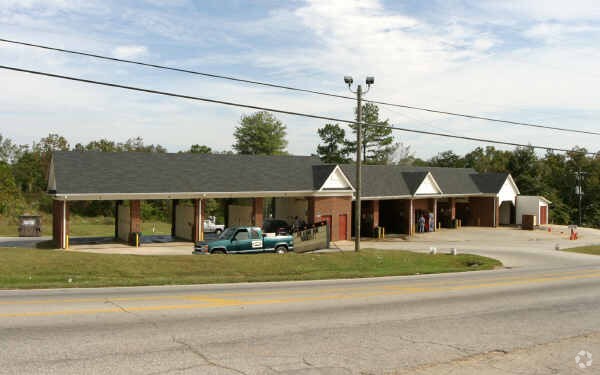
Property Record
2483 Old Cornelia Hwy, Gainesville, GA 30507

NEARBY LISTINGS FOR SALE OR LEASE
Property Detail
2483 Old Cornelia Hwy
Gainesville, GA
Jerry A Tipton A C&D Surv
15-0021B-00-066
Hall
Sfr
Georgia
X
17.97 AC
13139C0185H
Gainesville/Hall County
1,828 SF
Atlanta
DEMOGRAPHICS near 2483 Old Cornelia Hwy
1 Mile
3 Mile
5 Mile
2024 Total Population
1,047
19,917
51,837
2029 Population
1,157
22,063
57,295
Pop Growth 2024-2029
+ 10.51%
+ 10.77%
+ 10.53%
Average Age
40
38
37
2024 Total Households
359
6,910
17,411
HH Growth 2024-2029
+ 10.31%
+ 10.69%
+ 10.50%
Median Household Inc
$40,577
$50,575
$53,054
Avg Household Size
2.70
2.70
2.80
2024 Avg HH Vehicles
2.00
2.00
2.00
Median Home Value
$178,431
$192,659
$229,524
Median Year Built
1984
1988
1985
Nearby Places
Map Layers
Map Styles
 Street
 Aerial
- Restaurants
- Banks
- Shops
- Fitness
- Groceries
PUBLIC TRANSPORTATION
COMMUTER RAIL
Gainesville Amtrak Station (Crescent - Amtrak)
DRIVE
WALK
Distance
Gainesville Amtrak Station (Crescent - Amtrak)
7 min
3.9 mi
Freight Ports
Georgia Ports - Savannah
DRIVE
WALK
Distance
Georgia Ports - Savannah
319 min
253.4 mi
SALE & LEASE HISTORY
LISTING DATE
SALE/LEASE

Sep 24, 2016
For Sale
Oct 23, 2017
For Sale
Nearby Properties
Address
Land Use
TOTAL SIZE
Lot Size
Zoning
Address
Land Use
TOTAL SIZE
Lot Size
Zoning
564,132 SF
48.45 AC
PUD
Address
Land Use
TOTAL SIZE
Lot Size
Zoning
34,131 SF
80.82 AC
L-I
Address
Land Use
TOTAL SIZE
Lot Size
Zoning
39,637 SF
31.55 AC
R-II
Address
Land Use
TOTAL SIZE
Lot Size
Zoning
44,052 SF
19.19 AC
PUD
Address
Land Use
TOTAL SIZE
Lot Size
Zoning
237,470 SF
155.08 AC
L-I
Address
Land Use
TOTAL SIZE
Lot Size
Zoning
3,284 SF
28.53 AC
PUD
Address
Land Use
TOTAL SIZE
Lot Size
Zoning
2,038 SF
20.92 AC
R-II
Address
Land Use
TOTAL SIZE
Lot Size
Zoning
77,333 SF
11.74 AC
PUD
Address
Land Use
TOTAL SIZE
Lot Size
Zoning
46,795 SF
17.38 AC
PUD
Address
Land Use
TOTAL SIZE
Lot Size
Zoning
102,317 SF
6.90 AC
PUD
Address
Land Use
TOTAL SIZE
Lot Size
Zoning
128,531 SF
13.32 AC
R-I
Address
Land Use
TOTAL SIZE
Lot Size
Zoning
148,619 SF
30.75 AC
O-I
Address
Land Use
TOTAL SIZE
Lot Size
Zoning
25,386 SF
30.22 AC
AR-1
Address
Land Use
TOTAL SIZE
Lot Size
Zoning
140,805 SF
3.74 AC
PUD
Address
Land Use
TOTAL SIZE
Lot Size
Zoning
4,032 SF
89.43 AC
R-I
Address
Land Use
TOTAL SIZE
Lot Size
Zoning
467,600 SF
38.17 AC
L-I
Address
Land Use
TOTAL SIZE
Lot Size
Zoning
63,571 SF
31.97 AC
PUD
Address
Land Use
TOTAL SIZE
Lot Size
Zoning
82,610 SF
13.68 AC
G-B
Address
Land Use
TOTAL SIZE
Lot Size
Zoning
328,604 SF
10 AC
I-1
Address
Land Use
TOTAL SIZE
Lot Size
Zoning
69,888 SF
5.37 AC
O-I
Address
Land Use
TOTAL SIZE
Lot Size
Zoning
6.23 AC
R-II
Address
Land Use
TOTAL SIZE
Lot Size
Zoning
97,660 SF
7.17 AC
R-II
Address
Land Use
TOTAL SIZE
Lot Size
Zoning
194,850 SF
9.28 AC
L-I
Address
Land Use
TOTAL SIZE
Lot Size
Zoning
47,432 SF
15.80 AC
R-II
Address
Land Use
TOTAL SIZE
Lot Size
Zoning
28,059 SF
6.33 AC
AR-1
Address
Land Use
TOTAL SIZE
Lot Size
Zoning
1,440 SF
10.29 AC
R-II
Address
Land Use
TOTAL SIZE
Lot Size
Zoning
118,917 SF
14.81 AC
PUD
Address
Land Use
TOTAL SIZE
Lot Size
Zoning
11,448 SF
R-II
Address
Land Use
TOTAL SIZE
Lot Size
Zoning
1,348 SF
21.03 AC
AR-1
Address
Land Use
TOTAL SIZE
Lot Size
Zoning
69,888 SF
4.52 AC
O-I
The World's #1 Commercial Real Estate Marketplace
Connect with us
© 2025 CoStar Group
The information above has been obtained from sources believed reliable. While we do not doubt its accuracy we have not verified it and make no guarantee, warranty or representation about it. It is your responsibility to independently confirm its accuracy and completeness. Any projections, opinions, assumptions, or estimates used are for example only and do not represent the current or future performance of the property. The value of this transaction to you depends on tax and other factors which should be evaluated by your tax, financial, and legal advisors. You and your advisors should conduct a careful, independent investigation of the property to determine to your satisfaction the suitability of the property for your needs.