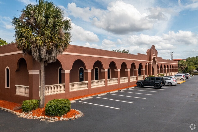
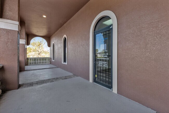
Property Record
2484 Caring Way, Port Charlotte, FL 33952


Current Lease Availabilities
NEARBY LISTINGS FOR SALE OR LEASE
Property Detail
2484 Caring Way
402215376003
Port Charlotte Plaza Section One
Medicalbuilding
15 40 22 P-10-3 1.5 AC. M/L COMM AT N R/W LN OF BRINSON AVE AND W R/W LN AARON ST W 398.14 FT FOR POB N 317.94 FT W 205.51 FT S 317.94 FT E 205.51 FT TO POB AKA PARCEL D 560/1557 868/38 1651/1807 1651/1809 2581/767 CT3911/2015 4104/882 50
AE
Charlotte
12015C0226G
Florida
2024
1.50 AC
2025
Charlotte County
020700
Southwest Florida
18,996 SF
Punta Gorda, FL
DEMOGRAPHICS near 2484 Caring Way
1 Mile
3 Mile
5 Mile
2024 Total Population
10,950
54,544
92,460
2029 Population
12,995
64,726
109,910
Pop Growth 2024-2029
+ 18.68%
+ 18.67%
+ 18.87%
Average Age
47
48
50
2024 Total Households
4,928
23,673
40,678
HH Growth 2024-2029
+ 19.09%
+ 19.00%
+ 19.26%
Median Household Inc
$34,252
$54,208
$57,088
Avg Household Size
2.10
2.20
2.20
2024 Avg HH Vehicles
1.00
2.00
2.00
Median Home Value
$146,802
$208,035
$232,698
Median Year Built
1973
1981
1986
Nearby Places
- Restaurants
- Banks
- Shops
- Fitness
- Groceries
PUBLIC TRANSPORTATION
AIRPORT
Punta Gorda
DRIVE
WALK
Distance
Punta Gorda
19 min
9.6 mi
Freight Ports
Port Manatee
DRIVE
WALK
Distance
Port Manatee
84 min
66.0 mi
Nearby Properties
Address
Land Use
TOTAL SIZE
Lot Size
Zoning
Address
Land Use
TOTAL SIZE
Lot Size
Zoning
156,350 SF
12.49 AC
OMI
Address
Land Use
TOTAL SIZE
Lot Size
Zoning
129,475 SF
16.04 AC
OMI
Address
Land Use
TOTAL SIZE
Lot Size
Zoning
53,564 SF
22 AC
PD
Address
Land Use
TOTAL SIZE
Lot Size
Zoning
172,298 SF
37.42 AC
OMI
Address
Land Use
TOTAL SIZE
Lot Size
Zoning
789,392 SF
31.39 AC
RMF15
Address
Land Use
TOTAL SIZE
Lot Size
Zoning
196,676 SF
30 AC
OMI
Address
Land Use
TOTAL SIZE
Lot Size
Zoning
174,965 SF
13.52 AC
CG
Address
Land Use
TOTAL SIZE
Lot Size
Zoning
238,852 SF
26.63 AC
CG
Address
Land Use
TOTAL SIZE
Lot Size
Zoning
119,749 SF
12.90 AC
RSF3.5
Address
Land Use
TOTAL SIZE
Lot Size
Zoning
208,372 SF
21.98 AC
II
Address
Land Use
TOTAL SIZE
Lot Size
Zoning
122,030 SF
7.43 AC
CG
Address
Land Use
TOTAL SIZE
Lot Size
Zoning
40,430 SF
5.63 AC
RMF12
Address
Land Use
TOTAL SIZE
Lot Size
Zoning
141,647 SF
20.29 AC
CG
Address
Land Use
TOTAL SIZE
Lot Size
Zoning
128,594 SF
25.54 AC
PD
Address
Land Use
TOTAL SIZE
Lot Size
Zoning
70,518 SF
2.08 AC
PD
Address
Land Use
TOTAL SIZE
Lot Size
Zoning
102,337 SF
10.43 AC
RSF3.5
Address
Land Use
TOTAL SIZE
Lot Size
Zoning
98,599 SF
9.75 AC
CG
Address
Land Use
TOTAL SIZE
Lot Size
Zoning
107,237 SF
20.14 AC
CG
Address
Land Use
TOTAL SIZE
Lot Size
Zoning
91,281 SF
10 AC
CG
Address
Land Use
TOTAL SIZE
Lot Size
Zoning
50,970 SF
9.74 AC
RSF3.5
Address
Land Use
TOTAL SIZE
Lot Size
Zoning
96,253 SF
7.89 AC
CG
Address
Land Use
TOTAL SIZE
Lot Size
Zoning
37,045 SF
21.20 AC
PD
Address
Land Use
TOTAL SIZE
Lot Size
Zoning
88,259 SF
4.71 AC
CG
Address
Land Use
TOTAL SIZE
Lot Size
Zoning
12,101 SF
15.92 AC
ES
Address
Land Use
TOTAL SIZE
Lot Size
Zoning
135,717 SF
10.55 AC
CG
Address
Land Use
TOTAL SIZE
Lot Size
Zoning
1,296 SF
14.46 AC
CG
Address
Land Use
TOTAL SIZE
Lot Size
Zoning
34,975 SF
2.90 AC
RMF15
Address
Land Use
TOTAL SIZE
Lot Size
Zoning
82,800 SF
9.45 AC
CG
Address
Land Use
TOTAL SIZE
Lot Size
Zoning
35,587 SF
6.27 AC
RMF15
Address
Land Use
TOTAL SIZE
Lot Size
Zoning
22,919 SF
4.70 AC
CG
The World's #1 Commercial Real Estate Marketplace
Connect with us
© 2025 CoStar Group
The information above has been obtained from sources believed reliable. While we do not doubt its accuracy we have not verified it and make no guarantee, warranty or representation about it. It is your responsibility to independently confirm its accuracy and completeness. Any projections, opinions, assumptions, or estimates used are for example only and do not represent the current or future performance of the property. The value of this transaction to you depends on tax and other factors which should be evaluated by your tax, financial, and legal advisors. You and your advisors should conduct a careful, independent investigation of the property to determine to your satisfaction the suitability of the property for your needs.