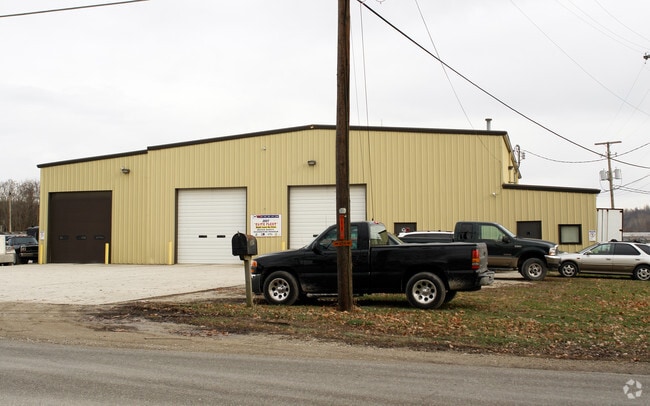
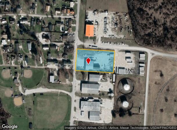
Property Record
2485 County Road 1, South Point, OH 45680

NEARBY LISTINGS FOR SALE OR LEASE
Property Detail
2485 County Road 1
15-123-0200-006
South Point Delta
Commercialnec
17-2-29 PT S PT N1/2 SEC NEXT TO CR PT LESS 0.31 BAL = 2.10ACRES
X
Lawrence
21019C0078E
Ohio
0
2.10 AC
2024
Lawrence County
051002
Huntington/Ashland
7,496 SF
Huntington-Ashland, WV-KY-OH
DEMOGRAPHICS near 2485 County Road 1
1 Mile
3 Mile
5 Mile
2024 Total Population
2,328
21,430
46,766
2029 Population
2,283
21,064
45,877
Pop Growth 2024-2029
(1.93%)
(1.71%)
(1.90%)
Average Age
39
41
42
2024 Total Households
970
8,933
19,574
HH Growth 2024-2029
(1.75%)
(1.62%)
(1.82%)
Median Household Inc
$30,921
$46,810
$46,764
Avg Household Size
2.40
2.30
2.30
2024 Avg HH Vehicles
2.00
2.00
2.00
Median Home Value
$82,084
$117,313
$119,443
Median Year Built
1974
1967
1967
Nearby Places
Map Layers
Map Styles
 Street
 Aerial
- Restaurants
- Banks
- Shops
- Fitness
- Groceries
PUBLIC TRANSPORTATION
COMMUTER RAIL
Ashland Amtrak Station (Cardinal - Amtrak)
DRIVE
WALK
Distance
Ashland Amtrak Station (Cardinal - Amtrak)
9 min
5.6 mi
AIRPORT
Tri-State/Milton J Ferguson Field
DRIVE
WALK
Distance
Tri-State/Milton J Ferguson Field
26 min
18.3 mi
Freight Ports
Port of Toledo
DRIVE
WALK
Distance
Port of Toledo
338 min
261.5 mi
SALE & LEASE HISTORY
LISTING DATE
SALE/LEASE

Aug 12, 2019
For Lease
Nearby Properties
Address
Land Use
TOTAL SIZE
Lot Size
Zoning
Address
Land Use
TOTAL SIZE
Lot Size
Zoning
116,640 SF
0.97 AC
COMMERCIAL
Address
Land Use
TOTAL SIZE
Lot Size
Zoning
123,920 SF
6.81 AC
Address
Land Use
TOTAL SIZE
Lot Size
Zoning
141 AC
COMMERCIAL
Address
Land Use
TOTAL SIZE
Lot Size
Zoning
47,107 SF
4.67 AC
Address
Land Use
TOTAL SIZE
Lot Size
Zoning
8,364 SF
3 AC
Z02
Address
Land Use
TOTAL SIZE
Lot Size
Zoning
1.46 AC
COMMERCIAL
Address
Land Use
TOTAL SIZE
Lot Size
Zoning
3.50 AC
Z02
Address
Land Use
TOTAL SIZE
Lot Size
Zoning
1,920 SF
33.30 AC
Z03
Address
Land Use
TOTAL SIZE
Lot Size
Zoning
126,716 SF
10.60 AC
Address
Land Use
TOTAL SIZE
Lot Size
Zoning
54.65 AC
Address
Land Use
TOTAL SIZE
Lot Size
Zoning
66,600 SF
1.35 AC
OTHER
Address
Land Use
TOTAL SIZE
Lot Size
Zoning
4 AC
Z01
Address
Land Use
TOTAL SIZE
Lot Size
Zoning
96,405 SF
1.40 AC
COMMERCIAL
Address
Land Use
TOTAL SIZE
Lot Size
Zoning
1.60 AC
COMMERCIAL
Address
Land Use
TOTAL SIZE
Lot Size
Zoning
27,084 SF
3.73 AC
Address
Land Use
TOTAL SIZE
Lot Size
Zoning
4,824 SF
2.83 AC
OTHER
Address
Land Use
TOTAL SIZE
Lot Size
Zoning
68,160 SF
0.87 AC
Z01
Address
Land Use
TOTAL SIZE
Lot Size
Zoning
0.57 AC
RESIDENTIA
Address
Land Use
TOTAL SIZE
Lot Size
Zoning
2.99 AC
RESIDENTIA
Address
Land Use
TOTAL SIZE
Lot Size
Zoning
43.18 AC
COMMERCIAL
Address
Land Use
TOTAL SIZE
Lot Size
Zoning
11.96 AC
Address
Land Use
TOTAL SIZE
Lot Size
Zoning
0.69 AC
COMMERCIAL
Address
Land Use
TOTAL SIZE
Lot Size
Zoning
0.87 AC
RESIDENTIA
Address
Land Use
TOTAL SIZE
Lot Size
Zoning
3,273 SF
0.41 AC
COMMERCIAL
Address
Land Use
TOTAL SIZE
Lot Size
Zoning
75,900 SF
6.04 AC
Address
Land Use
TOTAL SIZE
Lot Size
Zoning
0.27 AC
Z02
Address
Land Use
TOTAL SIZE
Lot Size
Zoning
0.98 AC
COMMERCIAL
Address
Land Use
TOTAL SIZE
Lot Size
Zoning
4.55 AC
COMMERCIAL
Address
Land Use
TOTAL SIZE
Lot Size
Zoning
0.49 AC
Address
Land Use
TOTAL SIZE
Lot Size
Zoning
2.78 AC
Z01
The World's #1 Commercial Real Estate Marketplace
Connect with us
© 2025 CoStar Group
The information above has been obtained from sources believed reliable. While we do not doubt its accuracy we have not verified it and make no guarantee, warranty or representation about it. It is your responsibility to independently confirm its accuracy and completeness. Any projections, opinions, assumptions, or estimates used are for example only and do not represent the current or future performance of the property. The value of this transaction to you depends on tax and other factors which should be evaluated by your tax, financial, and legal advisors. You and your advisors should conduct a careful, independent investigation of the property to determine to your satisfaction the suitability of the property for your needs.