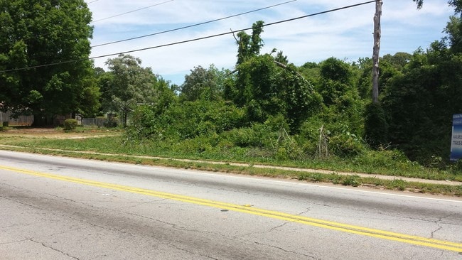
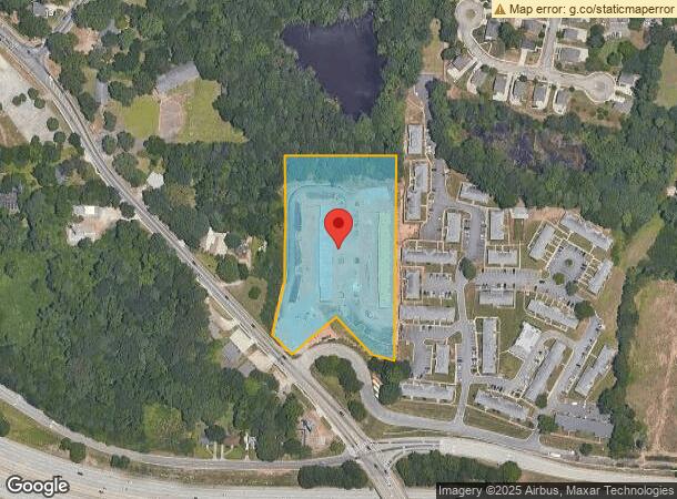
Property Record
2486 Flat Shoals Rd, Decatur, GA 30032
NEARBY LISTINGS FOR SALE OR LEASE
Property Detail
2486 Flat Shoals Rd
15-140-03-016
92 X 150 X 35 X 145 X 201 X 77 X 192 X 331 X 592 3.16AC 8-23-91
Apartment
DeKalb
X
Georgia
13089C0133J
16
2025
3.99 AC
2025
I-20 East/Conyers
023101
Atlanta
59,246 SF
Atlanta-Sandy Springs-Roswell, GA
DEMOGRAPHICS near 2486 Flat Shoals Rd
1 Mile
3 Mile
5 Mile
2024 Total Population
10,314
83,091
260,938
2029 Population
10,203
83,779
265,223
Pop Growth 2024-2029
(1.08%)
+ 0.83%
+ 1.64%
Average Age
40
39
38
2024 Total Households
4,260
34,246
110,737
HH Growth 2024-2029
(1.13%)
+ 0.85%
+ 1.87%
Median Household Inc
$50,515
$63,287
$74,746
Avg Household Size
2.40
2.30
2.30
2024 Avg HH Vehicles
2.00
2.00
2.00
Median Home Value
$259,241
$337,727
$359,228
Median Year Built
1968
1968
1976
Nearby Places
Map Layers
Map Styles
 Street
 Aerial
- Restaurants
- Banks
- Shops
- Fitness
- Groceries
PUBLIC TRANSPORTATION
AIRPORT
Hartsfield - Jackson Atlanta International
DRIVE
WALK
Distance
Hartsfield - Jackson Atlanta International
22 min
11.6 mi
Freight Ports
Georgia Ports - Savannah
DRIVE
WALK
Distance
Georgia Ports - Savannah
275 min
243.4 mi
SALE & LEASE HISTORY
LISTING DATE
SALE/LEASE

Sep 24, 2016
For Sale
Jun 04, 2018
For Sale
Nearby Properties
Address
Land Use
TOTAL SIZE
Lot Size
Zoning
Address
Land Use
TOTAL SIZE
Lot Size
Zoning
432,056 SF
17.87 AC
C1
Address
Land Use
TOTAL SIZE
Lot Size
Zoning
290,130 SF
6.13 AC
R100
Address
Land Use
TOTAL SIZE
Lot Size
Zoning
67,882 SF
4.77 AC
X
Address
Land Use
TOTAL SIZE
Lot Size
Zoning
81,129 SF
4.29 AC
C1
Address
Land Use
TOTAL SIZE
Lot Size
Zoning
76,654 SF
3.14 AC
C-1
Address
Land Use
TOTAL SIZE
Lot Size
Zoning
105,624 SF
11.62 AC
MR-2
Address
Land Use
TOTAL SIZE
Lot Size
Zoning
381,983 SF
52.54 AC
M
Address
Land Use
TOTAL SIZE
Lot Size
Zoning
91,622 SF
18.99 AC
X
Address
Land Use
TOTAL SIZE
Lot Size
Zoning
522,850 SF
41.34 AC
RM75
Address
Land Use
TOTAL SIZE
Lot Size
Zoning
278,121 SF
20 AC
RM85
Address
Land Use
TOTAL SIZE
Lot Size
Zoning
72,870 SF
12.34 AC
C2
Address
Land Use
TOTAL SIZE
Lot Size
Zoning
137,771 SF
1.53 AC
RM75
Address
Land Use
TOTAL SIZE
Lot Size
Zoning
245,053 SF
22.77 AC
RM85
Address
Land Use
TOTAL SIZE
Lot Size
Zoning
74,593 SF
2.16 AC
NC1
Address
Land Use
TOTAL SIZE
Lot Size
Zoning
13,114 SF
17.54 AC
RM100
Address
Land Use
TOTAL SIZE
Lot Size
Zoning
295,632 SF
19.26 AC
RM75
Address
Land Use
TOTAL SIZE
Lot Size
Zoning
40,809 SF
2.37 AC
C-1
Address
Land Use
TOTAL SIZE
Lot Size
Zoning
151,107 SF
X
Address
Land Use
TOTAL SIZE
Lot Size
Zoning
381,923 SF
19.72 AC
M
Address
Land Use
TOTAL SIZE
Lot Size
Zoning
235,787 SF
15.43 AC
RM100
Address
Land Use
TOTAL SIZE
Lot Size
Zoning
554,853 SF
42.64 AC
RM75
Address
Land Use
TOTAL SIZE
Lot Size
Zoning
419,434 SF
21.59 AC
RM85
Address
Land Use
TOTAL SIZE
Lot Size
Zoning
219,652 SF
27.08 AC
C1
Address
Land Use
TOTAL SIZE
Lot Size
Zoning
375,336 SF
22.76 AC
M
Address
Land Use
TOTAL SIZE
Lot Size
Zoning
132,604 SF
19.12 AC
RM100
Address
Land Use
TOTAL SIZE
Lot Size
Zoning
146,133 SF
16.10 AC
RM75
Address
Land Use
TOTAL SIZE
Lot Size
Zoning
367,452 SF
30.89 AC
RM100
Address
Land Use
TOTAL SIZE
Lot Size
Zoning
150,899 SF
21.89 AC
X
Address
Land Use
TOTAL SIZE
Lot Size
Zoning
217,904 SF
14.84 AC
The World's #1 Commercial Real Estate Marketplace
Connect with us
© 2026 CoStar Group
The information above has been obtained from sources believed reliable. While we do not doubt its accuracy we have not verified it and make no guarantee, warranty or representation about it. It is your responsibility to independently confirm its accuracy and completeness. Any projections, opinions, assumptions, or estimates used are for example only and do not represent the current or future performance of the property. The value of this transaction to you depends on tax and other factors which should be evaluated by your tax, financial, and legal advisors. You and your advisors should conduct a careful, independent investigation of the property to determine to your satisfaction the suitability of the property for your needs.