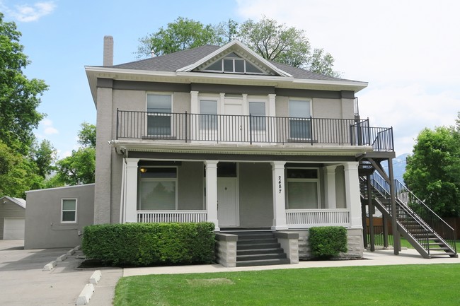
Property Record
2487 S 700 E, Salt Lake City, UT 84106


NEARBY LISTINGS FOR SALE OR LEASE
Property Detail
2487 S 700 E
Salt Lake City, UT
Ten Acre Plat A Big Field Survey
16-20-304-009-0000
COM N 0^1318 E 1334.5 FT FR SW COR BLK 44 10 AC PLAT A BIGFIELD SUR N 0^1218 E 140 FT N 89^5136 E 214.5 FT S 0^1846 W 75.2 FT S 89^5136 W 63.95 FT S 0^1846 W 64.8 FT S 89^5136 W 150 FT TO BEG 5730-937 5730-0939 5746-2986 6416-0371 6599-2247 7231-0476
Hospitalprivate
Salt Lake
X
Utah
49035C0303G
4
0
0.59 AC
2025
Sugarhouse
104900
Salt Lake City
9,526 SF
DEMOGRAPHICS near 2487 S 700 E
1 Mile
3 Mile
5 Mile
2024 Total Population
22,414
152,790
360,592
2029 Population
22,746
154,684
365,306
Pop Growth 2024-2029
+ 1.48%
+ 1.24%
+ 1.31%
Average Age
38
37
37
2024 Total Households
10,466
65,560
149,854
HH Growth 2024-2029
+ 1.69%
+ 1.37%
+ 1.59%
Median Household Inc
$67,805
$68,323
$66,985
Avg Household Size
2.00
2.20
2.30
2024 Avg HH Vehicles
2.00
2.00
2.00
Median Home Value
$444,382
$497,905
$486,252
Median Year Built
1966
1965
1972
Nearby Places
Map Layers
Map Styles
 Street
 Aerial
- Restaurants
- Banks
- Shops
- Fitness
- Groceries
PUBLIC TRANSPORTATION
TRANSIT/SUBWAY
700 East Station (S-Line - Utah Transit Authority (UTA))
DRIVE
WALK
Distance
700 East Station (S-Line - Utah Transit Authority (UTA))
1 min
8 min
0.5 mi
500 East Station (S-Line - Utah Transit Authority (UTA))
DRIVE
WALK
Distance
500 East Station (S-Line - Utah Transit Authority (UTA))
2 min
14 min
0.7 mi
Sugarmont Station (S-Line - Utah Transit Authority (UTA))
DRIVE
WALK
Distance
Sugarmont Station (S-Line - Utah Transit Authority (UTA))
2 min
14 min
0.7 mi
Fairmont Station (S-Line - Utah Transit Authority (UTA))
DRIVE
WALK
Distance
Fairmont Station (S-Line - Utah Transit Authority (UTA))
2 min
17 min
0.9 mi
300 East Station (S-Line - Utah Transit Authority (UTA))
DRIVE
WALK
Distance
300 East Station (S-Line - Utah Transit Authority (UTA))
3 min
19 min
1.0 mi
COMMUTER RAIL
North Temple Station (FrontRunner - Utah Transit Authority (UTA))
DRIVE
WALK
Distance
North Temple Station (FrontRunner - Utah Transit Authority (UTA))
10 min
6.2 mi
Warm Springs Relief Point (FrontRunner - Utah Transit Authority (UTA))
DRIVE
WALK
Distance
Warm Springs Relief Point (FrontRunner - Utah Transit Authority (UTA))
11 min
7.6 mi
AIRPORT
Salt Lake City International
DRIVE
WALK
Distance
Salt Lake City International
14 min
10.2 mi
Freight Ports
Port of Stockton
DRIVE
WALK
Distance
Port of Stockton
714 min
700.6 mi
SALE & LEASE HISTORY
LISTING DATE
SALE/LEASE

Sep 24, 2016
For Sale
Nearby Properties
Address
Land Use
TOTAL SIZE
Lot Size
Zoning
Address
Land Use
TOTAL SIZE
Lot Size
Zoning
298,628 SF
27.30 AC
I
Address
Land Use
TOTAL SIZE
Lot Size
Zoning
488,509 SF
36.03 AC
FLEX
Address
Land Use
TOTAL SIZE
Lot Size
Zoning
163,932 SF
14.65 AC
PL
Address
Land Use
TOTAL SIZE
Lot Size
Zoning
691,463 SF
17.80 AC
RM
Address
Land Use
TOTAL SIZE
Lot Size
Zoning
208,868 SF
20.41 AC
I
Address
Land Use
TOTAL SIZE
Lot Size
Zoning
128,997 SF
3.04 AC
ESN
Address
Land Use
TOTAL SIZE
Lot Size
Zoning
521,964 SF
3.23 AC
T-O-D
Address
Land Use
TOTAL SIZE
Lot Size
Zoning
297,476 SF
1.62 AC
CSHBD2
Address
Land Use
TOTAL SIZE
Lot Size
Zoning
549,074 SF
3.45 AC
D-1
Address
Land Use
TOTAL SIZE
Lot Size
Zoning
369,717 SF
2.50 AC
RO
Address
Land Use
TOTAL SIZE
Lot Size
Zoning
502,104 SF
4.11 AC
E ST C
Address
Land Use
TOTAL SIZE
Lot Size
Zoning
412,006 SF
1.70 AC
C3
Address
Land Use
TOTAL SIZE
Lot Size
Zoning
371,963 SF
1.81 AC
R-MU
Address
Land Use
TOTAL SIZE
Lot Size
Zoning
369,377 SF
1.65 AC
Address
Land Use
TOTAL SIZE
Lot Size
Zoning
426,600 SF
1.61 AC
CSHBD1
Address
Land Use
TOTAL SIZE
Lot Size
Zoning
95,854 SF
15.42 AC
CC
Address
Land Use
TOTAL SIZE
Lot Size
Zoning
903,167 SF
1.90 AC
CSHBD1
Address
Land Use
TOTAL SIZE
Lot Size
Zoning
125,518 SF
11.03 AC
RMZC
Address
Land Use
TOTAL SIZE
Lot Size
Zoning
191,876 SF
3.18 AC
TSAUNC
Address
Land Use
TOTAL SIZE
Lot Size
Zoning
33,164 SF
6.88 AC
RM
Address
Land Use
TOTAL SIZE
Lot Size
Zoning
84,870 SF
9.76 AC
MPMU
Address
Land Use
TOTAL SIZE
Lot Size
Zoning
347,330 SF
6.91 AC
CC
Address
Land Use
TOTAL SIZE
Lot Size
Zoning
107,416 SF
5.46 AC
CSHBD2
Address
Land Use
TOTAL SIZE
Lot Size
Zoning
217,700 SF
52.59 AC
FLEX
Address
Land Use
TOTAL SIZE
Lot Size
Zoning
296,854 SF
10.97 AC
1205
Address
Land Use
TOTAL SIZE
Lot Size
Zoning
56,867 SF
5.33 AC
MIXED
Address
Land Use
TOTAL SIZE
Lot Size
Zoning
303,240 SF
29.21 AC
1205
Address
Land Use
TOTAL SIZE
Lot Size
Zoning
335,747 SF
2.22 AC
D2
Address
Land Use
TOTAL SIZE
Lot Size
Zoning
80,985 SF
19.18 AC
RM
Address
Land Use
TOTAL SIZE
Lot Size
Zoning
388,498 SF
10.18 AC
CS
The World's #1 Commercial Real Estate Marketplace
Connect with us
© 2026 CoStar Group
The information above has been obtained from sources believed reliable. While we do not doubt its accuracy we have not verified it and make no guarantee, warranty or representation about it. It is your responsibility to independently confirm its accuracy and completeness. Any projections, opinions, assumptions, or estimates used are for example only and do not represent the current or future performance of the property. The value of this transaction to you depends on tax and other factors which should be evaluated by your tax, financial, and legal advisors. You and your advisors should conduct a careful, independent investigation of the property to determine to your satisfaction the suitability of the property for your needs.