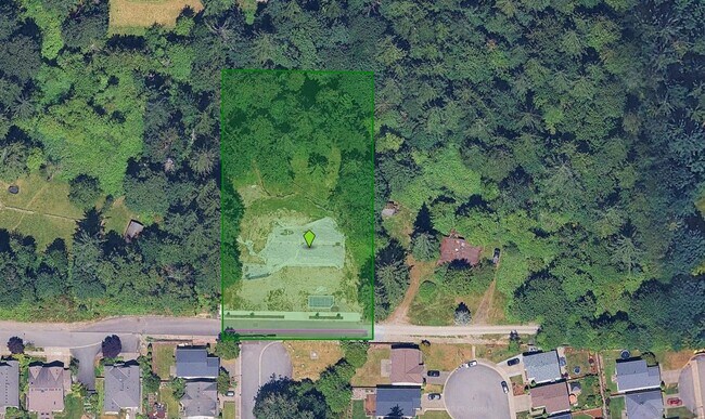
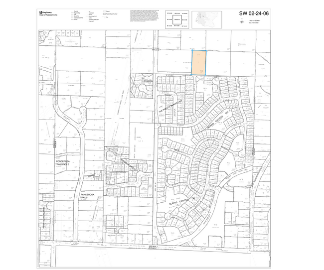
Property Record
24892 Se 17Th St, Sammamish, WA 98075
NEARBY LISTINGS FOR SALE OR LEASE
-
-
View all Sammamish listings for sale on LoopNet.com
Property Detail
24892 Se 17Th St
022406-9105
B
Residentialacreage
LOT 2 TGW UND INT IN TR A OF SAMMAMISH SP #FSHP2023-00045 REC #20230330900010 SD SP LOC IN NE 1/4 OF SW 1/4 STR 02-24-06
X
King
53033C0685G
Washington
2025
E King County
2024
Seattle/Puget Sound
032215
Seattle-Tacoma-Bellevue, WA
DEMOGRAPHICS near 24892 Se 17Th St
1 Mile
3 Mile
5 Mile
2024 Total Population
7,245
60,373
111,711
2029 Population
7,173
59,759
110,686
Pop Growth 2024-2029
(0.99%)
(1.02%)
(0.92%)
Average Age
38
39
39
2024 Total Households
2,207
20,101
38,981
HH Growth 2024-2029
(1.13%)
(1.22%)
(1.11%)
Median Household Inc
$239,724
$222,050
$204,121
Avg Household Size
3.20
3.00
2.80
2024 Avg HH Vehicles
2.00
2.00
2.00
Median Home Value
$1,109,454
$1,089,585
$1,088,086
Median Year Built
2000
1995
1995
Nearby Places
Map Layers
Map Styles
 Street
 Aerial
- Restaurants
- Banks
- Shops
- Fitness
- Groceries
PUBLIC TRANSPORTATION
AIRPORT
Seattle-Tacoma International
DRIVE
WALK
Distance
Seattle-Tacoma International
43 min
26.7 mi
Seattle Paine Field International
DRIVE
WALK
Distance
Seattle Paine Field International
51 min
31.0 mi
Freight Ports
Port of Seattle
DRIVE
WALK
Distance
Port of Seattle
38 min
23.3 mi
Nearby Properties
Address
Land Use
TOTAL SIZE
Lot Size
Zoning
Address
Land Use
TOTAL SIZE
Lot Size
Zoning
411,348 SF
11.65 AC
R18
Address
Land Use
TOTAL SIZE
Lot Size
Zoning
249,508 SF
14.79 AC
R18
Address
Land Use
TOTAL SIZE
Lot Size
Zoning
190,900 SF
15.71 AC
R12
Address
Land Use
TOTAL SIZE
Lot Size
Zoning
145,000 SF
34.09 AC
R4
Address
Land Use
TOTAL SIZE
Lot Size
Zoning
103,682 SF
39.46 AC
R1
Address
Land Use
TOTAL SIZE
Lot Size
Zoning
82,863 SF
4.23 AC
CB
Address
Land Use
TOTAL SIZE
Lot Size
Zoning
161,566 SF
20.76 AC
R6
Address
Land Use
TOTAL SIZE
Lot Size
Zoning
78,384 SF
2.34 AC
TC A2
Address
Land Use
TOTAL SIZE
Lot Size
Zoning
53,500 SF
32.68 AC
R6
Address
Land Use
TOTAL SIZE
Lot Size
Zoning
87,600 SF
5.56 AC
SF-SL
Address
Land Use
TOTAL SIZE
Lot Size
Zoning
105,240 SF
43.38 AC
RA5P
Address
Land Use
TOTAL SIZE
Lot Size
Zoning
28,106 SF
28.86 AC
CF-F
Address
Land Use
TOTAL SIZE
Lot Size
Zoning
143.99 AC
CF-F
Address
Land Use
TOTAL SIZE
Lot Size
Zoning
68,000 SF
9.37 AC
TC D
Address
Land Use
TOTAL SIZE
Lot Size
Zoning
208,733 SF
5.17 AC
R4
Address
Land Use
TOTAL SIZE
Lot Size
Zoning
1,030 SF
120.43 AC
RA5P
Address
Land Use
TOTAL SIZE
Lot Size
Zoning
105,386 SF
19.50 AC
R6
Address
Land Use
TOTAL SIZE
Lot Size
Zoning
72,764 SF
13.50 AC
R1
Address
Land Use
TOTAL SIZE
Lot Size
Zoning
64,589 SF
10.90 AC
R6
Address
Land Use
TOTAL SIZE
Lot Size
Zoning
88,711 SF
4.97 AC
MF-H
Address
Land Use
TOTAL SIZE
Lot Size
Zoning
56,506 SF
7.17 AC
R6
Address
Land Use
TOTAL SIZE
Lot Size
Zoning
56,206 SF
18.69 AC
R4
Address
Land Use
TOTAL SIZE
Lot Size
Zoning
7,015 SF
4.95 AC
O
Address
Land Use
TOTAL SIZE
Lot Size
Zoning
55,515 SF
18.86 AC
RA5P
Address
Land Use
TOTAL SIZE
Lot Size
Zoning
43,320 SF
2.77 AC
TC B
Address
Land Use
TOTAL SIZE
Lot Size
Zoning
61,960 SF
7.95 AC
TC D
Address
Land Use
TOTAL SIZE
Lot Size
Zoning
10.08 AC
R18
Address
Land Use
TOTAL SIZE
Lot Size
Zoning
32,171 SF
4.32 AC
CB
Address
Land Use
TOTAL SIZE
Lot Size
Zoning
26,395 SF
2.91 AC
CB
The World's #1 Commercial Real Estate Marketplace
Connect with us
© 2025 CoStar Group
The information above has been obtained from sources believed reliable. While we do not doubt its accuracy we have not verified it and make no guarantee, warranty or representation about it. It is your responsibility to independently confirm its accuracy and completeness. Any projections, opinions, assumptions, or estimates used are for example only and do not represent the current or future performance of the property. The value of this transaction to you depends on tax and other factors which should be evaluated by your tax, financial, and legal advisors. You and your advisors should conduct a careful, independent investigation of the property to determine to your satisfaction the suitability of the property for your needs.