Property Record
249 Brigantine Dunmore Rd, Midway, GA 31320

Save to a Folder
{{folder.Name}}
{{folder.ListingIds.length}} Properties
{{folder.ListingIds.length}} Property
Create a New Folder
Property Detail
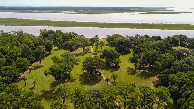
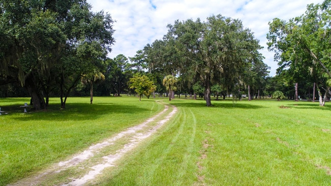
249 Brigantine Dunmore Rd
347C-001
10.57 AC E/S BRIGANTINE DUNMORE RD
Residentialacreage
LIBERTY
R12
Georgia
AE The base floodplain where base flood elevations are provided. AE Zones are now used on new format FIRMs instead of A1-A30 Zones.
9.37 AC
2025
Liberty County
2025
Savannah
010501
Hinesville, GA
513 SF
NEARBY LISTINGS FOR SALE OR LEASE
-
-
View all Midway listings for sale on LoopNet.com
DEMOGRAPHICS near 249 Brigantine Dunmore Rd
1 mile
3 mile
5 mile
2025 Total Population
314
997
5,175
2030 Population
335
1,090
5,673
Pop Growth 2025-2030
+ 6.69%
+ 9.33%
+ 9.62%
Average Age
44
41
40
2025 Total Households
133
379
1,897
HH Growth 2025-2030
+ 6.77%
+ 8.97%
+ 9.33%
Median Household Inc
$64,411
$116,553
$126,562
Avg Household Size
2.30
2.60
2.70
2025 Avg HH Vehicles
2.00
2.00
2.00
Median Home Value
$355,882
$457,534
$465,487
Median Year Built
1998
2005
2005
Nearby Places
Map Layers
Map Styles
 Street
 Aerial
Layers
 Traffic
 Biking
Places
Listings with unknown addresses are not visible on the map
- Restaurants
- Banks
- Shops
- Fitness
- Groceries
PUBLIC TRANSPORTATION
AIRPORT
Savannah/Hilton Head International
Drive
Walk
Distance
Savannah/Hilton Head International
55 min
37.3 mi
SALE & LEASE HISTORY
LISTING DATE
SALE/LEASE

Jun 02, 2024
For Sale
Dec 16, 2019
For Sale
Apr 10, 2020
For Sale
Nearby Properties
Address
Land Use
TOTAL SIZE
Lot Size
Zoning
Address
Land Use
TOTAL SIZE
Lot Size
Zoning
258,258 SF
44.73 AC
I1
Address
Land Use
TOTAL SIZE
Lot Size
Zoning
2,677.29 AC
A1
Address
Land Use
TOTAL SIZE
Lot Size
Zoning
6,086 SF
5.54 AC
A1
Address
Land Use
TOTAL SIZE
Lot Size
Zoning
3,404 SF
17.47 AC
PUD
Address
Land Use
TOTAL SIZE
Lot Size
Zoning
4,700 SF
2.52 AC
RR-2.5
Address
Land Use
TOTAL SIZE
Lot Size
Zoning
3,830 SF
3 AC
A1
Address
Land Use
TOTAL SIZE
Lot Size
Zoning
38.16 AC
RR-2.5
Address
Land Use
TOTAL SIZE
Lot Size
Zoning
21.92 AC
A1
Address
Land Use
TOTAL SIZE
Lot Size
Zoning
13 AC
A-5
Address
Land Use
TOTAL SIZE
Lot Size
Zoning
54.17 AC
A-5
Address
Land Use
TOTAL SIZE
Lot Size
Zoning
5,014 SF
2.35 AC
R-15
Address
Land Use
TOTAL SIZE
Lot Size
Zoning
264.49 AC
A1
Address
Land Use
TOTAL SIZE
Lot Size
Zoning
44.67 AC
A-5
Address
Land Use
TOTAL SIZE
Lot Size
Zoning
4,032 SF
0.98 AC
C3
Address
Land Use
TOTAL SIZE
Lot Size
Zoning
10.03 AC
A1
Address
Land Use
TOTAL SIZE
Lot Size
Zoning
10 AC
A1
Address
Land Use
TOTAL SIZE
Lot Size
Zoning
10 AC
A1
Address
Land Use
TOTAL SIZE
Lot Size
Zoning
10 AC
A1
Address
Land Use
TOTAL SIZE
Lot Size
Zoning
10 AC
A1
Address
Land Use
TOTAL SIZE
Lot Size
Zoning
10 AC
A1
Address
Land Use
TOTAL SIZE
Lot Size
Zoning
10 AC
A1
Address
Land Use
TOTAL SIZE
Lot Size
Zoning
10 AC
A1
Address
Land Use
TOTAL SIZE
Lot Size
Zoning
265.76 AC
A1
Address
Land Use
TOTAL SIZE
Lot Size
Zoning
2 AC
R-15
Address
Land Use
TOTAL SIZE
Lot Size
Zoning
259.98 AC
A1
Address
Land Use
TOTAL SIZE
Lot Size
Zoning
4,898 SF
2 AC
AR1
Address
Land Use
TOTAL SIZE
Lot Size
Zoning
5 AC
RR-1
Address
Land Use
TOTAL SIZE
Lot Size
Zoning
1,480 SF
0.85 AC
A1
Address
Land Use
TOTAL SIZE
Lot Size
Zoning
166.70 AC
A1/AR1/DM
The World's #1 Commercial Real Estate Marketplace
Connect with us
© 2026 CoStar Group
The information above has been obtained from sources believed reliable. While we do not doubt its accuracy we have not verified it and make no guarantee, warranty or representation about it. It is your responsibility to independently confirm its accuracy and completeness. Any projections, opinions, assumptions, or estimates used are for example only and do not represent the current or future performance of the property. The value of this transaction to you depends on tax and other factors which should be evaluated by your tax, financial, and legal advisors. You and your advisors should conduct a careful, independent investigation of the property to determine to your satisfaction the suitability of the property for your needs.