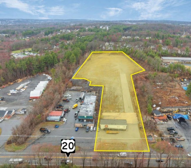
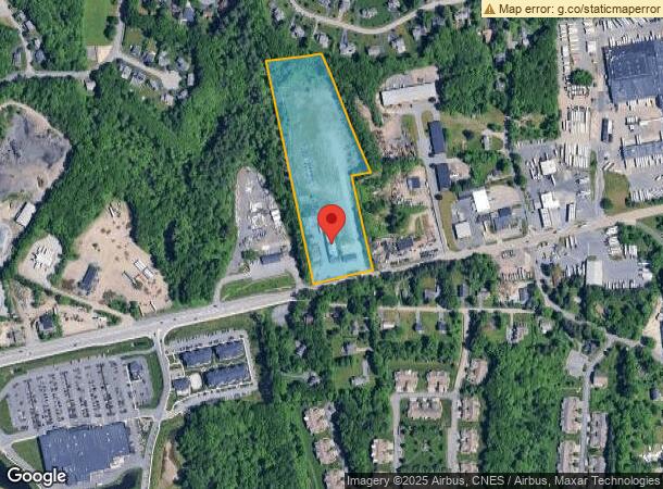
Property Record
249 Hartford Tpke, Shrewsbury, MA 01545

Current Lease Availabilities
NEARBY LISTINGS FOR SALE OR LEASE
Property Detail
249 Hartford Tpke
Commercialnec
Worcester
X
Massachusetts
25027C0826E
12.15 AC
2025
Worcester Metro
2025
Boston
739101
Worcester, MA-CT
7,300 SF
SHRE-000053-000000-002000
DEMOGRAPHICS near 249 Hartford Tpke
1 Mile
3 Mile
5 Mile
2024 Total Population
3,687
57,440
187,840
2029 Population
3,732
57,614
186,720
Pop Growth 2024-2029
+ 1.22%
+ 0.30%
(0.60%)
Average Age
42
41
38
2024 Total Households
1,384
23,353
72,646
HH Growth 2024-2029
+ 1.37%
+ 0.34%
(0.58%)
Median Household Inc
$113,690
$98,683
$72,908
Avg Household Size
2.60
2.40
2.40
2024 Avg HH Vehicles
2.00
2.00
2.00
Median Home Value
$471,428
$396,899
$392,623
Median Year Built
1991
1976
1963
Nearby Places
Map Layers
Map Styles
 Street
 Aerial
- Restaurants
- Banks
- Shops
- Fitness
- Groceries
PUBLIC TRANSPORTATION
COMMUTER RAIL
Grafton (Framingham/Worcester Line - Massachusetts Bay Transportation Authority Commuter Rail (Purple Line))
DRIVE
WALK
Distance
Grafton (Framingham/Worcester Line - Massachusetts Bay Transportation Authority Commuter Rail (Purple Line))
5 min
2.9 mi
Worcester (Framingham/Worcester Line - Massachusetts Bay Transportation Authority Commuter Rail (Purple Line))
DRIVE
WALK
Distance
Worcester (Framingham/Worcester Line - Massachusetts Bay Transportation Authority Commuter Rail (Purple Line))
9 min
5.0 mi
AIRPORT
Worcester Regional
DRIVE
WALK
Distance
Worcester Regional
20 min
10.7 mi
Freight Ports
Port of Boston
DRIVE
WALK
Distance
Port of Boston
57 min
39.3 mi
Nearby Properties
Address
Land Use
TOTAL SIZE
Lot Size
Zoning
Address
Land Use
TOTAL SIZE
Lot Size
Zoning
68.85 AC
OFF-RE
Address
Land Use
TOTAL SIZE
Lot Size
Zoning
26,152 SF
7.97 AC
COM BU
Address
Land Use
TOTAL SIZE
Lot Size
Zoning
46.50 AC
R4
Address
Land Use
TOTAL SIZE
Lot Size
Zoning
22.40 AC
COM BU
Address
Land Use
TOTAL SIZE
Lot Size
Zoning
Address
Land Use
TOTAL SIZE
Lot Size
Zoning
43.07 AC
COM BU
Address
Land Use
TOTAL SIZE
Lot Size
Zoning
23.65 AC
RUR A
Address
Land Use
TOTAL SIZE
Lot Size
Zoning
16.01 AC
COM BU
Address
Land Use
TOTAL SIZE
Lot Size
Zoning
375.66 AC
OLI
Address
Land Use
TOTAL SIZE
Lot Size
Zoning
Address
Land Use
TOTAL SIZE
Lot Size
Zoning
176,316 SF
19.57 AC
RL-7
Address
Land Use
TOTAL SIZE
Lot Size
Zoning
70,514 SF
31.64 AC
RL-7
Address
Land Use
TOTAL SIZE
Lot Size
Zoning
210,168 SF
45.75 AC
RL-7
Address
Land Use
TOTAL SIZE
Lot Size
Zoning
412,272 SF
42.44 AC
OFF-RE
Address
Land Use
TOTAL SIZE
Lot Size
Zoning
142,438 SF
14.26 AC
RES B-
Address
Land Use
TOTAL SIZE
Lot Size
Zoning
21.04 AC
APT 99
Address
Land Use
TOTAL SIZE
Lot Size
Zoning
174,807 SF
32.43 AC
RES B-
Address
Land Use
TOTAL SIZE
Lot Size
Zoning
203,184 SF
0.21 AC
MF-1
Address
Land Use
TOTAL SIZE
Lot Size
Zoning
27.89 AC
RL-7
Address
Land Use
TOTAL SIZE
Lot Size
Zoning
64.46 AC
RS-7
Address
Land Use
TOTAL SIZE
Lot Size
Zoning
9.70 AC
COM BU
Address
Land Use
TOTAL SIZE
Lot Size
Zoning
154,200 SF
4.87 AC
BL-1
Address
Land Use
TOTAL SIZE
Lot Size
Zoning
0.99 AC
MF-1 9
Address
Land Use
TOTAL SIZE
Lot Size
Zoning
134,896 SF
15.10 AC
LIM IN
Address
Land Use
TOTAL SIZE
Lot Size
Zoning
99,908 SF
18.28 AC
RUR AA
Address
Land Use
TOTAL SIZE
Lot Size
Zoning
53.52 AC
RL-7
Address
Land Use
TOTAL SIZE
Lot Size
Zoning
102,181 SF
38.62 AC
RES B-
Address
Land Use
TOTAL SIZE
Lot Size
Zoning
55,178 SF
5 AC
COM BU
Address
Land Use
TOTAL SIZE
Lot Size
Zoning
93,092 SF
162.83 AC
OLI
Address
Land Use
TOTAL SIZE
Lot Size
Zoning
15.26 AC
COM BU
The World's #1 Commercial Real Estate Marketplace
Connect with us
© 2025 CoStar Group
The information above has been obtained from sources believed reliable. While we do not doubt its accuracy we have not verified it and make no guarantee, warranty or representation about it. It is your responsibility to independently confirm its accuracy and completeness. Any projections, opinions, assumptions, or estimates used are for example only and do not represent the current or future performance of the property. The value of this transaction to you depends on tax and other factors which should be evaluated by your tax, financial, and legal advisors. You and your advisors should conduct a careful, independent investigation of the property to determine to your satisfaction the suitability of the property for your needs.