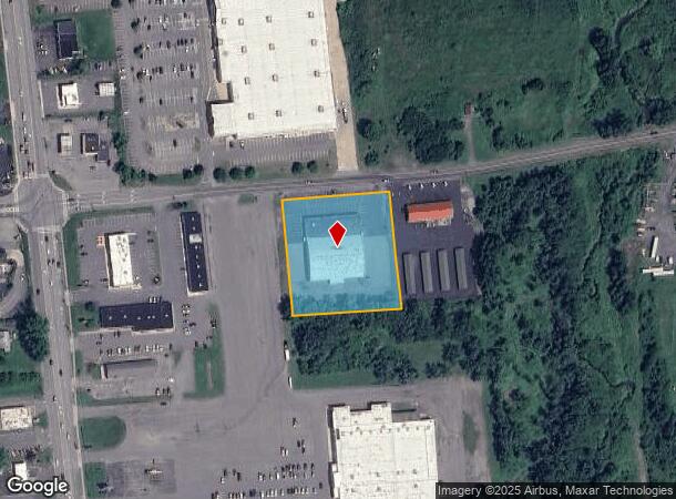
Property Record
249 Wallins Corners Rd, Amsterdam, NY 12010
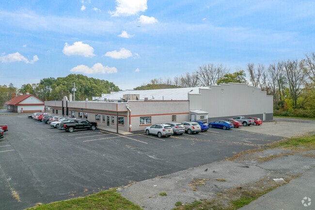
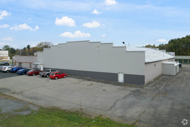
This Property Is For Sale
NEARBY LISTINGS FOR SALE OR LEASE
Property Detail
249 Wallins Corners Rd
272089-024-016-0001-012-002-0000
Montgomery
Bowlingalley
New York
X
12.002
36057C0210E
1.90 AC
2025
Montgomery County
2024
Albany/Schenectady/Troy
072100
Amsterdam, NY
DEMOGRAPHICS near 249 Wallins Corners Rd
1 Mile
3 Mile
5 Mile
2024 Total Population
1,690
23,625
28,229
2029 Population
1,734
23,585
28,137
Pop Growth 2024-2029
+ 2.60%
(0.17%)
(0.33%)
Average Age
49
41
42
2024 Total Households
691
9,858
11,745
HH Growth 2024-2029
+ 2.89%
(0.13%)
(0.30%)
Median Household Inc
$44,078
$47,630
$50,891
Avg Household Size
2.20
2.30
2.30
2024 Avg HH Vehicles
1.00
1.00
2.00
Median Home Value
$150,766
$125,062
$139,024
Median Year Built
1980
1948
1949
Nearby Places
Map Layers
Map Styles
 Street
 Aerial
- Restaurants
- Banks
- Shops
- Fitness
- Groceries
PUBLIC TRANSPORTATION
COMMUTER RAIL
Amsterdam (Toronto - New York - VIA Rail)
DRIVE
WALK
Distance
Amsterdam (Toronto - New York - VIA Rail)
7 min
3.0 mi
Amsterdam Amtrak Station (Empire Service - Amtrak, Maple Leaf - Amtrak)
DRIVE
WALK
Distance
Amsterdam Amtrak Station (Empire Service - Amtrak, Maple Leaf - Amtrak)
7 min
3.0 mi
AIRPORT
Albany International
DRIVE
WALK
Distance
Albany International
51 min
31.7 mi
Freight Ports
Albany, NY Port
DRIVE
WALK
Distance
Albany, NY Port
52 min
38.4 mi
Nearby Properties
Address
Land Use
TOTAL SIZE
Lot Size
Zoning
Address
Land Use
TOTAL SIZE
Lot Size
Zoning
226,614 SF
4.80 AC
05 - COMME
Address
Land Use
TOTAL SIZE
Lot Size
Zoning
197,790 SF
13.90 AC
07 - MIXED
Address
Land Use
TOTAL SIZE
Lot Size
Zoning
27,576 SF
42.80 AC
07 - MIXED
Address
Land Use
TOTAL SIZE
Lot Size
Zoning
26.20 AC
Address
Land Use
TOTAL SIZE
Lot Size
Zoning
66,137 SF
45.40 AC
05 - COMME
Address
Land Use
TOTAL SIZE
Lot Size
Zoning
80,111 SF
4.50 AC
05 - COMME
Address
Land Use
TOTAL SIZE
Lot Size
Zoning
54,169 SF
35 AC
07 - MIXED
Address
Land Use
TOTAL SIZE
Lot Size
Zoning
69,166 SF
22.90 AC
05 - COMME
Address
Land Use
TOTAL SIZE
Lot Size
Zoning
Address
Land Use
TOTAL SIZE
Lot Size
Zoning
86,164 SF
1.20 AC
05 - COMME
Address
Land Use
TOTAL SIZE
Lot Size
Zoning
14,730 SF
8.70 AC
03 - MULTI
Address
Land Use
TOTAL SIZE
Lot Size
Zoning
37,618 SF
1.20 AC
05 - COMME
Address
Land Use
TOTAL SIZE
Lot Size
Zoning
51,667 SF
82 AC
07 - MIXED
Address
Land Use
TOTAL SIZE
Lot Size
Zoning
226,614 SF
1 AC
07 - MIXED
Address
Land Use
TOTAL SIZE
Lot Size
Zoning
Address
Land Use
TOTAL SIZE
Lot Size
Zoning
2,688 SF
49.10 AC
05 - COMME
Address
Land Use
TOTAL SIZE
Lot Size
Zoning
4,160 SF
1.80 AC
07 - MIXED
Address
Land Use
TOTAL SIZE
Lot Size
Zoning
99.30 AC
B1
Address
Land Use
TOTAL SIZE
Lot Size
Zoning
Address
Land Use
TOTAL SIZE
Lot Size
Zoning
59,556 SF
1 AC
07 - MIXED
Address
Land Use
TOTAL SIZE
Lot Size
Zoning
70 AC
02
Address
Land Use
TOTAL SIZE
Lot Size
Zoning
Address
Land Use
TOTAL SIZE
Lot Size
Zoning
200,774 SF
13 AC
05 - COMME
Address
Land Use
TOTAL SIZE
Lot Size
Zoning
70,840 SF
6.45 AC
06 - INDUS
Address
Land Use
TOTAL SIZE
Lot Size
Zoning
16,528 SF
0.85 AC
05 - COMME
Address
Land Use
TOTAL SIZE
Lot Size
Zoning
Address
Land Use
TOTAL SIZE
Lot Size
Zoning
5,800 SF
28 AC
B1
Address
Land Use
TOTAL SIZE
Lot Size
Zoning
13,770 SF
19.90 AC
03 - MULTI
Address
Land Use
TOTAL SIZE
Lot Size
Zoning
720 SF
23.30 AC
03 - MULTI
Address
Land Use
TOTAL SIZE
Lot Size
Zoning
13,770 SF
9.10 AC
03 - MULTI
The World's #1 Commercial Real Estate Marketplace
Connect with us
© 2026 CoStar Group
The information above has been obtained from sources believed reliable. While we do not doubt its accuracy we have not verified it and make no guarantee, warranty or representation about it. It is your responsibility to independently confirm its accuracy and completeness. Any projections, opinions, assumptions, or estimates used are for example only and do not represent the current or future performance of the property. The value of this transaction to you depends on tax and other factors which should be evaluated by your tax, financial, and legal advisors. You and your advisors should conduct a careful, independent investigation of the property to determine to your satisfaction the suitability of the property for your needs.