Property Record
2490 Forrest Ave, Dover, DE 19904


Save to a Folder
{{folder.Name}}
{{folder.ListingIds.length}} Properties
{{folder.ListingIds.length}} Property
Create a New Folder
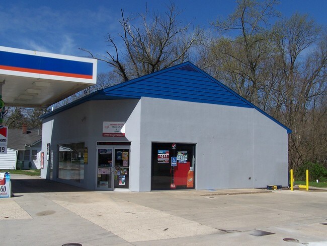
Property Detail
2490 Forrest Ave
2-00-07502-01-1300-000
N SD RT 8 0.9 A 2500 FORREST AVE
Taxexempt
Kent
BG
Delaware
AE The base floodplain where base flood elevations are provided. AE Zones are now used on new format FIRMs instead of A1-A30 Zones.
0.98 AC
0
Kent County
2025
Philadelphia
041804
Dover, DE
1,868 SF
NEARBY LISTINGS FOR SALE OR LEASE
DEMOGRAPHICS near 2490 Forrest Ave
1 mile
3 mile
5 mile
2025 Total Population
2,467
27,051
77,419
2030 Population
2,569
28,233
80,753
Pop Growth 2025-2030
+ 4.13%
+ 4.37%
+ 4.31%
Average Age
39
39
40
2025 Total Households
917
9,680
28,787
HH Growth 2025-2030
+ 4.14%
+ 4.25%
+ 4.25%
Median Household Inc
$75,164
$67,430
$64,649
Avg Household Size
2.70
2.50
2.50
2025 Avg HH Vehicles
2.00
2.00
2.00
Median Home Value
$352,343
$310,425
$292,663
Median Year Built
2000
1988
1986
Nearby Places
Map Layers
Map Styles
 Street
 Aerial
Layers
 Traffic
 Biking
Places
Listings with unknown addresses are not visible on the map
- Restaurants
- Banks
- Shops
- Fitness
- Groceries
SALE & LEASE HISTORY
LISTING DATE
SALE/LEASE

Sep 23, 2016
For Sale
Nearby Properties
Address
Land Use
TOTAL SIZE
Lot Size
Zoning
Address
Land Use
TOTAL SIZE
Lot Size
Zoning
308,750 SF
102.10 AC
R10
Address
Land Use
TOTAL SIZE
Lot Size
Zoning
247,145 SF
43.71 AC
CPO
Address
Land Use
TOTAL SIZE
Lot Size
Zoning
95,706 SF
22.94 AC
R10
Address
Land Use
TOTAL SIZE
Lot Size
Zoning
567,080 SF
30.22 AC
IPM
Address
Land Use
TOTAL SIZE
Lot Size
Zoning
179,601 SF
42.90 AC
IO
Address
Land Use
TOTAL SIZE
Lot Size
Zoning
93,186 SF
89.27 AC
IPM
Address
Land Use
TOTAL SIZE
Lot Size
Zoning
129,471 SF
TND
Address
Land Use
TOTAL SIZE
Lot Size
Zoning
189,000 SF
13.40 AC
RG2
Address
Land Use
TOTAL SIZE
Lot Size
Zoning
60,324 SF
6.70 AC
IO
Address
Land Use
TOTAL SIZE
Lot Size
Zoning
44,560 SF
8.10 AC
IO
Address
Land Use
TOTAL SIZE
Lot Size
Zoning
210,400 SF
30 AC
IPM
Address
Land Use
TOTAL SIZE
Lot Size
Zoning
421,941 SF
23.70 AC
IPM
Address
Land Use
TOTAL SIZE
Lot Size
Zoning
188,100 SF
9.70 AC
RG2
Address
Land Use
TOTAL SIZE
Lot Size
Zoning
69,228 SF
16.90 AC
RG5
Address
Land Use
TOTAL SIZE
Lot Size
Zoning
136,440 SF
6.60 AC
RM1
Address
Land Use
TOTAL SIZE
Lot Size
Zoning
52,250 SF
8.50 AC
RG2
Address
Land Use
TOTAL SIZE
Lot Size
Zoning
82,457 SF
12.40 AC
SC2
Address
Land Use
TOTAL SIZE
Lot Size
Zoning
112,320 SF
15.60 AC
RG2
Address
Land Use
TOTAL SIZE
Lot Size
Zoning
42,940 SF
7.85 AC
RM2
Address
Land Use
TOTAL SIZE
Lot Size
Zoning
68,076 SF
2.63 AC
TND
Address
Land Use
TOTAL SIZE
Lot Size
Zoning
37,779 SF
5.90 AC
RM1
Address
Land Use
TOTAL SIZE
Lot Size
Zoning
62,572 SF
53 AC
RS1
Address
Land Use
TOTAL SIZE
Lot Size
Zoning
11,104 SF
7.56 AC
RG3
Address
Land Use
TOTAL SIZE
Lot Size
Zoning
274,907 SF
14.61 AC
IPM
Address
Land Use
TOTAL SIZE
Lot Size
Zoning
65,264 SF
13.58 AC
IO
Address
Land Use
TOTAL SIZE
Lot Size
Zoning
93,452 SF
5 AC
IPM
Address
Land Use
TOTAL SIZE
Lot Size
Zoning
111,121 SF
8.40 AC
IPM
Address
Land Use
TOTAL SIZE
Lot Size
Zoning
94,050 SF
5.60 AC
RG2
Address
Land Use
TOTAL SIZE
Lot Size
Zoning
41,588 SF
19.64 AC
AP/10
Address
Land Use
TOTAL SIZE
Lot Size
Zoning
87,042 SF
17.30 AC
M
The World's #1 Commercial Real Estate Marketplace
Connect with us
© 2026 CoStar Group
The information above has been obtained from sources believed reliable. While we do not doubt its accuracy we have not verified it and make no guarantee, warranty or representation about it. It is your responsibility to independently confirm its accuracy and completeness. Any projections, opinions, assumptions, or estimates used are for example only and do not represent the current or future performance of the property. The value of this transaction to you depends on tax and other factors which should be evaluated by your tax, financial, and legal advisors. You and your advisors should conduct a careful, independent investigation of the property to determine to your satisfaction the suitability of the property for your needs.