Property Record
2490 S Recker Rd, Gilbert, AZ 85295
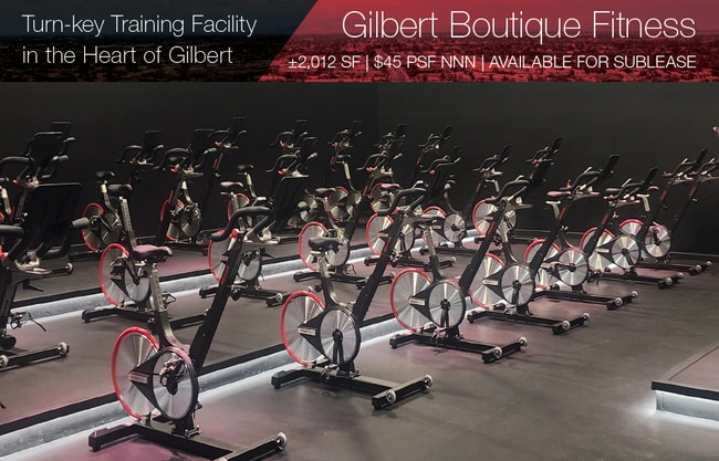

Current Lease Availabilities
Property Detail
2490 S Recker Rd
304-49-989
VERDE AT COOLEY STATION MCR 1501-10
Supermarket
MARICOPA
GVC
Arizona
C and X Area of minimal flood hazard, usually depicted on FIRMs as above the 500-year flood level.
3
2025
0.13 AC
2025
Gateway Airport/Loop 202
815601
Phoenix
4,530 SF
Phoenix-Mesa-Chandler, AZ
NEARBY LISTINGS FOR SALE OR LEASE
-
-
View all Gilbert listings for lease on LoopNet.com
DEMOGRAPHICS near 2490 S Recker Rd
1 mile
3 mile
5 mile
2025 Total Population
17,450
100,540
236,289
2030 Population
18,574
104,959
246,662
Pop Growth 2025-2030
+ 6.44%
+ 4.40%
+ 4.39%
Average Age
34
34
36
2025 Total Households
5,573
32,024
74,591
HH Growth 2025-2030
+ 6.51%
+ 4.52%
+ 4.44%
Median Household Inc
$123,802
$118,770
$128,662
Avg Household Size
3.10
3.10
3.10
2025 Avg HH Vehicles
2.00
2.00
2.00
Median Home Value
$596,713
$600,302
$634,841
Median Year Built
2010
2007
2005
Nearby Places
Map Layers
Map Styles
 Street
 Aerial
Transit
 Traffic
 Biking
Places
Listings with unknown addresses are not visible on the map
- Restaurants
- Banks
- Shops
- Fitness
- Groceries
PUBLIC TRANSPORTATION
AIRPORT
Phoenix-Mesa Gateway
Drive
Walk
Distance
Phoenix-Mesa Gateway
7 min
2.7 mi
Phoenix Sky Harbor International
Drive
Walk
Distance
Phoenix Sky Harbor International
39 min
28.8 mi
Nearby Properties
Address
Land Use
TOTAL SIZE
Lot Size
Zoning
Address
Land Use
TOTAL SIZE
Lot Size
Zoning
Address
Land Use
TOTAL SIZE
Lot Size
Zoning
93,214 SF
10.60 AC
PF
Address
Land Use
TOTAL SIZE
Lot Size
Zoning
1,358,386 SF
611.30 AC
LI
Address
Land Use
TOTAL SIZE
Lot Size
Zoning
862,568 SF
420.15 AC
PS
Address
Land Use
TOTAL SIZE
Lot Size
Zoning
12.66 AC
Address
Land Use
TOTAL SIZE
Lot Size
Zoning
604,432 SF
56.74 AC
PF
Address
Land Use
TOTAL SIZE
Lot Size
Zoning
1,069,038 SF
69.72 AC
Address
Land Use
TOTAL SIZE
Lot Size
Zoning
2.91 AC
Address
Land Use
TOTAL SIZE
Lot Size
Zoning
580,492 SF
41.81 AC
R3
Address
Land Use
TOTAL SIZE
Lot Size
Zoning
298,703 SF
57.08 AC
PF
Address
Land Use
TOTAL SIZE
Lot Size
Zoning
479,727 SF
14.25 AC
MFM
Address
Land Use
TOTAL SIZE
Lot Size
Zoning
615,202 SF
35.88 AC
AG
Address
Land Use
TOTAL SIZE
Lot Size
Zoning
524,905 SF
40.33 AC
Address
Land Use
TOTAL SIZE
Lot Size
Zoning
245,425 SF
205.62 AC
I-1
Address
Land Use
TOTAL SIZE
Lot Size
Zoning
412,581 SF
21.15 AC
MFM
Address
Land Use
TOTAL SIZE
Lot Size
Zoning
225,990 SF
26.23 AC
I-1
Address
Land Use
TOTAL SIZE
Lot Size
Zoning
254,314 SF
23.55 AC
R-43
Address
Land Use
TOTAL SIZE
Lot Size
Zoning
396,754 SF
46.84 AC
PF
Address
Land Use
TOTAL SIZE
Lot Size
Zoning
414,288 SF
28.67 AC
LI
Address
Land Use
TOTAL SIZE
Lot Size
Zoning
348,668 SF
8.97 AC
R3
Address
Land Use
TOTAL SIZE
Lot Size
Zoning
238,386 SF
40.25 AC
BP
Address
Land Use
TOTAL SIZE
Lot Size
Zoning
387,535 SF
15.80 AC
C-G
Address
Land Use
TOTAL SIZE
Lot Size
Zoning
380,383 SF
14.79 AC
C-G
Address
Land Use
TOTAL SIZE
Lot Size
Zoning
323,064 SF
15.90 AC
MFM
Address
Land Use
TOTAL SIZE
Lot Size
Zoning
362,701 SF
9.77 AC
R3
Address
Land Use
TOTAL SIZE
Lot Size
Zoning
583,955 SF
34.92 AC
LI
Address
Land Use
TOTAL SIZE
Lot Size
Zoning
278,044 SF
19.98 AC
PF
Address
Land Use
TOTAL SIZE
Lot Size
Zoning
308,343 SF
13.90 AC
MFM
Address
Land Use
TOTAL SIZE
Lot Size
Zoning
266,467 SF
47.47 AC
PF
Address
Land Use
TOTAL SIZE
Lot Size
Zoning
274,993 SF
16.44 AC
The World's #1 Commercial Real Estate Marketplace
Connect with us
© 2026 CoStar Group
The information above has been obtained from sources believed reliable. While we do not doubt its accuracy we have not verified it and make no guarantee, warranty or representation about it. It is your responsibility to independently confirm its accuracy and completeness. Any projections, opinions, assumptions, or estimates used are for example only and do not represent the current or future performance of the property. The value of this transaction to you depends on tax and other factors which should be evaluated by your tax, financial, and legal advisors. You and your advisors should conduct a careful, independent investigation of the property to determine to your satisfaction the suitability of the property for your needs.