Property Record
24900 Ford Rd, Porter, TX 77365


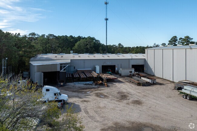
Property Detail
24900 Ford Rd
0660-00-00705
A0660 - WILLIAMS RICHARD, TRACT 4-A, 7-B, ACRES 6.0525
Industrialgeneral
Montgomery
5
Texas
B and X Area of moderate flood hazard, usually the area between the limits of the 100-year and 500-year floods.
6.05 AC
2024
Northeast Hwy 321
2025
Houston
692401
Houston-Pasadena-The Woodlands, TX
109,072 SF
NEARBY LISTINGS FOR SALE OR LEASE
DEMOGRAPHICS near 24900 Ford Rd
1 mile
3 mile
5 mile
2025 Total Population
9,471
60,658
128,546
2030 Population
10,488
66,559
143,703
Pop Growth 2025-2030
+ 10.74%
+ 9.73%
+ 11.79%
Average Age
37
38
39
2025 Total Households
3,228
21,084
46,769
HH Growth 2025-2030
+ 11.34%
+ 10.12%
+ 12.36%
Median Household Inc
$105,673
$101,459
$97,172
Avg Household Size
2.90
2.80
2.70
2025 Avg HH Vehicles
2.00
2.00
2.00
Median Home Value
$278,772
$311,095
$323,144
Median Year Built
1994
1990
1999
Nearby Places
Map Layers
Map Styles
 Street
 Aerial
Transit
 Traffic
 Biking
Places
Listings with unknown addresses are not visible on the map
- Restaurants
- Banks
- Shops
- Fitness
- Groceries
PUBLIC TRANSPORTATION
AIRPORT
George Bush Intcntl/Houston
Drive
Walk
Distance
George Bush Intcntl/Houston
27 min
19.0 mi
Freight Ports
Port of Houston
Drive
Walk
Distance
Port of Houston
48 min
34.3 mi
SALE & LEASE HISTORY
LISTING DATE
SALE/LEASE

Jun 24, 2021
For Sale
Nearby Properties
Address
Land Use
TOTAL SIZE
Lot Size
Zoning
Address
Land Use
TOTAL SIZE
Lot Size
Zoning
130,934 SF
10.71 AC
Address
Land Use
TOTAL SIZE
Lot Size
Zoning
60,584 SF
9.14 AC
Address
Land Use
TOTAL SIZE
Lot Size
Zoning
154,584 SF
46.76 AC
Address
Land Use
TOTAL SIZE
Lot Size
Zoning
256,120 SF
9.81 AC
Address
Land Use
TOTAL SIZE
Lot Size
Zoning
106,147 SF
14.03 AC
Address
Land Use
TOTAL SIZE
Lot Size
Zoning
128,976 SF
16.99 AC
Address
Land Use
TOTAL SIZE
Lot Size
Zoning
215,554 SF
20.89 AC
5
Address
Land Use
TOTAL SIZE
Lot Size
Zoning
190,424 SF
23 AC
Address
Land Use
TOTAL SIZE
Lot Size
Zoning
126,879 SF
12.13 AC
Address
Land Use
TOTAL SIZE
Lot Size
Zoning
139,496 SF
7.43 AC
Address
Land Use
TOTAL SIZE
Lot Size
Zoning
224,810 SF
21.64 AC
5
Address
Land Use
TOTAL SIZE
Lot Size
Zoning
126,662 SF
6.08 AC
Address
Land Use
TOTAL SIZE
Lot Size
Zoning
43,660 SF
3.10 AC
Address
Land Use
TOTAL SIZE
Lot Size
Zoning
128,079 SF
5.30 AC
Address
Land Use
TOTAL SIZE
Lot Size
Zoning
13,238 SF
35 AC
Address
Land Use
TOTAL SIZE
Lot Size
Zoning
45,077 SF
5.17 AC
Address
Land Use
TOTAL SIZE
Lot Size
Zoning
113,545 SF
10.70 AC
Address
Land Use
TOTAL SIZE
Lot Size
Zoning
20,440 SF
2.01 AC
Address
Land Use
TOTAL SIZE
Lot Size
Zoning
23.03 AC
5
Address
Land Use
TOTAL SIZE
Lot Size
Zoning
67,298 SF
7.06 AC
Address
Land Use
TOTAL SIZE
Lot Size
Zoning
117,146 SF
8.25 AC
5
Address
Land Use
TOTAL SIZE
Lot Size
Zoning
55,023 SF
5.58 AC
Address
Land Use
TOTAL SIZE
Lot Size
Zoning
90,142 SF
10.80 AC
5
Address
Land Use
TOTAL SIZE
Lot Size
Zoning
72,806 SF
2.15 AC
Address
Land Use
TOTAL SIZE
Lot Size
Zoning
58,907 SF
3.57 AC
Address
Land Use
TOTAL SIZE
Lot Size
Zoning
27,456 SF
2.50 AC
Address
Land Use
TOTAL SIZE
Lot Size
Zoning
28,000 SF
8.38 AC
Address
Land Use
TOTAL SIZE
Lot Size
Zoning
78,027 SF
13.40 AC
5
Address
Land Use
TOTAL SIZE
Lot Size
Zoning
103,709 SF
17.58 AC
5
The World's #1 Commercial Real Estate Marketplace
Connect with us
© 2026 CoStar Group
The information above has been obtained from sources believed reliable. While we do not doubt its accuracy we have not verified it and make no guarantee, warranty or representation about it. It is your responsibility to independently confirm its accuracy and completeness. Any projections, opinions, assumptions, or estimates used are for example only and do not represent the current or future performance of the property. The value of this transaction to you depends on tax and other factors which should be evaluated by your tax, financial, and legal advisors. You and your advisors should conduct a careful, independent investigation of the property to determine to your satisfaction the suitability of the property for your needs.