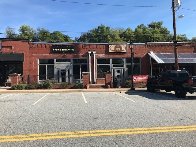
Property Record
2493 2Nd Ave, Dacula, GA 30019

Property Detail
2493 2Nd Ave
5-302A-014
SECOND AVE 10 BL B BLDG DAC
Storebuilding
Gwinnett
C2
Georgia
B and X Area of moderate flood hazard, usually the area between the limits of the 100-year and 500-year floods.
10
0
0.05 AC
2025
Suwanee/Buford
050627
Atlanta
2,000 SF
Atlanta-Sandy Springs-Roswell, GA
NEARBY LISTINGS FOR SALE OR LEASE
-
-
View all Dacula listings for sale on LoopNet.com
DEMOGRAPHICS near 2493 2Nd Ave
1 mile
3 mile
5 mile
2024 Total Population
4,270
38,977
118,441
2029 Population
4,541
41,373
125,380
Pop Growth 2024-2029
+ 6.35%
+ 6.15%
+ 5.86%
Average Age
37
36
37
2024 Total Households
1,361
11,692
35,535
HH Growth 2024-2029
+ 6.54%
+ 6.21%
+ 6.12%
Median Household Inc
$76,822
$98,630
$91,080
Avg Household Size
3.10
3.30
3.20
2024 Avg HH Vehicles
2.00
2.00
2.00
Median Home Value
$241,063
$289,272
$303,278
Median Year Built
1993
2004
2002
Nearby Places
Map Layers
Map Styles
 Street
 Aerial
Transit
 Traffic
 Biking
Places
Listings with unknown addresses are not visible on the map
- Restaurants
- Banks
- Shops
- Fitness
- Groceries
PUBLIC TRANSPORTATION
AIRPORT
Hartsfield - Jackson Atlanta International
Drive
Walk
Distance
Hartsfield - Jackson Atlanta International
62 min
46.3 mi
SALE & LEASE HISTORY
LISTING DATE
SALE/LEASE

Oct 12, 2018
For Sale
Oct 09, 2023
For Sale
Mar 26, 2019
For Sale
Nearby Properties
Address
Land Use
TOTAL SIZE
Lot Size
Zoning
Address
Land Use
TOTAL SIZE
Lot Size
Zoning
2,260,742 SF
285.40 AC
M1
Address
Land Use
TOTAL SIZE
Lot Size
Zoning
240,800 SF
28.74 AC
M1
Address
Land Use
TOTAL SIZE
Lot Size
Zoning
250,960 SF
17.55 AC
OI
Address
Land Use
TOTAL SIZE
Lot Size
Zoning
101,343 SF
44.33 AC
R1400
Address
Land Use
TOTAL SIZE
Lot Size
Zoning
204,895 SF
26.89 AC
R1200
Address
Land Use
TOTAL SIZE
Lot Size
Zoning
149,440 SF
28.41 AC
M1
Address
Land Use
TOTAL SIZE
Lot Size
Zoning
178,635 SF
28.77 AC
R1200
Address
Land Use
TOTAL SIZE
Lot Size
Zoning
140,809 SF
8.97 AC
RM13
Address
Land Use
TOTAL SIZE
Lot Size
Zoning
310,027 SF
18.54 AC
M1
Address
Land Use
TOTAL SIZE
Lot Size
Zoning
164,850 SF
14.45 AC
M1
Address
Land Use
TOTAL SIZE
Lot Size
Zoning
327,884 SF
19 AC
M1
Address
Land Use
TOTAL SIZE
Lot Size
Zoning
179,065 SF
24 AC
M1
Address
Land Use
TOTAL SIZE
Lot Size
Zoning
160,446 SF
12 AC
GOV
Address
Land Use
TOTAL SIZE
Lot Size
Zoning
61,686 SF
10 AC
R1400
Address
Land Use
TOTAL SIZE
Lot Size
Zoning
102,618 SF
18 AC
R1200
Address
Land Use
TOTAL SIZE
Lot Size
Zoning
4,588 SF
109.24 AC
RZT
Address
Land Use
TOTAL SIZE
Lot Size
Zoning
143,845 SF
31.36 AC
RA200
Address
Land Use
TOTAL SIZE
Lot Size
Zoning
99,516 SF
10.83 AC
C3
Address
Land Use
TOTAL SIZE
Lot Size
Zoning
73.79 AC
RZT
Address
Land Use
TOTAL SIZE
Lot Size
Zoning
110,540 SF
22.94 AC
M1
Address
Land Use
TOTAL SIZE
Lot Size
Zoning
47,141 SF
8.29 AC
AG
Address
Land Use
TOTAL SIZE
Lot Size
Zoning
70,345 SF
10.51 AC
PMUD
Address
Land Use
TOTAL SIZE
Lot Size
Zoning
104.38 AC
MUR
Address
Land Use
TOTAL SIZE
Lot Size
Zoning
86,111 SF
16.03 AC
C2
Address
Land Use
TOTAL SIZE
Lot Size
Zoning
164,442 SF
18 AC
C2
Address
Land Use
TOTAL SIZE
Lot Size
Zoning
69,901 SF
10.01 AC
C2
Address
Land Use
TOTAL SIZE
Lot Size
Zoning
150,600 SF
11.82 AC
M1
Address
Land Use
TOTAL SIZE
Lot Size
Zoning
11,324 SF
25 AC
R1200
Address
Land Use
TOTAL SIZE
Lot Size
Zoning
149,540 SF
16.37 AC
M1
Address
Land Use
TOTAL SIZE
Lot Size
Zoning
70.45 AC
R1400
The World's #1 Commercial Real Estate Marketplace
Connect with us
© 2026 CoStar Group
The information above has been obtained from sources believed reliable. While we do not doubt its accuracy we have not verified it and make no guarantee, warranty or representation about it. It is your responsibility to independently confirm its accuracy and completeness. Any projections, opinions, assumptions, or estimates used are for example only and do not represent the current or future performance of the property. The value of this transaction to you depends on tax and other factors which should be evaluated by your tax, financial, and legal advisors. You and your advisors should conduct a careful, independent investigation of the property to determine to your satisfaction the suitability of the property for your needs.