Property Record
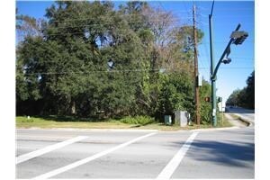
2499 Nw 97Th Dr, Gainesville, FL 32606

Property Detail
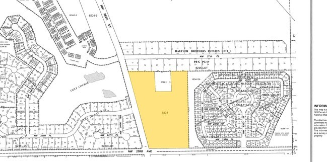
2499 Nw 97Th Dr
06234-000-000
S1/2 OF SE1/4 LESS R/W AND LESS N 335 FT OF W 265 FT OF E 2233 FT M/L PER OR 2008 /1160) LESS COM SE COR SEC N 50 FT POB N 1271.12 FT W 1713.16 FT S 1271.68 FT E 1713.16 FT POB PER OR 2132/2177-2179) (LESS COM NW COR OF BROOKFIELD CLUSTER PH III PB 2
Multifamilydwelling
ALACHUA
R-1A
Florida
A Areas with a 1% annual chance of flooding and a 26% chance of flooding over the life of a 30-year mortgage.
12
2025
13.66 AC
2025
Northwest Gainesville
002204
Other Market Areas
297,651 SF
Gainesville, FL
NEARBY LISTINGS FOR SALE OR LEASE
DEMOGRAPHICS near 2499 Nw 97Th Dr
1 mile
3 mile
5 mile
2025 Total Population
6,101
38,451
99,089
2030 Population
6,358
40,051
103,034
Pop Growth 2025-2030
+ 4.21%
+ 4.16%
+ 3.98%
Average Age
39
39
39
2025 Total Households
2,449
15,948
41,502
HH Growth 2025-2030
+ 4.86%
+ 4.66%
+ 4.53%
Median Household Inc
$106,033
$85,686
$81,113
Avg Household Size
2.50
2.40
2.30
2025 Avg HH Vehicles
2.00
2.00
2.00
Median Home Value
$410,052
$418,270
$376,588
Median Year Built
1995
1992
1990
Nearby Places
Map Layers
Map Styles
 Street
 Aerial
Layers
 Traffic
 Biking
Places
Listings with unknown addresses are not visible on the map
- Restaurants
- Banks
- Shops
- Fitness
- Groceries
PUBLIC TRANSPORTATION
AIRPORT
Gainesville Regional
Drive
Walk
Distance
Gainesville Regional
25 min
12.3 mi
Freight Ports
Jacksonville Port
Drive
Walk
Distance
Jacksonville Port
111 min
82.1 mi
Nearby Properties
Address
Land Use
TOTAL SIZE
Lot Size
Zoning
Address
Land Use
TOTAL SIZE
Lot Size
Zoning
317,057 SF
128.93 AC
RP
Address
Land Use
TOTAL SIZE
Lot Size
Zoning
1,005,666 SF
11.60 AC
MD
Address
Land Use
TOTAL SIZE
Lot Size
Zoning
141,984 SF
20 AC
HM
Address
Land Use
TOTAL SIZE
Lot Size
Zoning
790,684 SF
57.09 AC
U8
Address
Land Use
TOTAL SIZE
Lot Size
Zoning
392,717 SF
47.62 AC
R-2
Address
Land Use
TOTAL SIZE
Lot Size
Zoning
318,578 SF
21.24 AC
RMF7
Address
Land Use
TOTAL SIZE
Lot Size
Zoning
335,387 SF
26.55 AC
R-1A
Address
Land Use
TOTAL SIZE
Lot Size
Zoning
153,592 SF
24.98 AC
R-2
Address
Land Use
TOTAL SIZE
Lot Size
Zoning
626,679 SF
41.04 AC
A
Address
Land Use
TOTAL SIZE
Lot Size
Zoning
317,776 SF
14.67 AC
PD
Address
Land Use
TOTAL SIZE
Lot Size
Zoning
349,789 SF
28.08 AC
PD
Address
Land Use
TOTAL SIZE
Lot Size
Zoning
794,044 SF
80.54 AC
PD
Address
Land Use
TOTAL SIZE
Lot Size
Zoning
206,071 SF
43.34 AC
A
Address
Land Use
TOTAL SIZE
Lot Size
Zoning
326,376 SF
39.94 AC
R-2
Address
Land Use
TOTAL SIZE
Lot Size
Zoning
296,660 SF
21.78 AC
R-3
Address
Land Use
TOTAL SIZE
Lot Size
Zoning
279,819 SF
18.03 AC
R-1B
Address
Land Use
TOTAL SIZE
Lot Size
Zoning
242,053 SF
26.93 AC
R-2A
Address
Land Use
TOTAL SIZE
Lot Size
Zoning
135,060 SF
2.48 AC
PD
Address
Land Use
TOTAL SIZE
Lot Size
Zoning
168,261 SF
23.50 AC
BH
Address
Land Use
TOTAL SIZE
Lot Size
Zoning
80,786 SF
15 AC
ED
Address
Land Use
TOTAL SIZE
Lot Size
Zoning
155,747 SF
14.77 AC
RMF7
Address
Land Use
TOTAL SIZE
Lot Size
Zoning
314,049 SF
19.80 AC
PD
Address
Land Use
TOTAL SIZE
Lot Size
Zoning
195,165 SF
8.76 AC
MU1
Address
Land Use
TOTAL SIZE
Lot Size
Zoning
223,337 SF
16.10 AC
R-3
Address
Land Use
TOTAL SIZE
Lot Size
Zoning
216,468 SF
17.27 AC
R-2A
Address
Land Use
TOTAL SIZE
Lot Size
Zoning
61,836 SF
10.97 AC
BH
Address
Land Use
TOTAL SIZE
Lot Size
Zoning
135,610 SF
11.01 AC
R-2A
Address
Land Use
TOTAL SIZE
Lot Size
Zoning
137,483 SF
8.24 AC
U8
Address
Land Use
TOTAL SIZE
Lot Size
Zoning
109,463 SF
4.92 AC
BH
The World's #1 Commercial Real Estate Marketplace
Connect with us
© 2026 CoStar Group
The information above has been obtained from sources believed reliable. While we do not doubt its accuracy we have not verified it and make no guarantee, warranty or representation about it. It is your responsibility to independently confirm its accuracy and completeness. Any projections, opinions, assumptions, or estimates used are for example only and do not represent the current or future performance of the property. The value of this transaction to you depends on tax and other factors which should be evaluated by your tax, financial, and legal advisors. You and your advisors should conduct a careful, independent investigation of the property to determine to your satisfaction the suitability of the property for your needs.