Property Record
2499 Sw 60Th Ave, Ocala, FL 34474
NEARBY LISTINGS FOR SALE OR LEASE
Property Detail
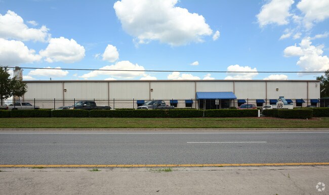
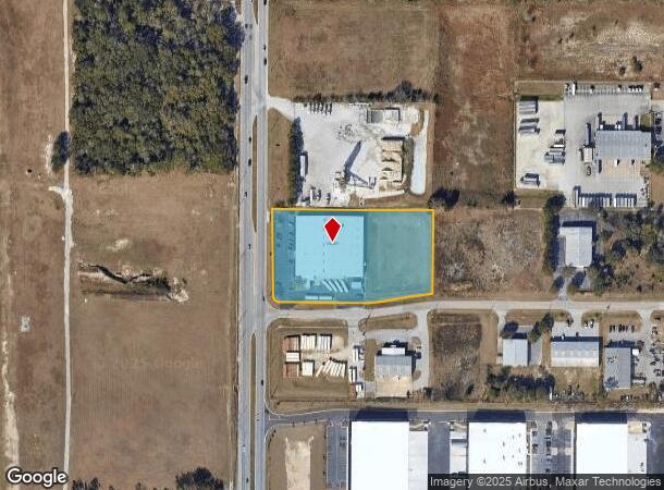
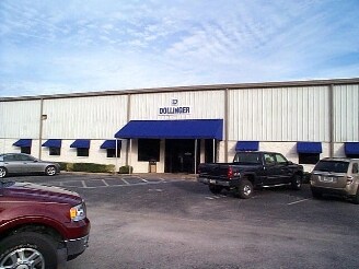
2499 Sw 60Th Ave
Ocala, FL
Runway Industrial Plaza
23819-001-01
SEC 28 TWP 15 RGE 21 PLAT BOOK 002 PAGE 059 RUNWAY INDUSTRIAL PLAZA BLK A LOT 1
Lightindustrial
Marion
X
Florida
12083C0512E
1
2025
2.02 AC
2025
Greater Ocala
002507
Ocala
41,523 SF
DEMOGRAPHICS near 2499 Sw 60Th Ave
1 Mile
3 Mile
5 Mile
2024 Total Population
1,962
23,718
52,901
2029 Population
2,169
26,766
59,995
Pop Growth 2024-2029
+ 10.55%
+ 12.85%
+ 13.41%
Average Age
39
41
45
2024 Total Households
928
9,186
22,224
HH Growth 2024-2029
+ 10.45%
+ 13.06%
+ 13.49%
Median Household Inc
$52,158
$55,838
$54,050
Avg Household Size
2.10
2.30
2.20
2024 Avg HH Vehicles
1.00
1.00
1.00
Median Home Value
$71,487
$205,352
$228,289
Median Year Built
1986
1992
1995
Nearby Places
Map Layers
Map Styles
 Street
 Aerial
- Restaurants
- Banks
- Shops
- Fitness
- Groceries
Nearby Properties
Address
Land Use
TOTAL SIZE
Lot Size
Zoning
Address
Land Use
TOTAL SIZE
Lot Size
Zoning
2,015,469 SF
169.30 AC
M1
Address
Land Use
TOTAL SIZE
Lot Size
Zoning
493,261 SF
126.01 AC
R3
Address
Land Use
TOTAL SIZE
Lot Size
Zoning
156,201 SF
36.77 AC
INST
Address
Land Use
TOTAL SIZE
Lot Size
Zoning
446,764 SF
138.06 AC
GU
Address
Land Use
TOTAL SIZE
Lot Size
Zoning
283,913 SF
24.22 AC
B2
Address
Land Use
TOTAL SIZE
Lot Size
Zoning
120,296 SF
35.67 AC
PD
Address
Land Use
TOTAL SIZE
Lot Size
Zoning
192,480 SF
23.19 AC
R3
Address
Land Use
TOTAL SIZE
Lot Size
Zoning
164,363 SF
16.51 AC
R3
Address
Land Use
TOTAL SIZE
Lot Size
Zoning
324,262 SF
40.79 AC
SC
Address
Land Use
TOTAL SIZE
Lot Size
Zoning
422,264 SF
40.87 AC
SC
Address
Land Use
TOTAL SIZE
Lot Size
Zoning
189,662 SF
25.54 AC
B2
Address
Land Use
TOTAL SIZE
Lot Size
Zoning
154,675 SF
23.62 AC
PD09
Address
Land Use
TOTAL SIZE
Lot Size
Zoning
87,034 SF
14.45 AC
R3
Address
Land Use
TOTAL SIZE
Lot Size
Zoning
322,193 SF
70.13 AC
INST
Address
Land Use
TOTAL SIZE
Lot Size
Zoning
154,870 SF
23.50 AC
PD
Address
Land Use
TOTAL SIZE
Lot Size
Zoning
152,355 SF
973.50 AC
GU
Address
Land Use
TOTAL SIZE
Lot Size
Zoning
111,644 SF
19 AC
PD09
Address
Land Use
TOTAL SIZE
Lot Size
Zoning
403,023 SF
47.47 AC
M1
Address
Land Use
TOTAL SIZE
Lot Size
Zoning
222,210 SF
22.14 AC
SC
Address
Land Use
TOTAL SIZE
Lot Size
Zoning
65,570 SF
18.96 AC
PD
Address
Land Use
TOTAL SIZE
Lot Size
Zoning
110,226 SF
19.56 AC
PD09
Address
Land Use
TOTAL SIZE
Lot Size
Zoning
422,369 SF
51.11 AC
M2
Address
Land Use
TOTAL SIZE
Lot Size
Zoning
60,816 SF
13.67 AC
PD
Address
Land Use
TOTAL SIZE
Lot Size
Zoning
194,275 SF
13.43 AC
M1
Address
Land Use
TOTAL SIZE
Lot Size
Zoning
186,474 SF
18.52 AC
SC
Address
Land Use
TOTAL SIZE
Lot Size
Zoning
43,905 SF
6.29 AC
B2
Address
Land Use
TOTAL SIZE
Lot Size
Zoning
59,706 SF
10.01 AC
PD
Address
Land Use
TOTAL SIZE
Lot Size
Zoning
392,617 SF
23.83 AC
M1
Address
Land Use
TOTAL SIZE
Lot Size
Zoning
113,501 SF
68.56 AC
INST
Address
Land Use
TOTAL SIZE
Lot Size
Zoning
364,404 SF
31.83 AC
M1
The World's #1 Commercial Real Estate Marketplace
Connect with us
© 2026 CoStar Group
The information above has been obtained from sources believed reliable. While we do not doubt its accuracy we have not verified it and make no guarantee, warranty or representation about it. It is your responsibility to independently confirm its accuracy and completeness. Any projections, opinions, assumptions, or estimates used are for example only and do not represent the current or future performance of the property. The value of this transaction to you depends on tax and other factors which should be evaluated by your tax, financial, and legal advisors. You and your advisors should conduct a careful, independent investigation of the property to determine to your satisfaction the suitability of the property for your needs.