Property Record
25 Bellows St, Warwick, RI 02888
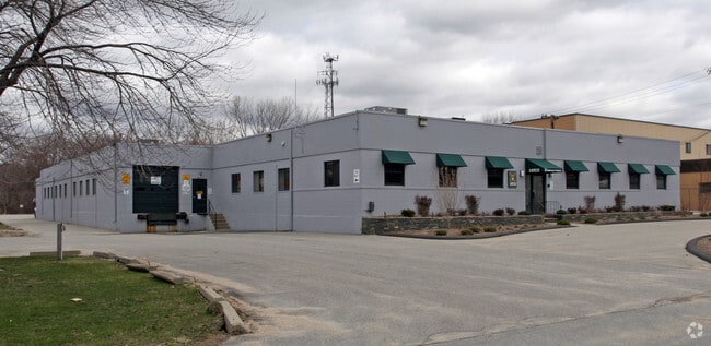

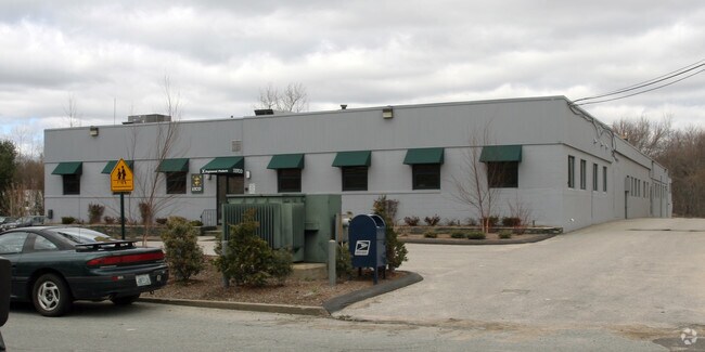
Property Detail
25 Bellows St
Industrialgeneral
Kent
LI
Rhode Island
AE The base floodplain where base flood elevations are provided. AE Zones are now used on new format FIRMs instead of A1-A30 Zones.
1.61 AC
2025
Warwick
2025
Providence
021002
Providence-Warwick, RI-MA
26,092 SF
WARW-000291-000048-000000
NEARBY LISTINGS FOR SALE OR LEASE
DEMOGRAPHICS near 25 Bellows St
1 mile
3 mile
5 mile
2025 Total Population
13,119
106,122
310,920
2030 Population
13,376
108,309
318,129
Pop Growth 2025-2030
+ 1.96%
+ 2.06%
+ 2.32%
Average Age
43
41
40
2025 Total Households
5,736
42,624
123,719
HH Growth 2025-2030
+ 1.88%
+ 2.13%
+ 2.54%
Median Household Inc
$90,744
$77,410
$75,383
Avg Household Size
2.20
2.40
2.30
2025 Avg HH Vehicles
2.00
2.00
2.00
Median Home Value
$386,062
$354,881
$369,053
Median Year Built
1947
1950
1952
Nearby Places
Map Layers
Map Styles
 Street
 Aerial
Transit
 Traffic
 Biking
Places
Listings with unknown addresses are not visible on the map
- Restaurants
- Banks
- Shops
- Fitness
- Groceries
PUBLIC TRANSPORTATION
COMMUTER RAIL
Drive
Walk
Distance
9 min
4.1 mi
Providence (Providence/Stoughton Line - Massachusetts Bay Transportation Authority Commuter Rail (Purple Line))
Drive
Walk
Distance
Providence (Providence/Stoughton Line - Massachusetts Bay Transportation Authority Commuter Rail (Purple Line))
12 min
5.6 mi
AIRPORT
Rhode Island Tf Green International
Drive
Walk
Distance
Rhode Island Tf Green International
10 min
3.9 mi
Worcester Regional
Drive
Walk
Distance
Worcester Regional
70 min
49.3 mi
Freight Ports
Port of Davisville, RI
Drive
Walk
Distance
Port of Davisville, RI
32 min
18.1 mi
Nearby Properties
Address
Land Use
TOTAL SIZE
Lot Size
Zoning
Address
Land Use
TOTAL SIZE
Lot Size
Zoning
45,000 SF
22.22 AC
M2
Address
Land Use
TOTAL SIZE
Lot Size
Zoning
Address
Land Use
TOTAL SIZE
Lot Size
Zoning
7.53 AC
I-2
Address
Land Use
TOTAL SIZE
Lot Size
Zoning
6.80 AC
R-3
Address
Land Use
TOTAL SIZE
Lot Size
Zoning
15.20 AC
R5
Address
Land Use
TOTAL SIZE
Lot Size
Zoning
99,500 SF
4.94 AC
PS
Address
Land Use
TOTAL SIZE
Lot Size
Zoning
104,999 SF
8.86 AC
C-3
Address
Land Use
TOTAL SIZE
Lot Size
Zoning
491,496 SF
46.72 AC
LI
Address
Land Use
TOTAL SIZE
Lot Size
Zoning
247,671 SF
10.78 AC
A7
Address
Land Use
TOTAL SIZE
Lot Size
Zoning
16.48 AC
W-3
Address
Land Use
TOTAL SIZE
Lot Size
Zoning
10.90 AC
EI
Address
Land Use
TOTAL SIZE
Lot Size
Zoning
4.91 AC
I-2
Address
Land Use
TOTAL SIZE
Lot Size
Zoning
Address
Land Use
TOTAL SIZE
Lot Size
Zoning
Address
Land Use
TOTAL SIZE
Lot Size
Zoning
2,308 SF
12.82 AC
B2
Address
Land Use
TOTAL SIZE
Lot Size
Zoning
77,631 SF
2.97 AC
I-2
Address
Land Use
TOTAL SIZE
Lot Size
Zoning
81,129 SF
5.75 AC
A8
Address
Land Use
TOTAL SIZE
Lot Size
Zoning
110,031 SF
5.07 AC
EH
Address
Land Use
TOTAL SIZE
Lot Size
Zoning
9.35 AC
C1
Address
Land Use
TOTAL SIZE
Lot Size
Zoning
6.30 AC
PS
Address
Land Use
TOTAL SIZE
Lot Size
Zoning
184,286 SF
2.91 AC
C1
Address
Land Use
TOTAL SIZE
Lot Size
Zoning
225,458 SF
24.95 AC
I1
Address
Land Use
TOTAL SIZE
Lot Size
Zoning
123,706 SF
1.85 AC
M2
Address
Land Use
TOTAL SIZE
Lot Size
Zoning
115,040 SF
3.46 AC
PS
Address
Land Use
TOTAL SIZE
Lot Size
Zoning
115,264 SF
11.98 AC
A7
Address
Land Use
TOTAL SIZE
Lot Size
Zoning
155,770 SF
1.37 AC
M-1
Address
Land Use
TOTAL SIZE
Lot Size
Zoning
201,941 SF
5.30 AC
I-2
Address
Land Use
TOTAL SIZE
Lot Size
Zoning
15.71 AC
M-1
Address
Land Use
TOTAL SIZE
Lot Size
Zoning
294,355 SF
19.51 AC
Address
Land Use
TOTAL SIZE
Lot Size
Zoning
145,611 SF
9.33 AC
A6
The World's #1 Commercial Real Estate Marketplace
Connect with us
© 2026 CoStar Group
The information above has been obtained from sources believed reliable. While we do not doubt its accuracy we have not verified it and make no guarantee, warranty or representation about it. It is your responsibility to independently confirm its accuracy and completeness. Any projections, opinions, assumptions, or estimates used are for example only and do not represent the current or future performance of the property. The value of this transaction to you depends on tax and other factors which should be evaluated by your tax, financial, and legal advisors. You and your advisors should conduct a careful, independent investigation of the property to determine to your satisfaction the suitability of the property for your needs.