Property Record
25 Boulder Way, Biddeford, ME 04005
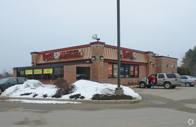

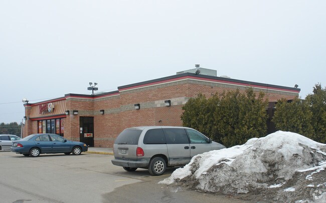
Property Detail
25 Boulder Way
BIDD-000002-000000-000058-000001
YORK
Restaurantbuilding
Maine
I3
58-1
A Areas with a 1% annual chance of flooding and a 26% chance of flooding over the life of a 30-year mortgage.
6.38 AC
2025
York County
2025
Portland/South Portland
025203
Portland-South Portland, ME
3,320 SF
NEARBY LISTINGS FOR SALE OR LEASE
DEMOGRAPHICS near 25 Boulder Way
1 mile
3 mile
5 mile
2025 Total Population
471
21,941
40,868
2030 Population
474
22,182
41,549
Pop Growth 2025-2030
+ 0.64%
+ 1.10%
+ 1.67%
Average Age
44
41
43
2025 Total Households
187
9,717
17,452
HH Growth 2025-2030
+ 0.53%
+ 1.06%
+ 1.58%
Median Household Inc
$98,499
$69,138
$76,940
Avg Household Size
2.50
2.20
2.20
2025 Avg HH Vehicles
2.00
2.00
2.00
Median Home Value
$413,158
$382,769
$405,182
Median Year Built
1978
1960
1974
Nearby Places
Map Layers
Map Styles
 Street
 Aerial
Layers
 Traffic
 Biking
Places
Listings with unknown addresses are not visible on the map
- Restaurants
- Banks
- Shops
- Fitness
- Groceries
PUBLIC TRANSPORTATION
COMMUTER RAIL
Drive
Walk
Distance
6 min
3.2 mi
AIRPORT
Portland International Jetport
Drive
Walk
Distance
Portland International Jetport
23 min
16.3 mi
Portsmouth International at Pease
Drive
Walk
Distance
Portsmouth International at Pease
46 min
35.5 mi
Nearby Properties
Address
Land Use
TOTAL SIZE
Lot Size
Zoning
Address
Land Use
TOTAL SIZE
Lot Size
Zoning
25.99 AC
M
Address
Land Use
TOTAL SIZE
Lot Size
Zoning
233,280 SF
8.40 AC
MSRD3
Address
Land Use
TOTAL SIZE
Lot Size
Zoning
230,822 SF
3.50 AC
MSRD3
Address
Land Use
TOTAL SIZE
Lot Size
Zoning
8.47 AC
R1B
Address
Land Use
TOTAL SIZE
Lot Size
Zoning
69,442 SF
1.12 AC
B2
Address
Land Use
TOTAL SIZE
Lot Size
Zoning
Address
Land Use
TOTAL SIZE
Lot Size
Zoning
118,458 SF
18.93 AC
B2
Address
Land Use
TOTAL SIZE
Lot Size
Zoning
136,033 SF
15.71 AC
B2
Address
Land Use
TOTAL SIZE
Lot Size
Zoning
262,580 SF
40.10 AC
I1
Address
Land Use
TOTAL SIZE
Lot Size
Zoning
197,008 SF
44.47 AC
B1
Address
Land Use
TOTAL SIZE
Lot Size
Zoning
224,607 SF
5.07 AC
B-4
Address
Land Use
TOTAL SIZE
Lot Size
Zoning
91,642 SF
21.43 AC
R1A
Address
Land Use
TOTAL SIZE
Lot Size
Zoning
136,348 SF
1.57 AC
MSRD3
Address
Land Use
TOTAL SIZE
Lot Size
Zoning
17.50 AC
B2
Address
Land Use
TOTAL SIZE
Lot Size
Zoning
119,500 SF
28.24 AC
B2
Address
Land Use
TOTAL SIZE
Lot Size
Zoning
35,008 SF
10.19 AC
RF SR1
Address
Land Use
TOTAL SIZE
Lot Size
Zoning
72,508 SF
2.57 AC
MSRD3
Address
Land Use
TOTAL SIZE
Lot Size
Zoning
15.36 AC
I1
Address
Land Use
TOTAL SIZE
Lot Size
Zoning
64,788 SF
25.50 AC
R1A
Address
Land Use
TOTAL SIZE
Lot Size
Zoning
77,406 SF
16 AC
R1A
Address
Land Use
TOTAL SIZE
Lot Size
Zoning
75,382 SF
0.85 AC
MSRD3
Address
Land Use
TOTAL SIZE
Lot Size
Zoning
9.62 AC
B2
Address
Land Use
TOTAL SIZE
Lot Size
Zoning
39,580 SF
9.59 AC
R-2
Address
Land Use
TOTAL SIZE
Lot Size
Zoning
139,607 SF
13.20 AC
I1
Address
Land Use
TOTAL SIZE
Lot Size
Zoning
41,436 SF
6.61 AC
I3
Address
Land Use
TOTAL SIZE
Lot Size
Zoning
60,268 SF
1.16 AC
MSRD3
Address
Land Use
TOTAL SIZE
Lot Size
Zoning
51,376 SF
7.12 AC
I3
Address
Land Use
TOTAL SIZE
Lot Size
Zoning
20.64 AC
B2
Address
Land Use
TOTAL SIZE
Lot Size
Zoning
2.37 AC
W2
Address
Land Use
TOTAL SIZE
Lot Size
Zoning
62,025 SF
6.25 AC
B2
The World's #1 Commercial Real Estate Marketplace
Connect with us
© 2026 CoStar Group
The information above has been obtained from sources believed reliable. While we do not doubt its accuracy we have not verified it and make no guarantee, warranty or representation about it. It is your responsibility to independently confirm its accuracy and completeness. Any projections, opinions, assumptions, or estimates used are for example only and do not represent the current or future performance of the property. The value of this transaction to you depends on tax and other factors which should be evaluated by your tax, financial, and legal advisors. You and your advisors should conduct a careful, independent investigation of the property to determine to your satisfaction the suitability of the property for your needs.