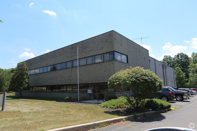
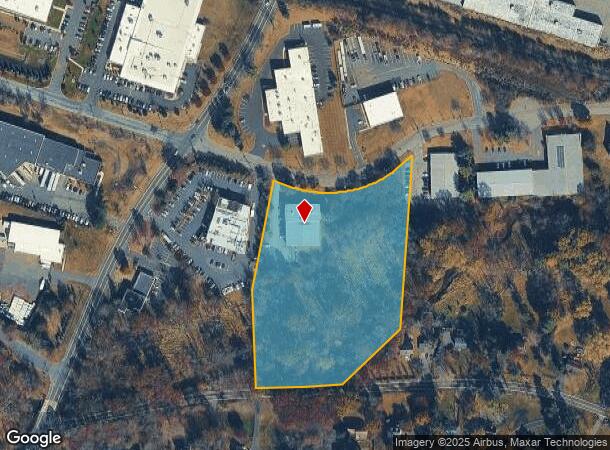
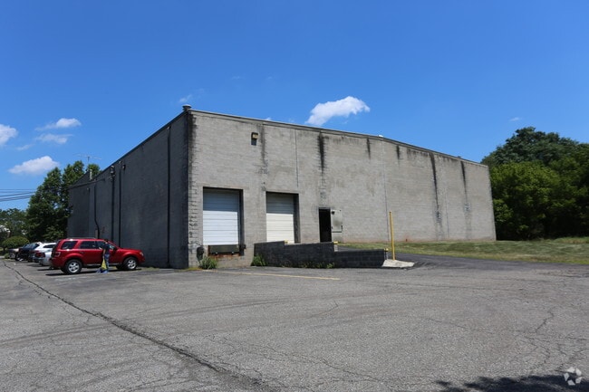
Property Record
25 Chambers Brook Rd, Branchburg, NJ 08876
NEARBY LISTINGS FOR SALE OR LEASE
Property Detail
25 Chambers Brook Rd
Newark, NJ-PA
ADDITIONAL LOTS: 16000
05-00018-0000-00012
Somerset
Officebuilding
New Jersey
AE
12
34019C0277F
5.68 AC
2024
Somerset
2025
Northern New Jersey
053603
DEMOGRAPHICS near 25 Chambers Brook Rd
1 Mile
3 Mile
5 Mile
2024 Total Population
2,297
30,120
75,407
2029 Population
2,305
30,229
75,896
Pop Growth 2024-2029
+ 0.35%
+ 0.36%
+ 0.65%
Average Age
44
43
43
2024 Total Households
865
10,925
28,929
HH Growth 2024-2029
+ 0.23%
+ 0.27%
+ 0.67%
Median Household Inc
$157,123
$149,978
$130,453
Avg Household Size
2.60
2.70
2.60
2024 Avg HH Vehicles
2.00
2.00
2.00
Median Home Value
$499,518
$520,713
$485,870
Median Year Built
1979
1986
1981
Nearby Places
Map Layers
Map Styles
 Street
 Aerial
- Restaurants
- Banks
- Shops
- Fitness
- Groceries
PUBLIC TRANSPORTATION
COMMUTER RAIL
North Branch (Raritan Valley Line - NJ Transit Commuter Rail (NJ Transit))
DRIVE
WALK
Distance
North Branch (Raritan Valley Line - NJ Transit Commuter Rail (NJ Transit))
4 min
1.1 mi
Raritan (Raritan Valley Line - NJ Transit Commuter Rail (NJ Transit))
DRIVE
WALK
Distance
Raritan (Raritan Valley Line - NJ Transit Commuter Rail (NJ Transit))
10 min
4.8 mi
AIRPORT
Trenton Mercer
DRIVE
WALK
Distance
Trenton Mercer
56 min
31.2 mi
Newark Liberty International
DRIVE
WALK
Distance
Newark Liberty International
49 min
37.0 mi
Freight Ports
New York Container Terminal
DRIVE
WALK
Distance
New York Container Terminal
49 min
37.0 mi
Nearby Properties
Address
Land Use
TOTAL SIZE
Lot Size
Zoning
Address
Land Use
TOTAL SIZE
Lot Size
Zoning
63.86 AC
I2
Address
Land Use
TOTAL SIZE
Lot Size
Zoning
108.74 AC
OM-3
Address
Land Use
TOTAL SIZE
Lot Size
Zoning
29.74 AC
I-2
Address
Land Use
TOTAL SIZE
Lot Size
Zoning
236.88 AC
CF
Address
Land Use
TOTAL SIZE
Lot Size
Zoning
47.50 AC
M1
Address
Land Use
TOTAL SIZE
Lot Size
Zoning
4,397 SF
26.86 AC
I-1
Address
Land Use
TOTAL SIZE
Lot Size
Zoning
28.76 AC
I-IP
Address
Land Use
TOTAL SIZE
Lot Size
Zoning
54.31 AC
P-2
Address
Land Use
TOTAL SIZE
Lot Size
Zoning
66.08 AC
M3
Address
Land Use
TOTAL SIZE
Lot Size
Zoning
34.80 AC
OM-3
Address
Land Use
TOTAL SIZE
Lot Size
Zoning
33.16 AC
M3
Address
Land Use
TOTAL SIZE
Lot Size
Zoning
34.26 AC
Address
Land Use
TOTAL SIZE
Lot Size
Zoning
18.46 AC
I
Address
Land Use
TOTAL SIZE
Lot Size
Zoning
10.33 AC
I-2
Address
Land Use
TOTAL SIZE
Lot Size
Zoning
20 AC
I-1
Address
Land Use
TOTAL SIZE
Lot Size
Zoning
12.58 AC
I-2
Address
Land Use
TOTAL SIZE
Lot Size
Zoning
38.79 AC
I-1
Address
Land Use
TOTAL SIZE
Lot Size
Zoning
23.64 AC
I,IP
Address
Land Use
TOTAL SIZE
Lot Size
Zoning
Address
Land Use
TOTAL SIZE
Lot Size
Zoning
13.48 AC
I2
Address
Land Use
TOTAL SIZE
Lot Size
Zoning
20.18 AC
I-1
Address
Land Use
TOTAL SIZE
Lot Size
Zoning
25.08 AC
I-1
Address
Land Use
TOTAL SIZE
Lot Size
Zoning
10.34 AC
RS-1
Address
Land Use
TOTAL SIZE
Lot Size
Zoning
14.68 AC
C3
Address
Land Use
TOTAL SIZE
Lot Size
Zoning
25.25 AC
I2
Address
Land Use
TOTAL SIZE
Lot Size
Zoning
12.05 AC
I-IP
Address
Land Use
TOTAL SIZE
Lot Size
Zoning
23.11 AC
I-1
Address
Land Use
TOTAL SIZE
Lot Size
Zoning
18.81 AC
O
Address
Land Use
TOTAL SIZE
Lot Size
Zoning
25.75 AC
I-1
Address
Land Use
TOTAL SIZE
Lot Size
Zoning
5.98 AC
I-IP
The World's #1 Commercial Real Estate Marketplace
Connect with us
© 2025 CoStar Group
The information above has been obtained from sources believed reliable. While we do not doubt its accuracy we have not verified it and make no guarantee, warranty or representation about it. It is your responsibility to independently confirm its accuracy and completeness. Any projections, opinions, assumptions, or estimates used are for example only and do not represent the current or future performance of the property. The value of this transaction to you depends on tax and other factors which should be evaluated by your tax, financial, and legal advisors. You and your advisors should conduct a careful, independent investigation of the property to determine to your satisfaction the suitability of the property for your needs.