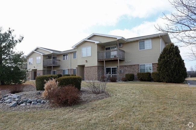
Property Record
25 Cherry Park Ct, Oshkosh, WI 54902

Save to a Folder
{{folder.Name}}
{{folder.ListingIds.length}} Properties
{{folder.ListingIds.length}} Property
Create a New Folder
Property Detail
25 Cherry Park Ct
14-16761400
LOT 14 CHERRY PARK ESTATES
Commercialnec
Winnebago
MR-20
Wisconsin
B and X Area of moderate flood hazard, usually the area between the limits of the 100-year and 500-year floods.
14
2024
7.36 AC
2025
Appleton/Oshkosh
001900
Other Market Areas
117,892 SF
Oshkosh-Neenah, WI
NEARBY LISTINGS FOR SALE OR LEASE
-
-
View all Oshkosh listings for sale on LoopNet.com
DEMOGRAPHICS near 25 Cherry Park Ct
1 mile
3 mile
5 mile
2025 Total Population
1,971
14,868
60,726
2030 Population
2,032
15,033
61,571
Pop Growth 2025-2030
+ 3.09%
+ 1.11%
+ 1.39%
Average Age
43
41
39
2025 Total Households
865
6,692
26,423
HH Growth 2025-2030
+ 3.12%
+ 1.06%
+ 1.52%
Median Household Inc
$73,629
$65,698
$60,898
Avg Household Size
2.20
2.20
2.10
2025 Avg HH Vehicles
2.00
2.00
2.00
Median Home Value
$329,675
$167,093
$179,088
Median Year Built
1989
1951
1968
Nearby Places
Map Layers
Map Styles
 Street
 Aerial
Layers
 Traffic
 Biking
Places
Listings with unknown addresses are not visible on the map
- Restaurants
- Banks
- Shops
- Fitness
- Groceries
PUBLIC TRANSPORTATION
AIRPORT
Appleton International
Drive
Walk
Distance
Appleton International
35 min
23.9 mi
Freight Ports
Port Milwaukee
Drive
Walk
Distance
Port Milwaukee
108 min
85.4 mi
Nearby Properties
Address
Land Use
TOTAL SIZE
Lot Size
Zoning
Address
Land Use
TOTAL SIZE
Lot Size
Zoning
7.74 AC
Address
Land Use
TOTAL SIZE
Lot Size
Zoning
58,465 SF
43.67 AC
M3
Address
Land Use
TOTAL SIZE
Lot Size
Zoning
570,585 SF
81.26 AC
M2
Address
Land Use
TOTAL SIZE
Lot Size
Zoning
18.38 AC
UIPD
Address
Land Use
TOTAL SIZE
Lot Size
Zoning
128,951 SF
4.95 AC
R1
Address
Land Use
TOTAL SIZE
Lot Size
Zoning
110,200 SF
14.77 AC
MR-12-PD
Address
Land Use
TOTAL SIZE
Lot Size
Zoning
19,488 SF
16.43 AC
C-2
Address
Land Use
TOTAL SIZE
Lot Size
Zoning
238,238 SF
22.60 AC
M3
Address
Land Use
TOTAL SIZE
Lot Size
Zoning
271,088 SF
36.80 AC
M3
Address
Land Use
TOTAL SIZE
Lot Size
Zoning
107,778 SF
8.57 AC
SMUPD
Address
Land Use
TOTAL SIZE
Lot Size
Zoning
92,958 SF
C2
Address
Land Use
TOTAL SIZE
Lot Size
Zoning
128,951 SF
1.15 AC
R1;SINGLE
Address
Land Use
TOTAL SIZE
Lot Size
Zoning
114,338 SF
10.20 AC
C2
Address
Land Use
TOTAL SIZE
Lot Size
Zoning
101,011 SF
16.53 AC
C3
Address
Land Use
TOTAL SIZE
Lot Size
Zoning
32,430 SF
7.44 AC
M1
Address
Land Use
TOTAL SIZE
Lot Size
Zoning
28,512 SF
6.20 AC
M1
Address
Land Use
TOTAL SIZE
Lot Size
Zoning
94,300 SF
1.21 AC
C3
Address
Land Use
TOTAL SIZE
Lot Size
Zoning
91,288 SF
7.29 AC
MR-12
Address
Land Use
TOTAL SIZE
Lot Size
Zoning
38,858 SF
8.15 AC
M1
Address
Land Use
TOTAL SIZE
Lot Size
Zoning
13.67 AC
Address
Land Use
TOTAL SIZE
Lot Size
Zoning
47,856 SF
5.26 AC
SMU-PD
Address
Land Use
TOTAL SIZE
Lot Size
Zoning
13.75 AC
Address
Land Use
TOTAL SIZE
Lot Size
Zoning
20,544 SF
4.16 AC
M-1PD
Address
Land Use
TOTAL SIZE
Lot Size
Zoning
254,308 SF
14.44 AC
M2
Address
Land Use
TOTAL SIZE
Lot Size
Zoning
54,672 SF
6.14 AC
NMU
Address
Land Use
TOTAL SIZE
Lot Size
Zoning
112,099 SF
8.64 AC
UMU
Address
Land Use
TOTAL SIZE
Lot Size
Zoning
31,298 SF
M3
Address
Land Use
TOTAL SIZE
Lot Size
Zoning
96,967 SF
3.42 AC
M2
Address
Land Use
TOTAL SIZE
Lot Size
Zoning
57,297 SF
3.23 AC
M1
The World's #1 Commercial Real Estate Marketplace
Connect with us
© 2026 CoStar Group
The information above has been obtained from sources believed reliable. While we do not doubt its accuracy we have not verified it and make no guarantee, warranty or representation about it. It is your responsibility to independently confirm its accuracy and completeness. Any projections, opinions, assumptions, or estimates used are for example only and do not represent the current or future performance of the property. The value of this transaction to you depends on tax and other factors which should be evaluated by your tax, financial, and legal advisors. You and your advisors should conduct a careful, independent investigation of the property to determine to your satisfaction the suitability of the property for your needs.