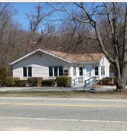
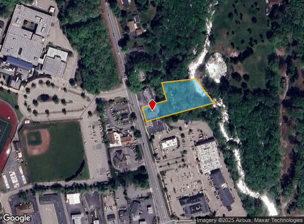
Property Record
25 Chesterfield Rd, East Lyme, CT 06333

NEARBY LISTINGS FOR SALE OR LEASE
Property Detail
25 Chesterfield Rd
Commercialbuilding
New London
AE
Connecticut
09011C0477J
1.17 AC
2025
SW New London/East Lyme
2025
Hartford
716102
Norwich-New London, CT
969 SF
ELYM-003101-000052
DEMOGRAPHICS near 25 Chesterfield Rd
1 Mile
3 Mile
5 Mile
2024 Total Population
2,794
14,007
38,281
2029 Population
2,766
13,963
38,483
Pop Growth 2024-2029
(1.00%)
(0.31%)
+ 0.53%
Average Age
44
45
45
2024 Total Households
1,115
5,829
15,884
HH Growth 2024-2029
(1.08%)
(0.31%)
+ 0.52%
Median Household Inc
$113,173
$107,817
$95,253
Avg Household Size
2.50
2.30
2.30
2024 Avg HH Vehicles
2.00
2.00
2.00
Median Home Value
$372,542
$354,594
$334,026
Median Year Built
1976
1973
1970
Nearby Places
Map Layers
Map Styles
 Street
 Aerial
- Restaurants
- Banks
- Shops
- Fitness
- Groceries
PUBLIC TRANSPORTATION
COMMUTER RAIL
New London (Shore Line East - Shore Line East)
DRIVE
WALK
Distance
New London (Shore Line East - Shore Line East)
11 min
7.0 mi
Freight Ports
Port of New Haven
DRIVE
WALK
Distance
Port of New Haven
49 min
39.5 mi
SALE & LEASE HISTORY
LISTING DATE
SALE/LEASE

Sep 23, 2016
For Sale
Nov 07, 2017
For Lease
Jul 12, 2023
For Lease
Nearby Properties
Address
Land Use
TOTAL SIZE
Lot Size
Zoning
Address
Land Use
TOTAL SIZE
Lot Size
Zoning
66.17 AC
LI
Address
Land Use
TOTAL SIZE
Lot Size
Zoning
35.08 AC
GDPP
Address
Land Use
TOTAL SIZE
Lot Size
Zoning
61.04 AC
CA
Address
Land Use
TOTAL SIZE
Lot Size
Zoning
47,148 SF
101.29 AC
IP-1
Address
Land Use
TOTAL SIZE
Lot Size
Zoning
68,244 SF
25.67 AC
R-40
Address
Land Use
TOTAL SIZE
Lot Size
Zoning
56.50 AC
C-R
Address
Land Use
TOTAL SIZE
Lot Size
Zoning
14.76 AC
CA
Address
Land Use
TOTAL SIZE
Lot Size
Zoning
79,469 SF
17.98 AC
IP-1
Address
Land Use
TOTAL SIZE
Lot Size
Zoning
70.27 AC
R-40
Address
Land Use
TOTAL SIZE
Lot Size
Zoning
201,755 SF
58.13 AC
C-R
Address
Land Use
TOTAL SIZE
Lot Size
Zoning
68,045 SF
15.56 AC
IP-1
Address
Land Use
TOTAL SIZE
Lot Size
Zoning
50,024 SF
10.35 AC
I-G
Address
Land Use
TOTAL SIZE
Lot Size
Zoning
106 AC
R40
Address
Land Use
TOTAL SIZE
Lot Size
Zoning
62,878 SF
6.01 AC
CA
Address
Land Use
TOTAL SIZE
Lot Size
Zoning
105,371 SF
11.50 AC
I-G
Address
Land Use
TOTAL SIZE
Lot Size
Zoning
45,288 SF
22.70 AC
I-G
Address
Land Use
TOTAL SIZE
Lot Size
Zoning
48,697 SF
3.83 AC
TC-80
Address
Land Use
TOTAL SIZE
Lot Size
Zoning
10.79 AC
R40
Address
Land Use
TOTAL SIZE
Lot Size
Zoning
26,955 SF
13.88 AC
I-G
Address
Land Use
TOTAL SIZE
Lot Size
Zoning
5.78 AC
I-G
Address
Land Use
TOTAL SIZE
Lot Size
Zoning
71,316 SF
8.01 AC
IP-3
Address
Land Use
TOTAL SIZE
Lot Size
Zoning
29,830 SF
4.85 AC
LI
Address
Land Use
TOTAL SIZE
Lot Size
Zoning
36,657 SF
4.56 AC
CA
Address
Land Use
TOTAL SIZE
Lot Size
Zoning
301.43 AC
SU-E
Address
Land Use
TOTAL SIZE
Lot Size
Zoning
95,111 SF
16.57 AC
I-G
Address
Land Use
TOTAL SIZE
Lot Size
Zoning
14,996 SF
1.10 AC
CA
Address
Land Use
TOTAL SIZE
Lot Size
Zoning
5.73 AC
CA
Address
Land Use
TOTAL SIZE
Lot Size
Zoning
323 SF
26.72 AC
IP-3
Address
Land Use
TOTAL SIZE
Lot Size
Zoning
11.50 AC
R40
Address
Land Use
TOTAL SIZE
Lot Size
Zoning
5.13 AC
CM
The World's #1 Commercial Real Estate Marketplace
Connect with us
© 2025 CoStar Group
The information above has been obtained from sources believed reliable. While we do not doubt its accuracy we have not verified it and make no guarantee, warranty or representation about it. It is your responsibility to independently confirm its accuracy and completeness. Any projections, opinions, assumptions, or estimates used are for example only and do not represent the current or future performance of the property. The value of this transaction to you depends on tax and other factors which should be evaluated by your tax, financial, and legal advisors. You and your advisors should conduct a careful, independent investigation of the property to determine to your satisfaction the suitability of the property for your needs.