Property Record
25 Circle Rd, San Rafael, CA 94903
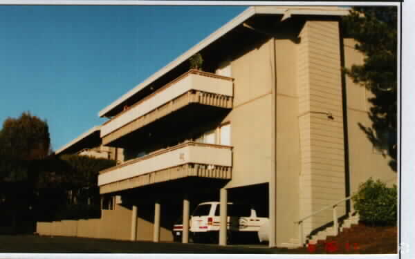

Property Detail
25 Circle Rd
San Rafael, CA
LOT 6
034-182-11
Marin
Multifamilydwelling
California
B and X Area of moderate flood hazard, usually the area between the limits of the 100-year and 500-year floods.
6
2025
0.23 AC
2025
Outer Mill Vly/Corte Madera/Sausalito
124100
North Bay/Santa Rosa
6,471 SF
NEARBY LISTINGS FOR SALE OR LEASE
DEMOGRAPHICS near 25 Circle Rd
1 mile
3 mile
5 mile
2025 Total Population
8,189
57,391
101,232
2030 Population
8,124
56,816
100,067
Pop Growth 2025-2030
(0.79%)
(1.00%)
(1.15%)
Average Age
45
46
45
2025 Total Households
3,449
24,234
41,078
HH Growth 2025-2030
(0.70%)
(1.04%)
(1.11%)
Median Household Inc
$154,687
$195,359
$169,434
Avg Household Size
2.30
2.30
2.40
2025 Avg HH Vehicles
2.00
2.00
2.00
Median Home Value
$1,134,436
$1,130,810
$1,125,824
Median Year Built
1965
1965
1965
Nearby Places
Map Layers
Map Styles
 Street
 Aerial
Transit
 Traffic
 Biking
Places
Listings with unknown addresses are not visible on the map
- Restaurants
- Banks
- Shops
- Fitness
- Groceries
PUBLIC TRANSPORTATION
COMMUTER RAIL
Smart Marin Civic Center (Main Line - Sonoma Marin Area Rail Transit)
Drive
Walk
Distance
Smart Marin Civic Center (Main Line - Sonoma Marin Area Rail Transit)
4 min
16 min
0.8 mi
Smart San Rafael (Main Line - Sonoma Marin Area Rail Transit)
Drive
Walk
Distance
Smart San Rafael (Main Line - Sonoma Marin Area Rail Transit)
5 min
2.5 mi
AIRPORT
San Francisco International
Drive
Walk
Distance
San Francisco International
53 min
33.2 mi
Metro Oakland International
Drive
Walk
Distance
Metro Oakland International
45 min
33.3 mi
Freight Ports
Port of Richmond
Drive
Walk
Distance
Port of Richmond
23 min
14.0 mi
Nearby Properties
Address
Land Use
TOTAL SIZE
Lot Size
Zoning
Address
Land Use
TOTAL SIZE
Lot Size
Zoning
283,663 SF
27.98 AC
Address
Land Use
TOTAL SIZE
Lot Size
Zoning
23.79 AC
Address
Land Use
TOTAL SIZE
Lot Size
Zoning
87,058 SF
1.33 AC
Address
Land Use
TOTAL SIZE
Lot Size
Zoning
221,660 SF
9.69 AC
PC
Address
Land Use
TOTAL SIZE
Lot Size
Zoning
146,832 SF
5.50 AC
Address
Land Use
TOTAL SIZE
Lot Size
Zoning
167,392 SF
12.79 AC
Address
Land Use
TOTAL SIZE
Lot Size
Zoning
147,502 SF
1.02 AC
Address
Land Use
TOTAL SIZE
Lot Size
Zoning
132,040 SF
11.74 AC
Address
Land Use
TOTAL SIZE
Lot Size
Zoning
11.63 AC
Address
Land Use
TOTAL SIZE
Lot Size
Zoning
91,158 SF
1.89 AC
Address
Land Use
TOTAL SIZE
Lot Size
Zoning
15.91 AC
SPD
Address
Land Use
TOTAL SIZE
Lot Size
Zoning
94,745 SF
1.46 AC
Address
Land Use
TOTAL SIZE
Lot Size
Zoning
75,888 SF
10.99 AC
Address
Land Use
TOTAL SIZE
Lot Size
Zoning
195,460 SF
6.10 AC
Address
Land Use
TOTAL SIZE
Lot Size
Zoning
71,527 SF
1.86 AC
Address
Land Use
TOTAL SIZE
Lot Size
Zoning
Address
Land Use
TOTAL SIZE
Lot Size
Zoning
84,245 SF
2.62 AC
Address
Land Use
TOTAL SIZE
Lot Size
Zoning
177,460 SF
13 AC
Address
Land Use
TOTAL SIZE
Lot Size
Zoning
11,830 SF
0.65 AC
Address
Land Use
TOTAL SIZE
Lot Size
Zoning
85,066 SF
1.29 AC
Address
Land Use
TOTAL SIZE
Lot Size
Zoning
48,603 SF
2.54 AC
Address
Land Use
TOTAL SIZE
Lot Size
Zoning
87,840 SF
1.19 AC
Address
Land Use
TOTAL SIZE
Lot Size
Zoning
33,641 SF
1.60 AC
Address
Land Use
TOTAL SIZE
Lot Size
Zoning
45,142 SF
2.32 AC
Address
Land Use
TOTAL SIZE
Lot Size
Zoning
6.39 AC
Address
Land Use
TOTAL SIZE
Lot Size
Zoning
142,341 SF
5.83 AC
Address
Land Use
TOTAL SIZE
Lot Size
Zoning
66,700 SF
0.99 AC
Address
Land Use
TOTAL SIZE
Lot Size
Zoning
42,410 SF
0.54 AC
Address
Land Use
TOTAL SIZE
Lot Size
Zoning
75,556 SF
0.78 AC
Address
Land Use
TOTAL SIZE
Lot Size
Zoning
2.53 AC
The World's #1 Commercial Real Estate Marketplace
Connect with us
© 2026 CoStar Group
The information above has been obtained from sources believed reliable. While we do not doubt its accuracy we have not verified it and make no guarantee, warranty or representation about it. It is your responsibility to independently confirm its accuracy and completeness. Any projections, opinions, assumptions, or estimates used are for example only and do not represent the current or future performance of the property. The value of this transaction to you depends on tax and other factors which should be evaluated by your tax, financial, and legal advisors. You and your advisors should conduct a careful, independent investigation of the property to determine to your satisfaction the suitability of the property for your needs.