Property Record
25 Computer Dr, Haverhill, MA 01832
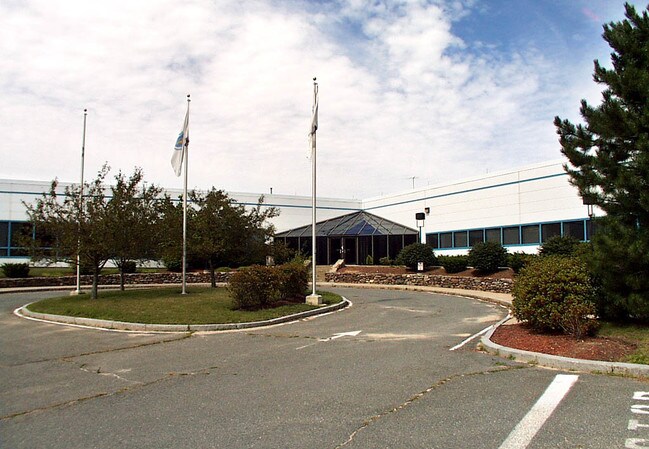

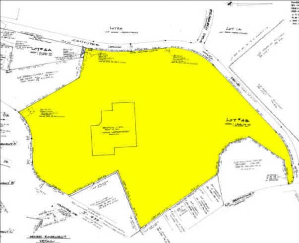
Property Detail
25 Computer Dr
HAVE-000548-000001-000010
Essex
Commercialbuilding
Massachusetts
B and X Area of moderate flood hazard, usually the area between the limits of the 100-year and 500-year floods.
10
2025
20.99 AC
2025
Lawrence/Andover
260402
Boston
142,845 SF
Boston-Cambridge-Newton, MA-NH
NEARBY LISTINGS FOR SALE OR LEASE
DEMOGRAPHICS near 25 Computer Dr
1 mile
3 mile
5 mile
2025 Total Population
6,625
62,862
120,837
2030 Population
6,785
63,923
123,079
Pop Growth 2025-2030
+ 2.42%
+ 1.69%
+ 1.86%
Average Age
41
41
42
2025 Total Households
2,531
24,874
46,623
HH Growth 2025-2030
+ 2.37%
+ 1.70%
+ 1.80%
Median Household Inc
$86,070
$80,007
$97,206
Avg Household Size
2.50
2.40
2.50
2025 Avg HH Vehicles
2.00
2.00
2.00
Median Home Value
$421,584
$456,157
$481,446
Median Year Built
1977
1964
1971
Nearby Places
Map Layers
Map Styles
 Street
 Aerial
Transit
 Traffic
 Biking
Places
Listings with unknown addresses are not visible on the map
- Restaurants
- Banks
- Shops
- Fitness
- Groceries
PUBLIC TRANSPORTATION
COMMUTER RAIL
Haverhill (Haverhill Line - Massachusetts Bay Transportation Authority Commuter Rail (Purple Line))
Drive
Walk
Distance
Haverhill (Haverhill Line - Massachusetts Bay Transportation Authority Commuter Rail (Purple Line))
6 min
2.5 mi
Bradford (Haverhill Line - Massachusetts Bay Transportation Authority Commuter Rail (Purple Line))
Drive
Walk
Distance
Bradford (Haverhill Line - Massachusetts Bay Transportation Authority Commuter Rail (Purple Line))
7 min
3.0 mi
AIRPORT
Manchester Boston Regional
Drive
Walk
Distance
Manchester Boston Regional
47 min
29.9 mi
Portsmouth International at Pease
Drive
Walk
Distance
Portsmouth International at Pease
44 min
31.8 mi
General Edward Lawrence Logan International
Drive
Walk
Distance
General Edward Lawrence Logan International
51 min
37.0 mi
Freight Ports
Port of Boston
Drive
Walk
Distance
Port of Boston
52 min
36.8 mi
Nearby Properties
Address
Land Use
TOTAL SIZE
Lot Size
Zoning
Address
Land Use
TOTAL SIZE
Lot Size
Zoning
3,000 SF
44.13 AC
IL
Address
Land Use
TOTAL SIZE
Lot Size
Zoning
32.32 AC
Address
Land Use
TOTAL SIZE
Lot Size
Zoning
232,420 SF
4.58 AC
Address
Land Use
TOTAL SIZE
Lot Size
Zoning
358,890 SF
5.72 AC
Address
Land Use
TOTAL SIZE
Lot Size
Zoning
Address
Land Use
TOTAL SIZE
Lot Size
Zoning
195,120 SF
9.05 AC
Address
Land Use
TOTAL SIZE
Lot Size
Zoning
226,309 SF
19.33 AC
R3
Address
Land Use
TOTAL SIZE
Lot Size
Zoning
187,600 SF
19.31 AC
Address
Land Use
TOTAL SIZE
Lot Size
Zoning
169,340 SF
14.95 AC
C-1
Address
Land Use
TOTAL SIZE
Lot Size
Zoning
173,788 SF
16.30 AC
Address
Land Use
TOTAL SIZE
Lot Size
Zoning
21.91 AC
Address
Land Use
TOTAL SIZE
Lot Size
Zoning
19.90 AC
Address
Land Use
TOTAL SIZE
Lot Size
Zoning
121,231 SF
1.11 AC
Address
Land Use
TOTAL SIZE
Lot Size
Zoning
125,627 SF
46.02 AC
C-1
Address
Land Use
TOTAL SIZE
Lot Size
Zoning
200,081 SF
1.95 AC
Address
Land Use
TOTAL SIZE
Lot Size
Zoning
72,019 SF
10.74 AC
Address
Land Use
TOTAL SIZE
Lot Size
Zoning
21,752 SF
5.28 AC
Address
Land Use
TOTAL SIZE
Lot Size
Zoning
35,633 SF
19.15 AC
C-1
Address
Land Use
TOTAL SIZE
Lot Size
Zoning
26.60 AC
Address
Land Use
TOTAL SIZE
Lot Size
Zoning
17.95 AC
Address
Land Use
TOTAL SIZE
Lot Size
Zoning
201,526 SF
24 AC
Address
Land Use
TOTAL SIZE
Lot Size
Zoning
5.82 AC
Address
Land Use
TOTAL SIZE
Lot Size
Zoning
106,323 SF
2.05 AC
Address
Land Use
TOTAL SIZE
Lot Size
Zoning
102,352 SF
19.50 AC
Address
Land Use
TOTAL SIZE
Lot Size
Zoning
69,094 SF
0.54 AC
Address
Land Use
TOTAL SIZE
Lot Size
Zoning
119,956 SF
9.54 AC
Address
Land Use
TOTAL SIZE
Lot Size
Zoning
88,943 SF
2.43 AC
Address
Land Use
TOTAL SIZE
Lot Size
Zoning
202,022 SF
13.29 AC
Address
Land Use
TOTAL SIZE
Lot Size
Zoning
126,618 SF
17.47 AC
The World's #1 Commercial Real Estate Marketplace
Connect with us
© 2026 CoStar Group
The information above has been obtained from sources believed reliable. While we do not doubt its accuracy we have not verified it and make no guarantee, warranty or representation about it. It is your responsibility to independently confirm its accuracy and completeness. Any projections, opinions, assumptions, or estimates used are for example only and do not represent the current or future performance of the property. The value of this transaction to you depends on tax and other factors which should be evaluated by your tax, financial, and legal advisors. You and your advisors should conduct a careful, independent investigation of the property to determine to your satisfaction the suitability of the property for your needs.