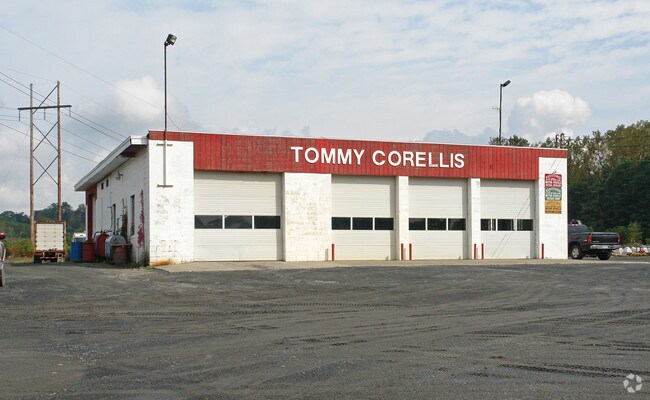
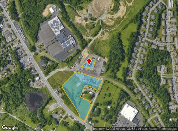
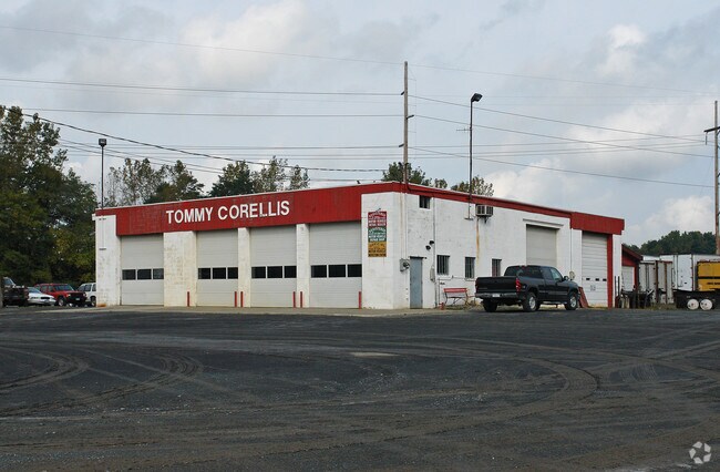
Property Record
25 Corellis Dr, Rensselaer, NY 12144
NEARBY LISTINGS FOR SALE OR LEASE
Property Detail
25 Corellis Dr
2400-166-3-2.1
Rensselaer
Truckterminal
New York
ARE
2.001
36083C0351D
8.23 AC
2025
Outer Rensselaer County
2024
Albany/Schenectady/Troy
052406
Albany-Schenectady-Troy, NY
4,340 SF
DEMOGRAPHICS near 25 Corellis Dr
1 Mile
3 Mile
5 Mile
2024 Total Population
5,252
27,715
108,116
2029 Population
5,187
27,426
106,837
Pop Growth 2024-2029
(1.24%)
(1.04%)
(1.18%)
Average Age
42
41
39
2024 Total Households
2,210
11,910
47,390
HH Growth 2024-2029
(1.36%)
(1.17%)
(1.18%)
Median Household Inc
$92,243
$77,590
$63,215
Avg Household Size
2.30
2.20
2.10
2024 Avg HH Vehicles
2.00
2.00
1.00
Median Home Value
$211,527
$228,933
$229,684
Median Year Built
1970
1967
1958
Nearby Places
- Restaurants
- Banks
- Shops
- Fitness
- Groceries
PUBLIC TRANSPORTATION
COMMUTER RAIL
DRIVE
WALK
Distance
8 min
2.9 mi
AIRPORT
Albany International
DRIVE
WALK
Distance
Albany International
30 min
16.3 mi
Freight Ports
Albany, NY Port
DRIVE
WALK
Distance
Albany, NY Port
13 min
5.2 mi
Nearby Properties
Address
Land Use
TOTAL SIZE
Lot Size
Zoning
Address
Land Use
TOTAL SIZE
Lot Size
Zoning
33.88 AC
I2
Address
Land Use
TOTAL SIZE
Lot Size
Zoning
83.50 AC
Address
Land Use
TOTAL SIZE
Lot Size
Zoning
296,914 SF
68.73 AC
PDD
Address
Land Use
TOTAL SIZE
Lot Size
Zoning
179,713 SF
126.43 AC
OC
Address
Land Use
TOTAL SIZE
Lot Size
Zoning
104,077 SF
6.64 AC
B-2
Address
Land Use
TOTAL SIZE
Lot Size
Zoning
316,634 SF
27.82 AC
OI
Address
Land Use
TOTAL SIZE
Lot Size
Zoning
161,972 SF
26.62 AC
OI
Address
Land Use
TOTAL SIZE
Lot Size
Zoning
171,096 SF
18.04 AC
B-2
Address
Land Use
TOTAL SIZE
Lot Size
Zoning
194,018 SF
73.71 AC
R-B
Address
Land Use
TOTAL SIZE
Lot Size
Zoning
2.25 AC
Address
Land Use
TOTAL SIZE
Lot Size
Zoning
5,776 SF
90.90 AC
M1
Address
Land Use
TOTAL SIZE
Lot Size
Zoning
44,712 SF
25.58 AC
R-3
Address
Land Use
TOTAL SIZE
Lot Size
Zoning
62,714 SF
8.74 AC
OI
Address
Land Use
TOTAL SIZE
Lot Size
Zoning
27,612 SF
11.60 AC
M1
Address
Land Use
TOTAL SIZE
Lot Size
Zoning
99,223 SF
15.47 AC
R-B
Address
Land Use
TOTAL SIZE
Lot Size
Zoning
204,692 SF
30.97 AC
OC
Address
Land Use
TOTAL SIZE
Lot Size
Zoning
100,176 SF
3.23 AC
C1
Address
Land Use
TOTAL SIZE
Lot Size
Zoning
20.10 AC
M1
Address
Land Use
TOTAL SIZE
Lot Size
Zoning
64,600 SF
13.16 AC
Address
Land Use
TOTAL SIZE
Lot Size
Zoning
0.01 AC
I
Address
Land Use
TOTAL SIZE
Lot Size
Zoning
62,039 SF
5.02 AC
O
Address
Land Use
TOTAL SIZE
Lot Size
Zoning
130,876 SF
26.03 AC
R-2
Address
Land Use
TOTAL SIZE
Lot Size
Zoning
40,888 SF
31.40 AC
M1
Address
Land Use
TOTAL SIZE
Lot Size
Zoning
115,428 SF
5.90 AC
R3B
Address
Land Use
TOTAL SIZE
Lot Size
Zoning
47,284 SF
0.18 AC
C3
Address
Land Use
TOTAL SIZE
Lot Size
Zoning
120,000 SF
11.77 AC
OC
Address
Land Use
TOTAL SIZE
Lot Size
Zoning
83,312 SF
0.68 AC
CM
Address
Land Use
TOTAL SIZE
Lot Size
Zoning
36,046 SF
10.79 AC
R2A
Address
Land Use
TOTAL SIZE
Lot Size
Zoning
6,720 SF
15.68 AC
R-3
Address
Land Use
TOTAL SIZE
Lot Size
Zoning
53.70 AC
R2B
The World's #1 Commercial Real Estate Marketplace
Connect with us
© 2025 CoStar Group
The information above has been obtained from sources believed reliable. While we do not doubt its accuracy we have not verified it and make no guarantee, warranty or representation about it. It is your responsibility to independently confirm its accuracy and completeness. Any projections, opinions, assumptions, or estimates used are for example only and do not represent the current or future performance of the property. The value of this transaction to you depends on tax and other factors which should be evaluated by your tax, financial, and legal advisors. You and your advisors should conduct a careful, independent investigation of the property to determine to your satisfaction the suitability of the property for your needs.