Property Record
25 E 16Th St, Chicago Heights, IL 60411
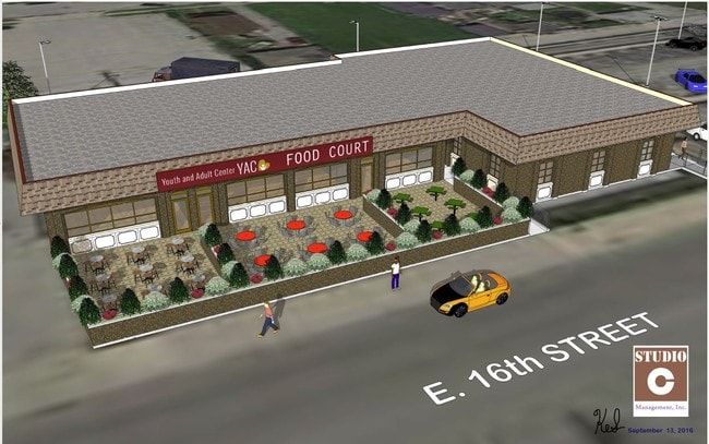
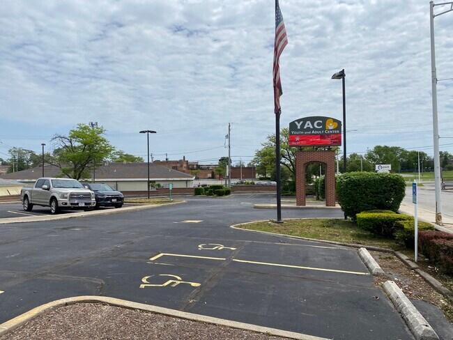

This Property Is For Sale
Property Detail
25 E 16Th St
Chicago-Naperville-Elgin, IL-IN
Cook
32-20-416-016-0000
Illinois
Taxexempt
11,12
B and X Area of moderate flood hazard, usually the area between the limits of the 100-year and 500-year floods.
0.15 AC
2021
Far South
2025
Chicago
828900
NEARBY LISTINGS FOR SALE OR LEASE
DEMOGRAPHICS near 25 E 16Th St
1 mile
3 mile
5 mile
2025 Total Population
15,070
71,473
170,714
2030 Population
15,822
73,261
174,099
Pop Growth 2025-2030
+ 4.99%
+ 2.50%
+ 1.98%
Average Age
37
40
41
2025 Total Households
4,900
26,080
63,473
HH Growth 2025-2030
+ 4.90%
+ 2.20%
+ 1.75%
Median Household Inc
$48,284
$60,011
$69,935
Avg Household Size
2.90
2.60
2.60
2025 Avg HH Vehicles
2.00
2.00
2.00
Median Home Value
$140,487
$150,880
$180,053
Median Year Built
1957
1962
1967
Nearby Places
Map Layers
Map Styles
 Street
 Aerial
Layers
 Traffic
 Biking
Places
Listings with unknown addresses are not visible on the map
- Restaurants
- Banks
- Shops
- Fitness
- Groceries
PUBLIC TRANSPORTATION
COMMUTER RAIL
211Th Street (Lincoln Highway) Station (Metra Electric Line - Northeast Illinois Regional Commuter Railroad (Metra))
Drive
Walk
Distance
211Th Street (Lincoln Highway) Station (Metra Electric Line - Northeast Illinois Regional Commuter Railroad (Metra))
7 min
3.3 mi
Olympia Fields Station (Metra Electric Line - Northeast Illinois Regional Commuter Railroad (Metra))
Drive
Walk
Distance
Olympia Fields Station (Metra Electric Line - Northeast Illinois Regional Commuter Railroad (Metra))
9 min
4.7 mi
AIRPORT
Chicago Midway International
Drive
Walk
Distance
Chicago Midway International
39 min
23.5 mi
Freight Ports
Port Milwaukee
Drive
Walk
Distance
Port Milwaukee
145 min
117.0 mi
Nearby Properties
Address
Land Use
TOTAL SIZE
Lot Size
Zoning
Address
Land Use
TOTAL SIZE
Lot Size
Zoning
Address
Land Use
TOTAL SIZE
Lot Size
Zoning
78,884 SF
5.60 AC
Address
Land Use
TOTAL SIZE
Lot Size
Zoning
49,866 SF
5.57 AC
Address
Land Use
TOTAL SIZE
Lot Size
Zoning
Address
Land Use
TOTAL SIZE
Lot Size
Zoning
31,952 SF
4.03 AC
Address
Land Use
TOTAL SIZE
Lot Size
Zoning
15.23 AC
Address
Land Use
TOTAL SIZE
Lot Size
Zoning
2,845,012 SF
133.73 AC
Address
Land Use
TOTAL SIZE
Lot Size
Zoning
Address
Land Use
TOTAL SIZE
Lot Size
Zoning
304,256 SF
21.50 AC
Address
Land Use
TOTAL SIZE
Lot Size
Zoning
183,041 SF
18.71 AC
Address
Land Use
TOTAL SIZE
Lot Size
Zoning
26.61 AC
Address
Land Use
TOTAL SIZE
Lot Size
Zoning
90,908 SF
1.78 AC
Address
Land Use
TOTAL SIZE
Lot Size
Zoning
628 SF
4.91 AC
Address
Land Use
TOTAL SIZE
Lot Size
Zoning
Address
Land Use
TOTAL SIZE
Lot Size
Zoning
Address
Land Use
TOTAL SIZE
Lot Size
Zoning
3.93 AC
Address
Land Use
TOTAL SIZE
Lot Size
Zoning
37,309 SF
1.50 AC
Address
Land Use
TOTAL SIZE
Lot Size
Zoning
44,000 SF
1.44 AC
Address
Land Use
TOTAL SIZE
Lot Size
Zoning
189,489 SF
20 AC
Address
Land Use
TOTAL SIZE
Lot Size
Zoning
182,300 SF
144.71 AC
Address
Land Use
TOTAL SIZE
Lot Size
Zoning
49,800 SF
4.42 AC
Address
Land Use
TOTAL SIZE
Lot Size
Zoning
24,508 SF
1.13 AC
Address
Land Use
TOTAL SIZE
Lot Size
Zoning
562,369 SF
50 AC
Address
Land Use
TOTAL SIZE
Lot Size
Zoning
Address
Land Use
TOTAL SIZE
Lot Size
Zoning
6,350 SF
1.16 AC
Address
Land Use
TOTAL SIZE
Lot Size
Zoning
Address
Land Use
TOTAL SIZE
Lot Size
Zoning
284,100 SF
12.60 AC
Address
Land Use
TOTAL SIZE
Lot Size
Zoning
Address
Land Use
TOTAL SIZE
Lot Size
Zoning
234,478 SF
13.22 AC
Address
Land Use
TOTAL SIZE
Lot Size
Zoning
139,936 SF
73.19 AC
The World's #1 Commercial Real Estate Marketplace
Connect with us
© 2026 CoStar Group
The information above has been obtained from sources believed reliable. While we do not doubt its accuracy we have not verified it and make no guarantee, warranty or representation about it. It is your responsibility to independently confirm its accuracy and completeness. Any projections, opinions, assumptions, or estimates used are for example only and do not represent the current or future performance of the property. The value of this transaction to you depends on tax and other factors which should be evaluated by your tax, financial, and legal advisors. You and your advisors should conduct a careful, independent investigation of the property to determine to your satisfaction the suitability of the property for your needs.