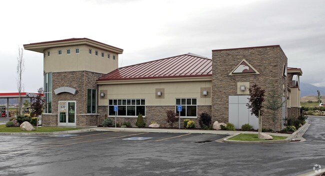
Property Record
25 E Crossroads Blvd, Saratoga Springs, UT 84045


NEARBY LISTINGS FOR SALE OR LEASE
Property Detail
25 E Crossroads Blvd
Salt Lake City
Ross
Provo-Orem, UT
PART LOT 2, SARATOGA CROSSROADS SUB DESCRIBED AS FOLLOWS: AREA 1.250 AC.
52-965-0013
Utah
Financialbuilding
Utah
2024
2
2025
1.25 AC
010124
Utah County
5,066 SF
DEMOGRAPHICS near 25 E Crossroads Blvd
1 Mile
3 Mile
5 Mile
2024 Total Population
11,374
65,951
157,014
2029 Population
13,513
78,153
185,398
Pop Growth 2024-2029
+ 18.81%
+ 18.50%
+ 18.08%
Average Age
26
27
28
2024 Total Households
3,234
17,486
41,015
HH Growth 2024-2029
+ 19.29%
+ 19.11%
+ 18.56%
Median Household Inc
$108,835
$111,974
$111,801
Avg Household Size
3.50
3.80
3.80
2024 Avg HH Vehicles
2.00
2.00
2.00
Median Home Value
$447,368
$473,478
$487,716
Median Year Built
2010
2010
2010
Nearby Places
Map Layers
Map Styles
 Street
 Aerial
- Restaurants
- Banks
- Shops
- Fitness
- Groceries
PUBLIC TRANSPORTATION
COMMUTER RAIL
Lehi Station (FrontRunner - Utah Transit Authority (UTA))
DRIVE
WALK
Distance
Lehi Station (FrontRunner - Utah Transit Authority (UTA))
10 min
4.9 mi
American Fork Station (FrontRunner - Utah Transit Authority (UTA))
DRIVE
WALK
Distance
American Fork Station (FrontRunner - Utah Transit Authority (UTA))
13 min
7.0 mi
AIRPORT
Provo Municipal
DRIVE
WALK
Distance
Provo Municipal
32 min
22.5 mi
Salt Lake City International
DRIVE
WALK
Distance
Salt Lake City International
43 min
34.5 mi
Freight Ports
Port of Stockton
DRIVE
WALK
Distance
Port of Stockton
739 min
712.2 mi
Nearby Properties
Address
Land Use
TOTAL SIZE
Lot Size
Zoning
Address
Land Use
TOTAL SIZE
Lot Size
Zoning
36.17 AC
Address
Land Use
TOTAL SIZE
Lot Size
Zoning
166,233 SF
8.70 AC
Address
Land Use
TOTAL SIZE
Lot Size
Zoning
247,594 SF
19.01 AC
Address
Land Use
TOTAL SIZE
Lot Size
Zoning
216,478 SF
7.38 AC
Address
Land Use
TOTAL SIZE
Lot Size
Zoning
215,516 SF
4.93 AC
Address
Land Use
TOTAL SIZE
Lot Size
Zoning
139,088 SF
9.14 AC
Address
Land Use
TOTAL SIZE
Lot Size
Zoning
149,591 SF
7.07 AC
Address
Land Use
TOTAL SIZE
Lot Size
Zoning
293,170 SF
9.60 AC
Address
Land Use
TOTAL SIZE
Lot Size
Zoning
266,041 SF
11.28 AC
Address
Land Use
TOTAL SIZE
Lot Size
Zoning
150,068 SF
5.05 AC
Address
Land Use
TOTAL SIZE
Lot Size
Zoning
146,675 SF
1.09 AC
Address
Land Use
TOTAL SIZE
Lot Size
Zoning
61,537 SF
3 AC
Address
Land Use
TOTAL SIZE
Lot Size
Zoning
98,726 SF
2.85 AC
Address
Land Use
TOTAL SIZE
Lot Size
Zoning
198,068 SF
20.72 AC
Address
Land Use
TOTAL SIZE
Lot Size
Zoning
159,119 SF
8.47 AC
Address
Land Use
TOTAL SIZE
Lot Size
Zoning
123,381 SF
12.30 AC
Address
Land Use
TOTAL SIZE
Lot Size
Zoning
134,637 SF
16.98 AC
Address
Land Use
TOTAL SIZE
Lot Size
Zoning
99,862 SF
10.92 AC
Address
Land Use
TOTAL SIZE
Lot Size
Zoning
102,380 SF
9.10 AC
Address
Land Use
TOTAL SIZE
Lot Size
Zoning
109,514 SF
7.80 AC
Address
Land Use
TOTAL SIZE
Lot Size
Zoning
64,605 SF
8.11 AC
Address
Land Use
TOTAL SIZE
Lot Size
Zoning
43,638 SF
40.32 AC
Address
Land Use
TOTAL SIZE
Lot Size
Zoning
90,049 SF
5.99 AC
Address
Land Use
TOTAL SIZE
Lot Size
Zoning
11,050 SF
19.23 AC
Address
Land Use
TOTAL SIZE
Lot Size
Zoning
120,431 SF
7.92 AC
Address
Land Use
TOTAL SIZE
Lot Size
Zoning
59,672 SF
3.24 AC
Address
Land Use
TOTAL SIZE
Lot Size
Zoning
96,361 SF
7.86 AC
Address
Land Use
TOTAL SIZE
Lot Size
Zoning
47,237 SF
4.14 AC
Address
Land Use
TOTAL SIZE
Lot Size
Zoning
87,141 SF
6.02 AC
The World's #1 Commercial Real Estate Marketplace
Connect with us
© 2026 CoStar Group
The information above has been obtained from sources believed reliable. While we do not doubt its accuracy we have not verified it and make no guarantee, warranty or representation about it. It is your responsibility to independently confirm its accuracy and completeness. Any projections, opinions, assumptions, or estimates used are for example only and do not represent the current or future performance of the property. The value of this transaction to you depends on tax and other factors which should be evaluated by your tax, financial, and legal advisors. You and your advisors should conduct a careful, independent investigation of the property to determine to your satisfaction the suitability of the property for your needs.