Property Record
25 E Merrick Rd, Valley Stream, NY 11580


Save to a Folder
{{folder.Name}}
{{folder.ListingIds.length}} Properties
{{folder.ListingIds.length}} Property
Create a New Folder
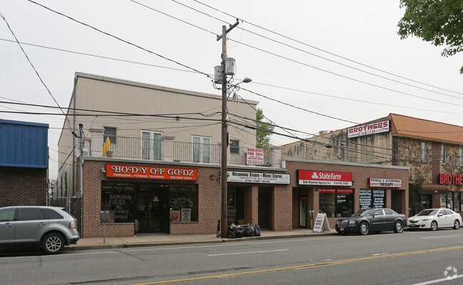
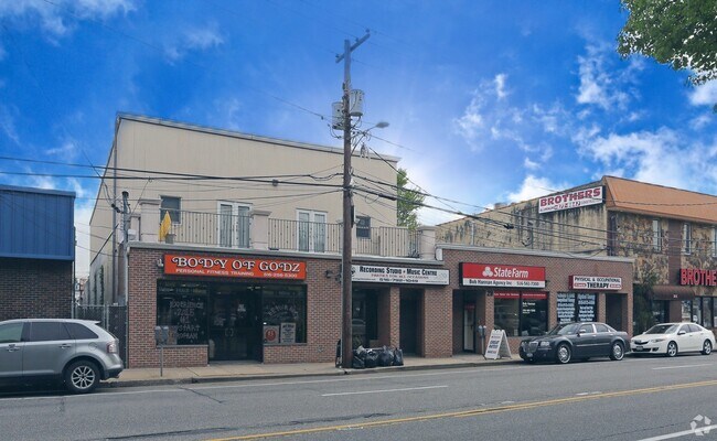
Property Detail
25 E Merrick Rd
Nassau County-Suffolk County, NY
TOWN #1 SCH DIST 013
2035-37-094-00-0034-0
Nassau
Officebuilding
New York
C and X Area of minimal flood hazard, usually depicted on FIRMs as above the 500-year flood level.
34-35
2025
0.12 AC
2026
Southern Nassau
410500
Long Island (New York)
11,090 SF
NEARBY LISTINGS FOR SALE OR LEASE
DEMOGRAPHICS near 25 E Merrick Rd
1 mile
3 mile
5 mile
2025 Total Population
30,861
259,654
676,932
2030 Population
30,496
255,905
666,062
Pop Growth 2025-2030
(1.18%)
(1.44%)
(1.61%)
Average Age
41
42
42
2025 Total Households
9,807
82,204
211,389
HH Growth 2025-2030
(1.33%)
(1.61%)
(1.85%)
Median Household Inc
$125,686
$131,533
$118,250
Avg Household Size
3.00
3.10
3.10
2025 Avg HH Vehicles
2.00
2.00
2.00
Median Home Value
$708,463
$714,623
$718,525
Median Year Built
1948
1952
1951
Nearby Places
Map Layers
Map Styles
 Street
 Aerial
Layers
 Traffic
 Biking
Places
Listings with unknown addresses are not visible on the map
- Restaurants
- Banks
- Shops
- Fitness
- Groceries
PUBLIC TRANSPORTATION
COMMUTER RAIL
Valley Stream Station (Far Rockaway Branch - Long Island Rail Road, Long Beach Branch - Long Island Rail Road, West Hempstead Branch - Long Island Rail Road)
Drive
Walk
Distance
Valley Stream Station (Far Rockaway Branch - Long Island Rail Road, Long Beach Branch - Long Island Rail Road, West Hempstead Branch - Long Island Rail Road)
2 min
12 min
0.7 mi
Westwood Station (West Hempstead Branch - Long Island Rail Road)
Drive
Walk
Distance
Westwood Station (West Hempstead Branch - Long Island Rail Road)
3 min
19 min
1.0 mi
AIRPORT
John F Kennedy International
Drive
Walk
Distance
John F Kennedy International
13 min
7.5 mi
LaGuardia
Drive
Walk
Distance
LaGuardia
23 min
14.5 mi
Newark Liberty International
Drive
Walk
Distance
Newark Liberty International
50 min
34.2 mi
Freight Ports
NY - Red Hook Container Terminal
Drive
Walk
Distance
NY - Red Hook Container Terminal
34 min
18.9 mi
SALE & LEASE HISTORY
LISTING DATE
SALE/LEASE

May 18, 2017
For Sale
May 18, 2017
For Sale
Mar 28, 2017
For Sale
Mar 19, 2019
For Lease
Jul 24, 2019
For Sale
Jul 08, 2021
For Lease
Feb 06, 2018
For Sale
Nearby Properties
Address
Land Use
TOTAL SIZE
Lot Size
Zoning
Address
Land Use
TOTAL SIZE
Lot Size
Zoning
27.23 AC
PARK
Address
Land Use
TOTAL SIZE
Lot Size
Zoning
129,378 SF
4.86 AC
R2A
Address
Land Use
TOTAL SIZE
Lot Size
Zoning
64,618 SF
8.04 AC
Address
Land Use
TOTAL SIZE
Lot Size
Zoning
93.35 AC
PARK
Address
Land Use
TOTAL SIZE
Lot Size
Zoning
5,296 SF
37.42 AC
PARK
Address
Land Use
TOTAL SIZE
Lot Size
Zoning
213,338 SF
2.91 AC
R3X
Address
Land Use
TOTAL SIZE
Lot Size
Zoning
97,190 SF
1.75 AC
R3X
Address
Land Use
TOTAL SIZE
Lot Size
Zoning
260,000 SF
4.14 AC
R2
Address
Land Use
TOTAL SIZE
Lot Size
Zoning
78,380 SF
0.85 AC
R3-2
Address
Land Use
TOTAL SIZE
Lot Size
Zoning
85,330 SF
2.91 AC
R3-2
Address
Land Use
TOTAL SIZE
Lot Size
Zoning
131,000 SF
2.43 AC
M1-1
Address
Land Use
TOTAL SIZE
Lot Size
Zoning
4,000 SF
23.88 AC
PARK
Address
Land Use
TOTAL SIZE
Lot Size
Zoning
61,123 SF
0.56 AC
R5D
Address
Land Use
TOTAL SIZE
Lot Size
Zoning
59,963 SF
1.55 AC
M1-1
Address
Land Use
TOTAL SIZE
Lot Size
Zoning
73,300 SF
1.93 AC
R2
Address
Land Use
TOTAL SIZE
Lot Size
Zoning
55,392 SF
1.71 AC
R3-1
Address
Land Use
TOTAL SIZE
Lot Size
Zoning
41,712 SF
0.51 AC
R2A
Address
Land Use
TOTAL SIZE
Lot Size
Zoning
108,350 SF
4.88 AC
R3-2
Address
Land Use
TOTAL SIZE
Lot Size
Zoning
79,200 SF
2.30 AC
R2A
Address
Land Use
TOTAL SIZE
Lot Size
Zoning
1,594 SF
1.01 AC
R2A
Address
Land Use
TOTAL SIZE
Lot Size
Zoning
67,400 SF
1.84 AC
M1-1
Address
Land Use
TOTAL SIZE
Lot Size
Zoning
2,634,357 SF
57.63 AC
Address
Land Use
TOTAL SIZE
Lot Size
Zoning
28.12 AC
R3-2
Address
Land Use
TOTAL SIZE
Lot Size
Zoning
13,334 SF
2.11 AC
R2
Address
Land Use
TOTAL SIZE
Lot Size
Zoning
10,405 SF
4.97 AC
R3-1
Address
Land Use
TOTAL SIZE
Lot Size
Zoning
33,912 SF
2.37 AC
R3X
Address
Land Use
TOTAL SIZE
Lot Size
Zoning
35,338 SF
1.26 AC
R5D
Address
Land Use
TOTAL SIZE
Lot Size
Zoning
3.48 AC
R3-2
Address
Land Use
TOTAL SIZE
Lot Size
Zoning
21,445 SF
0.23 AC
R3-2
Address
Land Use
TOTAL SIZE
Lot Size
Zoning
10,000 SF
0.46 AC
R3-2
The World's #1 Commercial Real Estate Marketplace
Connect with us
© 2026 CoStar Group
The information above has been obtained from sources believed reliable. While we do not doubt its accuracy we have not verified it and make no guarantee, warranty or representation about it. It is your responsibility to independently confirm its accuracy and completeness. Any projections, opinions, assumptions, or estimates used are for example only and do not represent the current or future performance of the property. The value of this transaction to you depends on tax and other factors which should be evaluated by your tax, financial, and legal advisors. You and your advisors should conduct a careful, independent investigation of the property to determine to your satisfaction the suitability of the property for your needs.