Property Record
25 Grafton Cmn, Grafton, MA 01519
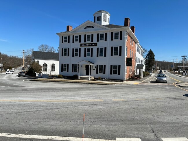
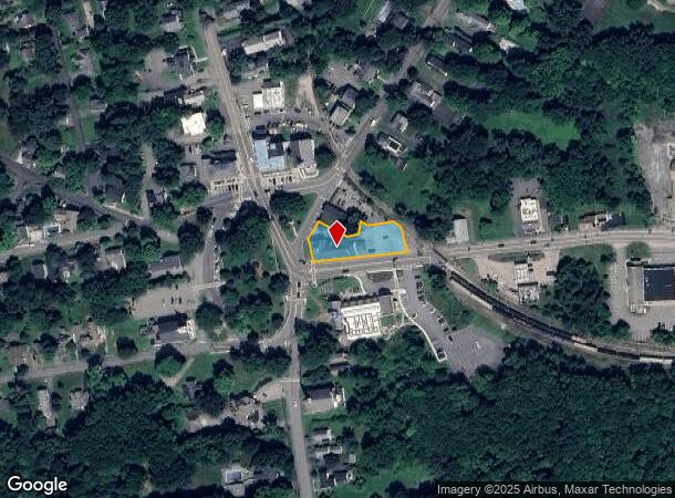


This Property Is For Sale
NEARBY LISTINGS FOR SALE OR LEASE
-
-
View all Grafton listings for sale on LoopNet.com
Property Detail
25 Grafton Cmn
GRAF-000074-000000-000800
Worcester
Resorthotel
Massachusetts
X
80.0
25027C0833E
0.53 AC
2025
Outlying Worcester
2025
Boston
738202
Worcester, MA-CT
12,770 SF
DEMOGRAPHICS near 25 Grafton Cmn
1 Mile
3 Mile
5 Mile
2024 Total Population
3,749
21,230
73,486
2029 Population
3,741
21,186
73,480
Pop Growth 2024-2029
(0.21%)
(0.21%)
(0.01%)
Average Age
42
41
41
2024 Total Households
1,497
8,096
28,241
HH Growth 2024-2029
(0.27%)
(0.23%)
(0.02%)
Median Household Inc
$109,595
$113,247
$113,735
Avg Household Size
2.50
2.60
2.60
2024 Avg HH Vehicles
2.00
2.00
2.00
Median Home Value
$466,181
$453,730
$441,910
Median Year Built
1978
1980
1979
Nearby Places
Map Layers
Map Styles
 Street
 Aerial
- Restaurants
- Banks
- Shops
- Fitness
- Groceries
PUBLIC TRANSPORTATION
COMMUTER RAIL
Grafton (Framingham/Worcester Line - Massachusetts Bay Transportation Authority Commuter Rail (Purple Line))
DRIVE
WALK
Distance
Grafton (Framingham/Worcester Line - Massachusetts Bay Transportation Authority Commuter Rail (Purple Line))
9 min
4.3 mi
Westborough (Framingham/Worcester Line - Massachusetts Bay Transportation Authority Commuter Rail (Purple Line))
DRIVE
WALK
Distance
Westborough (Framingham/Worcester Line - Massachusetts Bay Transportation Authority Commuter Rail (Purple Line))
16 min
5.9 mi
AIRPORT
Worcester Regional
DRIVE
WALK
Distance
Worcester Regional
26 min
15.0 mi
Freight Ports
Port of Boston
DRIVE
WALK
Distance
Port of Boston
62 min
44.6 mi
Nearby Properties
Address
Land Use
TOTAL SIZE
Lot Size
Zoning
Address
Land Use
TOTAL SIZE
Lot Size
Zoning
46.50 AC
R4
Address
Land Use
TOTAL SIZE
Lot Size
Zoning
375.66 AC
OLI
Address
Land Use
TOTAL SIZE
Lot Size
Zoning
55.79 AC
R4
Address
Land Use
TOTAL SIZE
Lot Size
Zoning
82,843 SF
15.70 AC
R4
Address
Land Use
TOTAL SIZE
Lot Size
Zoning
17.80 AC
R2
Address
Land Use
TOTAL SIZE
Lot Size
Zoning
57,288 SF
11.95 AC
CB
Address
Land Use
TOTAL SIZE
Lot Size
Zoning
12.50 AC
RMF
Address
Land Use
TOTAL SIZE
Lot Size
Zoning
43,542 SF
20.90 AC
R2
Address
Land Use
TOTAL SIZE
Lot Size
Zoning
9.29 AC
RMF
Address
Land Use
TOTAL SIZE
Lot Size
Zoning
10 AC
R2
Address
Land Use
TOTAL SIZE
Lot Size
Zoning
109,500 SF
7.40 AC
V
Address
Land Use
TOTAL SIZE
Lot Size
Zoning
32,573 SF
8.25 AC
R2
Address
Land Use
TOTAL SIZE
Lot Size
Zoning
2,228 SF
2.57 AC
R2
Address
Land Use
TOTAL SIZE
Lot Size
Zoning
30,624 SF
4.75 AC
OLI
Address
Land Use
TOTAL SIZE
Lot Size
Zoning
25,964 SF
0.60 AC
NB
Address
Land Use
TOTAL SIZE
Lot Size
Zoning
14,000 SF
104.37 AC
OLI
Address
Land Use
TOTAL SIZE
Lot Size
Zoning
77,251 SF
14.48 AC
OLI
Address
Land Use
TOTAL SIZE
Lot Size
Zoning
20,069 SF
224.29 AC
R4
Address
Land Use
TOTAL SIZE
Lot Size
Zoning
5.29 AC
CB
Address
Land Use
TOTAL SIZE
Lot Size
Zoning
13,500 SF
46.99 AC
R4
Address
Land Use
TOTAL SIZE
Lot Size
Zoning
10 AC
R2
Address
Land Use
TOTAL SIZE
Lot Size
Zoning
38.17 AC
R4
Address
Land Use
TOTAL SIZE
Lot Size
Zoning
96 AC
R2
Address
Land Use
TOTAL SIZE
Lot Size
Zoning
Address
Land Use
TOTAL SIZE
Lot Size
Zoning
26.17 AC
OLI
Address
Land Use
TOTAL SIZE
Lot Size
Zoning
17,652 SF
1.95 AC
Address
Land Use
TOTAL SIZE
Lot Size
Zoning
15,434 SF
3.39 AC
NB
Address
Land Use
TOTAL SIZE
Lot Size
Zoning
3.36 AC
RMF
Address
Land Use
TOTAL SIZE
Lot Size
Zoning
7.50 AC
R2
Address
Land Use
TOTAL SIZE
Lot Size
Zoning
14,382 SF
6.01 AC
OLI
The World's #1 Commercial Real Estate Marketplace
Connect with us
© 2025 CoStar Group
The information above has been obtained from sources believed reliable. While we do not doubt its accuracy we have not verified it and make no guarantee, warranty or representation about it. It is your responsibility to independently confirm its accuracy and completeness. Any projections, opinions, assumptions, or estimates used are for example only and do not represent the current or future performance of the property. The value of this transaction to you depends on tax and other factors which should be evaluated by your tax, financial, and legal advisors. You and your advisors should conduct a careful, independent investigation of the property to determine to your satisfaction the suitability of the property for your needs.