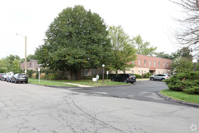
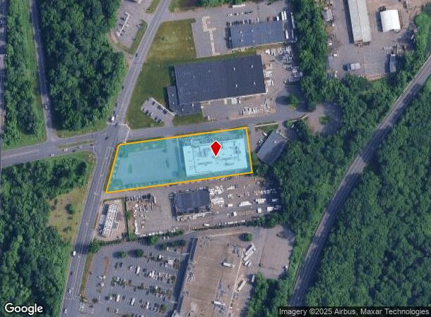
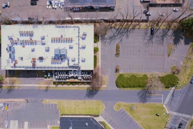
Property Record
25 Holly Dr, Newington, CT 06111

Current Lease Availabilities
NEARBY LISTINGS FOR SALE OR LEASE
Property Detail
25 Holly Dr
Warehouse
Hartford
X
Connecticut
09003C0484F
2.50 AC
2024
Newington
2025
Hartford
494600
Hartford-West Hartford-East Hartford, CT
61,428 SF
NEWI-000007-000004
DEMOGRAPHICS near 25 Holly Dr
1 Mile
3 Mile
5 Mile
2024 Total Population
7,055
94,733
229,916
2029 Population
7,053
93,893
227,326
Pop Growth 2024-2029
(0.03%)
(0.89%)
(1.13%)
Average Age
35
40
40
2024 Total Households
2,071
38,008
91,054
HH Growth 2024-2029
+ 0.39%
(0.90%)
(1.18%)
Median Household Inc
$76,141
$65,402
$72,455
Avg Household Size
2.20
2.30
2.40
2024 Avg HH Vehicles
2.00
2.00
2.00
Median Home Value
$238,319
$232,098
$257,852
Median Year Built
1965
1958
1956
Nearby Places
- Restaurants
- Banks
- Shops
- Fitness
- Groceries
PUBLIC TRANSPORTATION
COMMUTER RAIL
Berlin (Hartford Line - CONN DOT)
DRIVE
WALK
Distance
Berlin (Hartford Line - CONN DOT)
9 min
5.5 mi
Berlin Amtrak (Amtrak Hartford Line - Amtrak, Hartford Line - Amtrak, Northeast Regional - Amtrak, Valley Flyer - Amtrak)
DRIVE
WALK
Distance
Berlin Amtrak (Amtrak Hartford Line - Amtrak, Hartford Line - Amtrak, Northeast Regional - Amtrak, Valley Flyer - Amtrak)
9 min
5.5 mi
AIRPORT
Bradley International
DRIVE
WALK
Distance
Bradley International
44 min
26.0 mi
Freight Ports
Port of New Haven
DRIVE
WALK
Distance
Port of New Haven
45 min
33.6 mi
Nearby Properties
Address
Land Use
TOTAL SIZE
Lot Size
Zoning
Address
Land Use
TOTAL SIZE
Lot Size
Zoning
284,432 SF
32.12 AC
PL
Address
Land Use
TOTAL SIZE
Lot Size
Zoning
23.64 AC
S3
Address
Land Use
TOTAL SIZE
Lot Size
Zoning
261,072 SF
44.47 AC
PL
Address
Land Use
TOTAL SIZE
Lot Size
Zoning
54.95 AC
PDR
Address
Land Use
TOTAL SIZE
Lot Size
Zoning
20.61 AC
R-10,S
Address
Land Use
TOTAL SIZE
Lot Size
Zoning
131.09 AC
OP
Address
Land Use
TOTAL SIZE
Lot Size
Zoning
19.60 AC
S2
Address
Land Use
TOTAL SIZE
Lot Size
Zoning
2.07 AC
CBD
Address
Land Use
TOTAL SIZE
Lot Size
Zoning
23.62 AC
A3
Address
Land Use
TOTAL SIZE
Lot Size
Zoning
117,139 SF
6.77 AC
T
Address
Land Use
TOTAL SIZE
Lot Size
Zoning
90,625 SF
0.97 AC
CBD
Address
Land Use
TOTAL SIZE
Lot Size
Zoning
96,238 SF
6.75 AC
T
Address
Land Use
TOTAL SIZE
Lot Size
Zoning
14.68 AC
SIF
Address
Land Use
TOTAL SIZE
Lot Size
Zoning
2.46 AC
CBD
Address
Land Use
TOTAL SIZE
Lot Size
Zoning
162,470 SF
27.10 AC
R40
Address
Land Use
TOTAL SIZE
Lot Size
Zoning
78,109 SF
8.22 AC
T
Address
Land Use
TOTAL SIZE
Lot Size
Zoning
112,304 SF
10.39 AC
S3
Address
Land Use
TOTAL SIZE
Lot Size
Zoning
16.94 AC
C1
Address
Land Use
TOTAL SIZE
Lot Size
Zoning
215,215 SF
42 AC
R-10,R
Address
Land Use
TOTAL SIZE
Lot Size
Zoning
171,729 SF
80.59 AC
R-12/
Address
Land Use
TOTAL SIZE
Lot Size
Zoning
14,364 SF
2.72 AC
S3
Address
Land Use
TOTAL SIZE
Lot Size
Zoning
13.13 AC
SDD/BG
Address
Land Use
TOTAL SIZE
Lot Size
Zoning
111,532 SF
12.50 AC
R-12
Address
Land Use
TOTAL SIZE
Lot Size
Zoning
68 AC
R-20
Address
Land Use
TOTAL SIZE
Lot Size
Zoning
18.40 AC
PD
Address
Land Use
TOTAL SIZE
Lot Size
Zoning
78,132 SF
11.76 AC
S2
Address
Land Use
TOTAL SIZE
Lot Size
Zoning
83,464 SF
13.96 AC
T
Address
Land Use
TOTAL SIZE
Lot Size
Zoning
16.29 AC
PD
Address
Land Use
TOTAL SIZE
Lot Size
Zoning
121,775 SF
19.61 AC
PR
Address
Land Use
TOTAL SIZE
Lot Size
Zoning
53.52 AC
PL
The World's #1 Commercial Real Estate Marketplace
Connect with us
© 2025 CoStar Group
The information above has been obtained from sources believed reliable. While we do not doubt its accuracy we have not verified it and make no guarantee, warranty or representation about it. It is your responsibility to independently confirm its accuracy and completeness. Any projections, opinions, assumptions, or estimates used are for example only and do not represent the current or future performance of the property. The value of this transaction to you depends on tax and other factors which should be evaluated by your tax, financial, and legal advisors. You and your advisors should conduct a careful, independent investigation of the property to determine to your satisfaction the suitability of the property for your needs.