Property Record
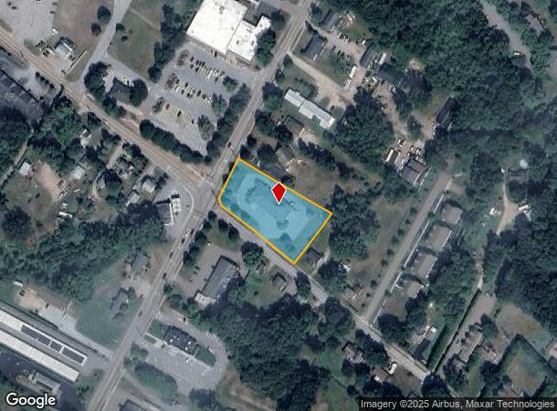
25 Macrae Rd, Colchester, VT 05446

NEARBY LISTINGS FOR SALE OR LEASE
Property Detail
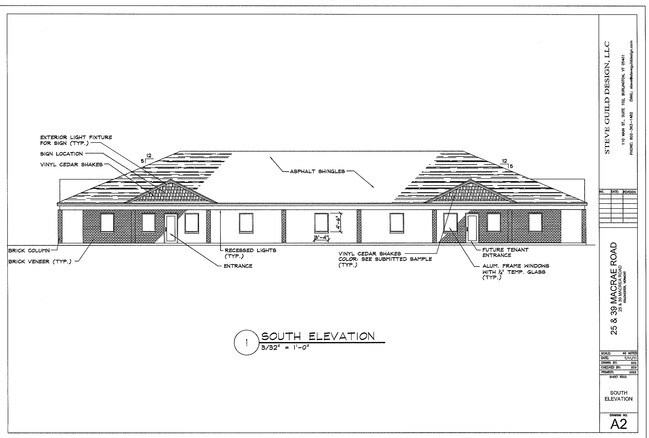
25 Macrae Rd
(048) 41-0970020000000
25 MACRAE RD
Departmentstore
Chittenden
X
Vermont
50007C0136D
2 AC
2024
Vermont North Area
2024
Other Market Areas
002303
Burlington-South Burlington, VT
6,095 SF
DEMOGRAPHICS near 25 Macrae Rd
1 Mile
3 Mile
5 Mile
2024 Total Population
2,678
18,310
54,022
2029 Population
2,705
18,590
54,736
Pop Growth 2024-2029
+ 1.01%
+ 1.53%
+ 1.32%
Average Age
42
43
38
2024 Total Households
1,100
7,619
23,538
HH Growth 2024-2029
+ 1.00%
+ 1.63%
+ 1.39%
Median Household Inc
$87,281
$89,337
$68,669
Avg Household Size
2.40
2.30
2.10
2024 Avg HH Vehicles
2.00
2.00
2.00
Median Home Value
$341,760
$365,311
$353,354
Median Year Built
1972
1973
1968
Nearby Places
Map Layers
Map Styles
 Street
 Aerial
- Restaurants
- Banks
- Shops
- Fitness
- Groceries
PUBLIC TRANSPORTATION
COMMUTER RAIL
Btn (Ethan Allen Express - Amtrak)
DRIVE
WALK
Distance
Btn (Ethan Allen Express - Amtrak)
10 min
5.2 mi
AIRPORT
Patrick Leahy Burlington International
DRIVE
WALK
Distance
Patrick Leahy Burlington International
25 min
9.5 mi
Plattsburgh International
DRIVE
WALK
Distance
Plattsburgh International
70 min
32.5 mi
Freight Ports
Montreal
DRIVE
WALK
Distance
Montreal
130 min
96.2 mi
SALE & LEASE HISTORY
LISTING DATE
SALE/LEASE

Feb 14, 2020
For Lease
Apr 20, 2021
For Lease
Nearby Properties
Address
Land Use
TOTAL SIZE
Lot Size
Zoning
Address
Land Use
TOTAL SIZE
Lot Size
Zoning
32.43 AC
I
Address
Land Use
TOTAL SIZE
Lot Size
Zoning
336,289 SF
25.93 AC
RL
Address
Land Use
TOTAL SIZE
Lot Size
Zoning
60,492 SF
RL
Address
Land Use
TOTAL SIZE
Lot Size
Zoning
77,700 SF
20.51 AC
RL
Address
Land Use
TOTAL SIZE
Lot Size
Zoning
38,378 SF
23.98 AC
RL
Address
Land Use
TOTAL SIZE
Lot Size
Zoning
79,640 SF
9.80 AC
RL
Address
Land Use
TOTAL SIZE
Lot Size
Zoning
47,822 SF
5.84 AC
RL
Address
Land Use
TOTAL SIZE
Lot Size
Zoning
49,948 SF
9.92 AC
RL
Address
Land Use
TOTAL SIZE
Lot Size
Zoning
30,766 SF
57.09 AC
RCO-C
Address
Land Use
TOTAL SIZE
Lot Size
Zoning
4.97 AC
RCOC
Address
Land Use
TOTAL SIZE
Lot Size
Zoning
42,678 SF
2.38 AC
NAC
Address
Land Use
TOTAL SIZE
Lot Size
Zoning
36,814 SF
NAC
Address
Land Use
TOTAL SIZE
Lot Size
Zoning
7.16 AC
NAC
Address
Land Use
TOTAL SIZE
Lot Size
Zoning
63,504 SF
RL
Address
Land Use
TOTAL SIZE
Lot Size
Zoning
48,126 SF
4 AC
NAC
Address
Land Use
TOTAL SIZE
Lot Size
Zoning
6.06 AC
RL
Address
Land Use
TOTAL SIZE
Lot Size
Zoning
3.84 AC
RL
Address
Land Use
TOTAL SIZE
Lot Size
Zoning
65.55 AC
RCO-RG
Address
Land Use
TOTAL SIZE
Lot Size
Zoning
28.07 AC
RL
Address
Land Use
TOTAL SIZE
Lot Size
Zoning
6,091 SF
87.11 AC
RCO-C
Address
Land Use
TOTAL SIZE
Lot Size
Zoning
85.60 AC
RCO-C
Address
Land Use
TOTAL SIZE
Lot Size
Zoning
37.79 AC
RCO-RG
Address
Land Use
TOTAL SIZE
Lot Size
Zoning
Address
Land Use
TOTAL SIZE
Lot Size
Zoning
1,346 SF
11.23 AC
RM
Address
Land Use
TOTAL SIZE
Lot Size
Zoning
3,982 SF
7.19 AC
RL
Address
Land Use
TOTAL SIZE
Lot Size
Zoning
6.22 AC
RL
Address
Land Use
TOTAL SIZE
Lot Size
Zoning
37,416 SF
1.05 AC
NAC
Address
Land Use
TOTAL SIZE
Lot Size
Zoning
21,237 SF
2.76 AC
RL
Address
Land Use
TOTAL SIZE
Lot Size
Zoning
18,048 SF
1.99 AC
RL
Address
Land Use
TOTAL SIZE
Lot Size
Zoning
11,244 SF
1.03 AC
NAC
The World's #1 Commercial Real Estate Marketplace
Connect with us
© 2025 CoStar Group
The information above has been obtained from sources believed reliable. While we do not doubt its accuracy we have not verified it and make no guarantee, warranty or representation about it. It is your responsibility to independently confirm its accuracy and completeness. Any projections, opinions, assumptions, or estimates used are for example only and do not represent the current or future performance of the property. The value of this transaction to you depends on tax and other factors which should be evaluated by your tax, financial, and legal advisors. You and your advisors should conduct a careful, independent investigation of the property to determine to your satisfaction the suitability of the property for your needs.