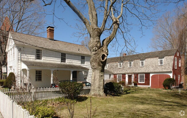
Property Record
25 Main St, Essex, CT 06426


NEARBY LISTINGS FOR SALE OR LEASE
Property Detail
25 Main St
Sfr
Middlesex
X
Connecticut
09011C0432G
0.21 AC
2025
SW Midlsx/Old Saybrk/Rt 9
2025
Hartford
630102
Hartford-West Hartford-East Hartford, CT
5,020 SF
ESSE-000047-000000-000066
DEMOGRAPHICS near 25 Main St
1 mile
3 mile
5 mile
2024 Total Population
1,847
9,186
26,127
2029 Population
1,864
9,172
26,134
Pop Growth 2024-2029
+ 0.92%
(0.15%)
+ 0.03%
Average Age
53
50
49
2024 Total Households
881
4,081
11,338
HH Growth 2024-2029
+ 0.79%
(0.25%)
(0.01%)
Median Household Inc
$121,452
$104,934
$98,938
Avg Household Size
2.00
2.20
2.20
2024 Avg HH Vehicles
2.00
2.00
2.00
Median Home Value
$617,231
$471,703
$404,750
Median Year Built
1961
1970
1969
Nearby Places
Map Layers
Map Styles
 Street
 Aerial
Transit
 Traffic
 Biking
Places
Listings with unknown addresses are not visible on the map
- Restaurants
- Banks
- Shops
- Fitness
- Groceries
PUBLIC TRANSPORTATION
COMMUTER RAIL
Old Saybrook (Shore Line East - Shore Line East)
Drive
Walk
Distance
Old Saybrook (Shore Line East - Shore Line East)
10 min
4.6 mi
Drive
Walk
Distance
12 min
6.0 mi
AIRPORT
Tweed/New Haven
Drive
Walk
Distance
Tweed/New Haven
43 min
29.8 mi
Nearby Properties
Address
Land Use
TOTAL SIZE
Lot Size
Zoning
Address
Land Use
TOTAL SIZE
Lot Size
Zoning
108.89 AC
RLC
Address
Land Use
TOTAL SIZE
Lot Size
Zoning
189,678 SF
44.72 AC
LI
Address
Land Use
TOTAL SIZE
Lot Size
Zoning
14.98 AC
VR
Address
Land Use
TOTAL SIZE
Lot Size
Zoning
24,360 SF
7.78 AC
B-2
Address
Land Use
TOTAL SIZE
Lot Size
Zoning
52,960 SF
32 AC
AA1
Address
Land Use
TOTAL SIZE
Lot Size
Zoning
8,533 SF
19.10 AC
Address
Land Use
TOTAL SIZE
Lot Size
Zoning
120,144 SF
17.10 AC
RLM
Address
Land Use
TOTAL SIZE
Lot Size
Zoning
13.80 AC
RU80
Address
Land Use
TOTAL SIZE
Lot Size
Zoning
5.10 AC
AA-3
Address
Land Use
TOTAL SIZE
Lot Size
Zoning
8,373 SF
2 AC
RU
Address
Land Use
TOTAL SIZE
Lot Size
Zoning
6,821 SF
2.80 AC
RU
Address
Land Use
TOTAL SIZE
Lot Size
Zoning
6,926 SF
4.41 AC
RRR
Address
Land Use
TOTAL SIZE
Lot Size
Zoning
9.10 AC
Address
Land Use
TOTAL SIZE
Lot Size
Zoning
7,866 SF
4.97 AC
AA-3
Address
Land Use
TOTAL SIZE
Lot Size
Zoning
5,071 SF
1.06 AC
RU
Address
Land Use
TOTAL SIZE
Lot Size
Zoning
5,713 SF
5.21 AC
RU80
Address
Land Use
TOTAL SIZE
Lot Size
Zoning
18,494 SF
10.40 AC
RU
Address
Land Use
TOTAL SIZE
Lot Size
Zoning
4.80 AC
MC
Address
Land Use
TOTAL SIZE
Lot Size
Zoning
18.80 AC
RU
Address
Land Use
TOTAL SIZE
Lot Size
Zoning
6,044 SF
6.21 AC
AA-3
Address
Land Use
TOTAL SIZE
Lot Size
Zoning
6,056 SF
8.37 AC
AA-3
Address
Land Use
TOTAL SIZE
Lot Size
Zoning
5,511 SF
3.92 AC
AA-3
Address
Land Use
TOTAL SIZE
Lot Size
Zoning
62.50 AC
RU
Address
Land Use
TOTAL SIZE
Lot Size
Zoning
19.60 AC
RU80
Address
Land Use
TOTAL SIZE
Lot Size
Zoning
5,142 SF
3.03 AC
RRR
Address
Land Use
TOTAL SIZE
Lot Size
Zoning
5,192 SF
0.91 AC
VR
Address
Land Use
TOTAL SIZE
Lot Size
Zoning
4.37 AC
RU80
Address
Land Use
TOTAL SIZE
Lot Size
Zoning
47.90 AC
RU80
Address
Land Use
TOTAL SIZE
Lot Size
Zoning
6,134 SF
17.47 AC
Address
Land Use
TOTAL SIZE
Lot Size
Zoning
22,500 SF
5.37 AC
B4
The World's #1 Commercial Real Estate Marketplace
Connect with us
© 2026 CoStar Group
The information above has been obtained from sources believed reliable. While we do not doubt its accuracy we have not verified it and make no guarantee, warranty or representation about it. It is your responsibility to independently confirm its accuracy and completeness. Any projections, opinions, assumptions, or estimates used are for example only and do not represent the current or future performance of the property. The value of this transaction to you depends on tax and other factors which should be evaluated by your tax, financial, and legal advisors. You and your advisors should conduct a careful, independent investigation of the property to determine to your satisfaction the suitability of the property for your needs.