Property Record
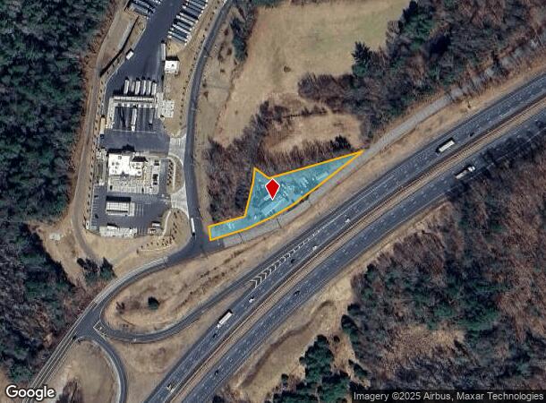
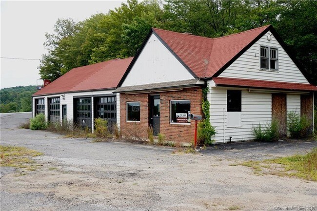
25 Mihaliak Rd, Willington, CT 06279

NEARBY LISTINGS FOR SALE OR LEASE
-
-
View all Willington listings for sale on LoopNet.com
Property Detail
25 Mihaliak Rd
Hartford-West Hartford-East Hartford, CT
Tolland
WILL-000000-000000-030100
Connecticut
Servicestation
20-0
2025
0.67 AC
2025
Tolland County
840100
Hartford
2,542 SF
DEMOGRAPHICS near 25 Mihaliak Rd
1 Mile
3 Mile
5 Mile
2024 Total Population
166
3,642
15,286
2029 Population
164
3,629
15,294
Pop Growth 2024-2029
(1.20%)
(0.36%)
+ 0.05%
Average Age
43
43
42
2024 Total Households
68
1,502
6,359
HH Growth 2024-2029
(1.47%)
(0.47%)
+ 0.05%
Median Household Inc
$99,999
$96,332
$81,528
Avg Household Size
2.40
2.40
2.40
2024 Avg HH Vehicles
2.00
2.00
2.00
Median Home Value
$262,499
$253,152
$262,712
Median Year Built
1968
1966
1969
Nearby Places
Map Layers
Map Styles
 Street
 Aerial
- Restaurants
- Banks
- Shops
- Fitness
- Groceries
PUBLIC TRANSPORTATION
AIRPORT
Bradley International
DRIVE
WALK
Distance
Bradley International
55 min
30.2 mi
Freight Ports
Port of Davisville, RI
DRIVE
WALK
Distance
Port of Davisville, RI
98 min
65.5 mi
SALE & LEASE HISTORY
LISTING DATE
SALE/LEASE

Nov 21, 2016
For Sale
Nearby Properties
Address
Land Use
TOTAL SIZE
Lot Size
Zoning
Address
Land Use
TOTAL SIZE
Lot Size
Zoning
247,817 SF
113.54 AC
DI
Address
Land Use
TOTAL SIZE
Lot Size
Zoning
14,433 SF
39.78 AC
DC
Address
Land Use
TOTAL SIZE
Lot Size
Zoning
14,562 SF
47.15 AC
DC
Address
Land Use
TOTAL SIZE
Lot Size
Zoning
31,016 SF
23 AC
R80
Address
Land Use
TOTAL SIZE
Lot Size
Zoning
462.80 AC
RDD
Address
Land Use
TOTAL SIZE
Lot Size
Zoning
10.60 AC
IN
Address
Land Use
TOTAL SIZE
Lot Size
Zoning
395.03 AC
DI
Address
Land Use
TOTAL SIZE
Lot Size
Zoning
73.60 AC
AAA
Address
Land Use
TOTAL SIZE
Lot Size
Zoning
221 AC
RDD
Address
Land Use
TOTAL SIZE
Lot Size
Zoning
18,394 SF
1.57 AC
DC
Address
Land Use
TOTAL SIZE
Lot Size
Zoning
8,013 SF
20.17 AC
DC
Address
Land Use
TOTAL SIZE
Lot Size
Zoning
6,300 SF
49.85 AC
R80
Address
Land Use
TOTAL SIZE
Lot Size
Zoning
81 AC
RDD
Address
Land Use
TOTAL SIZE
Lot Size
Zoning
6,411 SF
92.25 AC
DR
Address
Land Use
TOTAL SIZE
Lot Size
Zoning
7,679 SF
4.32 AC
RA60
Address
Land Use
TOTAL SIZE
Lot Size
Zoning
14,170 SF
0.28 AC
CB
Address
Land Use
TOTAL SIZE
Lot Size
Zoning
4.90 AC
A
Address
Land Use
TOTAL SIZE
Lot Size
Zoning
14,692 SF
3.11 AC
AA
Address
Land Use
TOTAL SIZE
Lot Size
Zoning
3.25 AC
DI
Address
Land Use
TOTAL SIZE
Lot Size
Zoning
4,266 SF
13.16 AC
R80
Address
Land Use
TOTAL SIZE
Lot Size
Zoning
3.77 AC
A
Address
Land Use
TOTAL SIZE
Lot Size
Zoning
70 AC
RDD
Address
Land Use
TOTAL SIZE
Lot Size
Zoning
130.05 AC
R80
Address
Land Use
TOTAL SIZE
Lot Size
Zoning
21.86 AC
DI
Address
Land Use
TOTAL SIZE
Lot Size
Zoning
1,860 SF
0.73 AC
DC
Address
Land Use
TOTAL SIZE
Lot Size
Zoning
5,814 SF
4.31 AC
DNC
Address
Land Use
TOTAL SIZE
Lot Size
Zoning
0.72 AC
CB
Address
Land Use
TOTAL SIZE
Lot Size
Zoning
1,485 SF
1.22 AC
R80
Address
Land Use
TOTAL SIZE
Lot Size
Zoning
6,000 SF
10 AC
B
Address
Land Use
TOTAL SIZE
Lot Size
Zoning
26,180 SF
21 AC
R80
The World's #1 Commercial Real Estate Marketplace
Connect with us
© 2026 CoStar Group
The information above has been obtained from sources believed reliable. While we do not doubt its accuracy we have not verified it and make no guarantee, warranty or representation about it. It is your responsibility to independently confirm its accuracy and completeness. Any projections, opinions, assumptions, or estimates used are for example only and do not represent the current or future performance of the property. The value of this transaction to you depends on tax and other factors which should be evaluated by your tax, financial, and legal advisors. You and your advisors should conduct a careful, independent investigation of the property to determine to your satisfaction the suitability of the property for your needs.