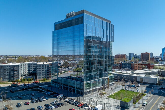
Property Record
225 N 38Th St, Philadelphia, PA 19104
Current Lease Availabilities
NEARBY LISTINGS FOR SALE OR LEASE
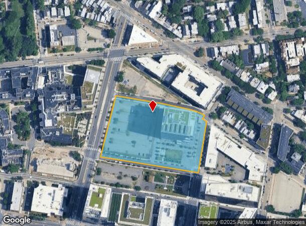
Property Detail
225 N 38Th St
885631800
200 OF SEC POWELTON
Parkingstructure
Philadelphia
X
Pennsylvania
42045C0150F
4.87 AC
2022
University City
2026
Philadelphia
009100
Philadelphia-Camden-Wilmington, PA-NJ-DE-MD
1 SF
DEMOGRAPHICS near 225 N 38Th St
1 Mile
3 Mile
5 Mile
2024 Total Population
59,157
547,256
994,667
2029 Population
58,343
535,527
975,500
Pop Growth 2024-2029
(1.38%)
(2.14%)
(1.93%)
Average Age
30
37
37
2024 Total Households
22,216
241,301
418,346
HH Growth 2024-2029
(1.76%)
(2.49%)
(2.19%)
Median Household Inc
$33,954
$55,276
$54,840
Avg Household Size
2.00
2.10
2.20
2024 Avg HH Vehicles
1.00
1.00
1.00
Median Home Value
$310,062
$280,654
$242,837
Median Year Built
1962
1948
1948
Nearby Places
Map Layers
Map Styles
 Street
 Aerial
- Restaurants
- Banks
- Shops
- Fitness
- Groceries
PUBLIC TRANSPORTATION
TRANSIT/SUBWAY
Lancaster Avenue And 38Th Street (Route 10 - Southeastern Pennsylvania Transportation Authority Rapid Transit (SEPTA Subway & Trolley))
DRIVE
WALK
Distance
Lancaster Avenue And 38Th Street (Route 10 - Southeastern Pennsylvania Transportation Authority Rapid Transit (SEPTA Subway & Trolley))
0 min
2 min
0.1 mi
Lancaster Ave & 36Th St (Route 10 - Southeastern Pennsylvania Transportation Authority Rapid Transit (SEPTA Subway & Trolley))
DRIVE
WALK
Distance
Lancaster Ave & 36Th St (Route 10 - Southeastern Pennsylvania Transportation Authority Rapid Transit (SEPTA Subway & Trolley))
1 min
4 min
0.3 mi
Lancaster Ave & Hamilton St (Route 10 - Southeastern Pennsylvania Transportation Authority Rapid Transit (SEPTA Subway & Trolley))
DRIVE
WALK
Distance
Lancaster Ave & Hamilton St (Route 10 - Southeastern Pennsylvania Transportation Authority Rapid Transit (SEPTA Subway & Trolley))
1 min
5 min
0.3 mi
40Th St & Filbert St (Route 10 - SEPTA)
DRIVE
WALK
Distance
40Th St & Filbert St (Route 10 - SEPTA)
1 min
7 min
0.4 mi
36Th Street (Market-Frankford Line - Southeastern Pennsylvania Transportation Authority Rapid Transit (SEPTA Subway & Trolley), Route 10 - Southeastern Pennsylvania Transportation Authority Rapid Transit (SEPTA Subway & Trolley))
DRIVE
WALK
Distance
36Th Street (Market-Frankford Line - Southeastern Pennsylvania Transportation Authority Rapid Transit (SEPTA Subway & Trolley), Route 10 - Southeastern Pennsylvania Transportation Authority Rapid Transit (SEPTA Subway & Trolley))
1 min
7 min
0.4 mi
COMMUTER RAIL
30Th St Lower Level (Airport Line - SEPTA, Wilmington/Newark Line - SEPTA)
DRIVE
WALK
Distance
30Th St Lower Level (Airport Line - SEPTA, Wilmington/Newark Line - SEPTA)
1 min
11 min
0.6 mi
Philadelphia 30Th Street (Atlantic City Line - NJ Transit Commuter Rail (NJ Transit), R1 - NJ Transit Commuter Rail (NJ Transit), R2 - NJ Transit Commuter Rail (NJ Transit), R3 - NJ Transit Commuter Rail (NJ Transit), R5 - NJ Transit Commuter Rail (NJ Transit), R6 - NJ Transit Commuter Rail (NJ Transit), R7 - NJ Transit Commuter Rail (NJ Transit), R8 - NJ Transit Commuter Rail (NJ Transit))
DRIVE
WALK
Distance
Philadelphia 30Th Street (Atlantic City Line - NJ Transit Commuter Rail (NJ Transit), R1 - NJ Transit Commuter Rail (NJ Transit), R2 - NJ Transit Commuter Rail (NJ Transit), R3 - NJ Transit Commuter Rail (NJ Transit), R5 - NJ Transit Commuter Rail (NJ Transit), R6 - NJ Transit Commuter Rail (NJ Transit), R7 - NJ Transit Commuter Rail (NJ Transit), R8 - NJ Transit Commuter Rail (NJ Transit))
4 min
20 min
1.0 mi
AIRPORT
Philadelphia International
DRIVE
WALK
Distance
Philadelphia International
20 min
9.3 mi
Trenton Mercer
DRIVE
WALK
Distance
Trenton Mercer
52 min
35.6 mi
Freight Ports
South Jersey Port
DRIVE
WALK
Distance
South Jersey Port
13 min
6.3 mi
Nearby Properties
Address
Land Use
TOTAL SIZE
Lot Size
Zoning
Address
Land Use
TOTAL SIZE
Lot Size
Zoning
1,449,928 SF
1.22 AC
CMX5
Address
Land Use
TOTAL SIZE
Lot Size
Zoning
1,076,400 SF
5 AC
CMX4
Address
Land Use
TOTAL SIZE
Lot Size
Zoning
1,200,021 SF
0.69 AC
CMX5
Address
Land Use
TOTAL SIZE
Lot Size
Zoning
26,690 SF
500 AC
SPINS
Address
Land Use
TOTAL SIZE
Lot Size
Zoning
1,103,300 SF
1.18 AC
CMX5
Address
Land Use
TOTAL SIZE
Lot Size
Zoning
1,464,000 SF
0.76 AC
CMX5
Address
Land Use
TOTAL SIZE
Lot Size
Zoning
319,590 SF
0.87 AC
I2
Address
Land Use
TOTAL SIZE
Lot Size
Zoning
760,635 SF
0.77 AC
CMX5
Address
Land Use
TOTAL SIZE
Lot Size
Zoning
1,179,072 SF
8.90 AC
RM4
Address
Land Use
TOTAL SIZE
Lot Size
Zoning
1,296,804 SF
2.71 AC
I2
Address
Land Use
TOTAL SIZE
Lot Size
Zoning
782,208 SF
0.68 AC
CMX5
Address
Land Use
TOTAL SIZE
Lot Size
Zoning
2,215,276 SF
2.46 AC
CMX5
Address
Land Use
TOTAL SIZE
Lot Size
Zoning
624,696 SF
5.79 AC
CMX4
Address
Land Use
TOTAL SIZE
Lot Size
Zoning
1,200,000 SF
1.78 AC
CMX5
Address
Land Use
TOTAL SIZE
Lot Size
Zoning
1,075,580 SF
2.65 AC
CMX5
Address
Land Use
TOTAL SIZE
Lot Size
Zoning
468,307 SF
2.45 AC
CMX4
Address
Land Use
TOTAL SIZE
Lot Size
Zoning
500,165 SF
2.16 AC
SPPOA
Address
Land Use
TOTAL SIZE
Lot Size
Zoning
1,152,520 SF
1.49 AC
CMX5
Address
Land Use
TOTAL SIZE
Lot Size
Zoning
696,920 SF
10.55 AC
SPINS
Address
Land Use
TOTAL SIZE
Lot Size
Zoning
1,143,040 SF
0.81 AC
CMX5
Address
Land Use
TOTAL SIZE
Lot Size
Zoning
738,750 SF
1.19 AC
CMX5
Address
Land Use
TOTAL SIZE
Lot Size
Zoning
700,000 SF
7.88 AC
CMX5
Address
Land Use
TOTAL SIZE
Lot Size
Zoning
1,102,992 SF
2.14 AC
CMX5
Address
Land Use
TOTAL SIZE
Lot Size
Zoning
1.88 AC
SPINS
Address
Land Use
TOTAL SIZE
Lot Size
Zoning
738,207 SF
0.89 AC
CMX5
Address
Land Use
TOTAL SIZE
Lot Size
Zoning
665,742 SF
0.98 AC
CMX4
Address
Land Use
TOTAL SIZE
Lot Size
Zoning
1,152,480 SF
1.48 AC
CMX5
Address
Land Use
TOTAL SIZE
Lot Size
Zoning
1,011,079 SF
5.82 AC
CMX5
Address
Land Use
TOTAL SIZE
Lot Size
Zoning
677,140 SF
0.53 AC
CMX5
Address
Land Use
TOTAL SIZE
Lot Size
Zoning
728,244 SF
5.56 AC
CMX4
The World's #1 Commercial Real Estate Marketplace
Connect with us
© 2026 CoStar Group
The information above has been obtained from sources believed reliable. While we do not doubt its accuracy we have not verified it and make no guarantee, warranty or representation about it. It is your responsibility to independently confirm its accuracy and completeness. Any projections, opinions, assumptions, or estimates used are for example only and do not represent the current or future performance of the property. The value of this transaction to you depends on tax and other factors which should be evaluated by your tax, financial, and legal advisors. You and your advisors should conduct a careful, independent investigation of the property to determine to your satisfaction the suitability of the property for your needs.