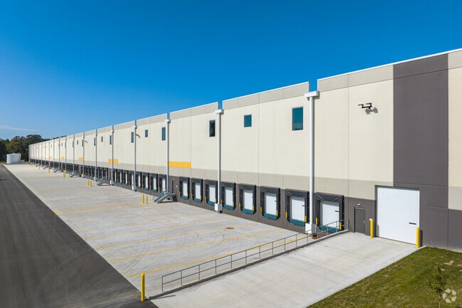
Property Record
25 N Golfwood Ave, Penns Grove, NJ 08069


NEARBY LISTINGS FOR SALE OR LEASE
-
-
896-900 Courses Landing Rd, Penns Grove
Carneys Point, NJ 08069
Rent Upon Request
11,000 SF
Industrial
-
-
-
-
-
-
View all Penns Grove listings for lease on LoopNet.com
Property Detail
25 N Golfwood Ave
02 00055-0000-00014-0000-QFARM
Salem
Industrialgeneral
New Jersey
X
14
34033C0054C
29.05 AC
2024
Salem County
2025
Philadelphia
020600
Philadelphia-Camden-Wilmington, PA-NJ-DE-MD
DEMOGRAPHICS near 25 N Golfwood Ave
1 Mile
3 Mile
5 Mile
2024 Total Population
1,476
14,913
33,221
2029 Population
1,488
15,190
33,723
Pop Growth 2024-2029
+ 0.81%
+ 1.86%
+ 1.51%
Average Age
44
40
41
2024 Total Households
597
5,586
13,357
HH Growth 2024-2029
+ 0.84%
+ 1.79%
+ 1.44%
Median Household Inc
$68,589
$59,777
$68,523
Avg Household Size
2.40
2.60
2.40
2024 Avg HH Vehicles
2.00
2.00
2.00
Median Home Value
$167,167
$164,273
$195,807
Median Year Built
1964
1958
1958
Nearby Places
Map Layers
Map Styles
 Street
 Aerial
- Restaurants
- Banks
- Shops
- Fitness
- Groceries
PUBLIC TRANSPORTATION
AIRPORT
Philadelphia International
DRIVE
WALK
Distance
Philadelphia International
33 min
22.4 mi
Freight Ports
Port of Wilmington, RI
DRIVE
WALK
Distance
Port of Wilmington, RI
19 min
10.3 mi
SALE & LEASE HISTORY
LISTING DATE
SALE/LEASE

Feb 09, 2022
For Lease
Nearby Properties
Address
Land Use
TOTAL SIZE
Lot Size
Zoning
Address
Land Use
TOTAL SIZE
Lot Size
Zoning
118.77 AC
GC
Address
Land Use
TOTAL SIZE
Lot Size
Zoning
150.60 AC
AG
Address
Land Use
TOTAL SIZE
Lot Size
Zoning
47.91 AC
IC
Address
Land Use
TOTAL SIZE
Lot Size
Zoning
Address
Land Use
TOTAL SIZE
Lot Size
Zoning
41.27 AC
GC
Address
Land Use
TOTAL SIZE
Lot Size
Zoning
10.75 AC
LC
Address
Land Use
TOTAL SIZE
Lot Size
Zoning
45.23 AC
Address
Land Use
TOTAL SIZE
Lot Size
Zoning
118.77 AC
GC
Address
Land Use
TOTAL SIZE
Lot Size
Zoning
29.05 AC
GC
Address
Land Use
TOTAL SIZE
Lot Size
Zoning
23,402 SF
44.89 AC
LR
Address
Land Use
TOTAL SIZE
Lot Size
Zoning
68.75 AC
Address
Land Use
TOTAL SIZE
Lot Size
Zoning
59.78 AC
Address
Land Use
TOTAL SIZE
Lot Size
Zoning
26.64 AC
GI
Address
Land Use
TOTAL SIZE
Lot Size
Zoning
21.39 AC
Address
Land Use
TOTAL SIZE
Lot Size
Zoning
150.60 AC
AG
Address
Land Use
TOTAL SIZE
Lot Size
Zoning
47.91 AC
IC
Address
Land Use
TOTAL SIZE
Lot Size
Zoning
16.96 AC
Address
Land Use
TOTAL SIZE
Lot Size
Zoning
20 AC
GI
Address
Land Use
TOTAL SIZE
Lot Size
Zoning
30.10 AC
Address
Land Use
TOTAL SIZE
Lot Size
Zoning
10.28 AC
IC
Address
Land Use
TOTAL SIZE
Lot Size
Zoning
41.27 AC
GC
Address
Land Use
TOTAL SIZE
Lot Size
Zoning
848 SF
10.69 AC
LR
Address
Land Use
TOTAL SIZE
Lot Size
Zoning
22.39 AC
Address
Land Use
TOTAL SIZE
Lot Size
Zoning
1,133.55 AC
GI
Address
Land Use
TOTAL SIZE
Lot Size
Zoning
19.67 AC
LR
Address
Land Use
TOTAL SIZE
Lot Size
Zoning
11.76 AC
GC
Address
Land Use
TOTAL SIZE
Lot Size
Zoning
204.56 AC
GI
Address
Land Use
TOTAL SIZE
Lot Size
Zoning
16.80 AC
Address
Land Use
TOTAL SIZE
Lot Size
Zoning
The World's #1 Commercial Real Estate Marketplace
Connect with us
© 2025 CoStar Group
The information above has been obtained from sources believed reliable. While we do not doubt its accuracy we have not verified it and make no guarantee, warranty or representation about it. It is your responsibility to independently confirm its accuracy and completeness. Any projections, opinions, assumptions, or estimates used are for example only and do not represent the current or future performance of the property. The value of this transaction to you depends on tax and other factors which should be evaluated by your tax, financial, and legal advisors. You and your advisors should conduct a careful, independent investigation of the property to determine to your satisfaction the suitability of the property for your needs.