Property Record
25 N Us Highway 89 St, Alpine, WY 83128


NEARBY LISTINGS FOR SALE OR LEASE
-
-
View all Alpine listings for sale on LoopNet.com
Property Detail
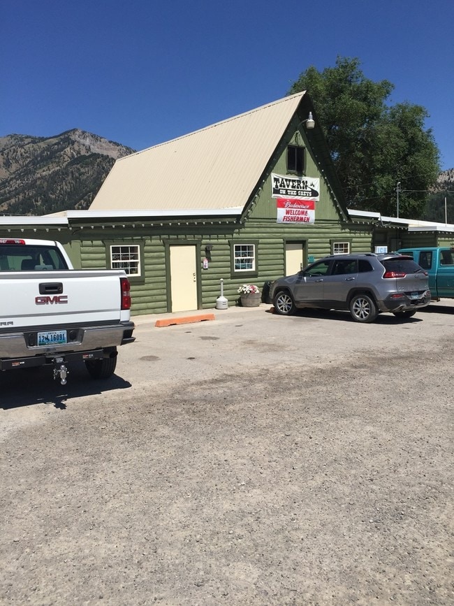
25 N Us Highway 89 St
3718-291-01-008.00
Palis Park
Bartavern
PALIS PARK TR 01A 02A TOTAL 6.09 ACRES T37 R118 S29
X
Lincoln
56023C0145D
Wyoming
2024
6.09 AC
2025
Wyoming Area
978002
Other Market Areas
3,354 SF
DEMOGRAPHICS near 25 N Us Highway 89 St
1 Mile
3 Mile
5 Mile
2024 Total Population
727
829
1,083
2029 Population
830
946
1,234
Pop Growth 2024-2029
+ 14.17%
+ 14.11%
+ 13.94%
Average Age
41
41
41
2024 Total Households
300
342
446
HH Growth 2024-2029
+ 13.67%
+ 13.74%
+ 13.45%
Median Household Inc
$76,013
$77,778
$79,281
Avg Household Size
2.40
2.40
2.40
2024 Avg HH Vehicles
3.00
3.00
3.00
Median Home Value
$345,945
$348,800
$361,437
Median Year Built
1980
1981
1986
Nearby Places
Map Layers
Map Styles
 Street
 Aerial
- Restaurants
- Banks
- Shops
- Fitness
- Groceries
PUBLIC TRANSPORTATION
AIRPORT
Jackson Hole
DRIVE
WALK
Distance
Jackson Hole
68 min
46.3 mi
SALE & LEASE HISTORY
LISTING DATE
SALE/LEASE

Sep 23, 2016
For Sale
Oct 20, 2016
For Sale
Nearby Properties
Address
Land Use
TOTAL SIZE
Lot Size
Zoning
Address
Land Use
TOTAL SIZE
Lot Size
Zoning
42,380 SF
5.06 AC
Address
Land Use
TOTAL SIZE
Lot Size
Zoning
6,600 SF
9.12 AC
Address
Land Use
TOTAL SIZE
Lot Size
Zoning
37,962 SF
2.30 AC
Address
Land Use
TOTAL SIZE
Lot Size
Zoning
9,907 SF
6.35 AC
Address
Land Use
TOTAL SIZE
Lot Size
Zoning
5,050 SF
19.12 AC
Address
Land Use
TOTAL SIZE
Lot Size
Zoning
35,772 SF
0.73 AC
Address
Land Use
TOTAL SIZE
Lot Size
Zoning
18,832 SF
9.70 AC
Address
Land Use
TOTAL SIZE
Lot Size
Zoning
5,309 SF
1.09 AC
Address
Land Use
TOTAL SIZE
Lot Size
Zoning
18,600 SF
6.18 AC
Address
Land Use
TOTAL SIZE
Lot Size
Zoning
7,134 SF
1.79 AC
Address
Land Use
TOTAL SIZE
Lot Size
Zoning
27,696 SF
1.92 AC
Address
Land Use
TOTAL SIZE
Lot Size
Zoning
19.31 AC
Address
Land Use
TOTAL SIZE
Lot Size
Zoning
14,596 SF
2.24 AC
Address
Land Use
TOTAL SIZE
Lot Size
Zoning
Address
Land Use
TOTAL SIZE
Lot Size
Zoning
10,240 SF
1.10 AC
Address
Land Use
TOTAL SIZE
Lot Size
Zoning
Address
Land Use
TOTAL SIZE
Lot Size
Zoning
12,634 SF
1.05 AC
Address
Land Use
TOTAL SIZE
Lot Size
Zoning
5,040 SF
5.78 AC
Address
Land Use
TOTAL SIZE
Lot Size
Zoning
5,000 SF
5 AC
Address
Land Use
TOTAL SIZE
Lot Size
Zoning
840 SF
11.84 AC
Address
Land Use
TOTAL SIZE
Lot Size
Zoning
16,524 SF
5.63 AC
Address
Land Use
TOTAL SIZE
Lot Size
Zoning
4,800 SF
0.93 AC
Address
Land Use
TOTAL SIZE
Lot Size
Zoning
3,264 SF
0.89 AC
Address
Land Use
TOTAL SIZE
Lot Size
Zoning
7,120 SF
1.31 AC
Address
Land Use
TOTAL SIZE
Lot Size
Zoning
2.28 AC
Address
Land Use
TOTAL SIZE
Lot Size
Zoning
8,704 SF
0.36 AC
Address
Land Use
TOTAL SIZE
Lot Size
Zoning
8,122 SF
1.05 AC
Address
Land Use
TOTAL SIZE
Lot Size
Zoning
18,000 SF
1.32 AC
Address
Land Use
TOTAL SIZE
Lot Size
Zoning
8,045 SF
0.34 AC
The World's #1 Commercial Real Estate Marketplace
Connect with us
© 2026 CoStar Group
The information above has been obtained from sources believed reliable. While we do not doubt its accuracy we have not verified it and make no guarantee, warranty or representation about it. It is your responsibility to independently confirm its accuracy and completeness. Any projections, opinions, assumptions, or estimates used are for example only and do not represent the current or future performance of the property. The value of this transaction to you depends on tax and other factors which should be evaluated by your tax, financial, and legal advisors. You and your advisors should conduct a careful, independent investigation of the property to determine to your satisfaction the suitability of the property for your needs.