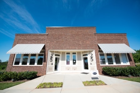
Property Record
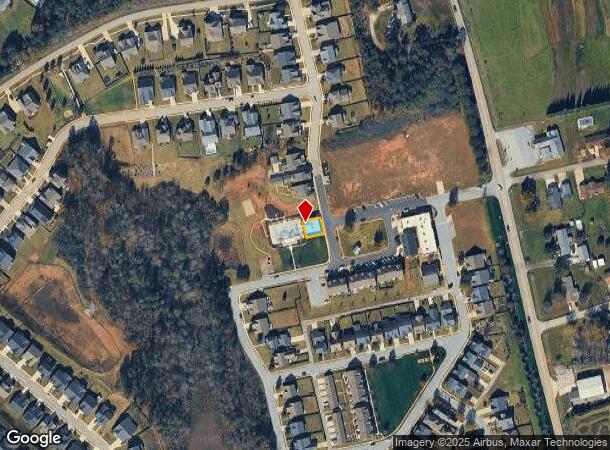
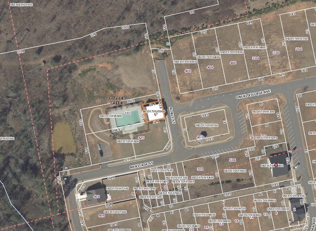
25 Noble St, Greer, SC 29651
NEARBY LISTINGS FOR SALE OR LEASE
Property Detail
25 Noble St
Greenville-Anderson-Greer, SC
Oneal Village
0633.17-01-059.00
LOT A PH 1-C
Storebuilding
Greenville
X
South Carolina
45045C0332F
a
2025
0.07 AC
2024
Travelers Rest
002405
Greenville/Spartanburg
DEMOGRAPHICS near 25 Noble St
1 mile
3 mile
5 mile
2024 Total Population
3,196
18,947
53,345
2029 Population
3,584
20,996
59,221
Pop Growth 2024-2029
+ 12.14%
+ 10.81%
+ 11.02%
Average Age
39
41
41
2024 Total Households
1,198
7,137
20,983
HH Growth 2024-2029
+ 12.19%
+ 10.87%
+ 11.10%
Median Household Inc
$98,776
$84,639
$68,115
Avg Household Size
2.70
2.60
2.50
2024 Avg HH Vehicles
2.00
2.00
2.00
Median Home Value
$271,586
$260,131
$241,846
Median Year Built
2008
2002
1996
Nearby Places
Map Layers
Map Styles
 Street
 Aerial
Transit
 Traffic
 Biking
Places
Listings with unknown addresses are not visible on the map
- Restaurants
- Banks
- Shops
- Fitness
- Groceries
PUBLIC TRANSPORTATION
AIRPORT
Greenville Spartanburg International
Drive
Walk
Distance
Greenville Spartanburg International
16 min
8.6 mi
Asheville Regional
Drive
Walk
Distance
Asheville Regional
64 min
45.8 mi
Nearby Properties
Address
Land Use
TOTAL SIZE
Lot Size
Zoning
Address
Land Use
TOTAL SIZE
Lot Size
Zoning
3,649 SF
16.04 AC
UNZONED
Address
Land Use
TOTAL SIZE
Lot Size
Zoning
83.58 AC
RS
Address
Land Use
TOTAL SIZE
Lot Size
Zoning
82.10 AC
S1
Address
Land Use
TOTAL SIZE
Lot Size
Zoning
74.10 AC
RS
Address
Land Use
TOTAL SIZE
Lot Size
Zoning
70.66 AC
RS
Address
Land Use
TOTAL SIZE
Lot Size
Zoning
71.11 AC
RS
Address
Land Use
TOTAL SIZE
Lot Size
Zoning
2,341 SF
59.60 AC
PDR
Address
Land Use
TOTAL SIZE
Lot Size
Zoning
60.30 AC
RS
Address
Land Use
TOTAL SIZE
Lot Size
Zoning
76.50 AC
RS
Address
Land Use
TOTAL SIZE
Lot Size
Zoning
58.18 AC
UNZONED
Address
Land Use
TOTAL SIZE
Lot Size
Zoning
33.77 AC
UNZONED
Address
Land Use
TOTAL SIZE
Lot Size
Zoning
1,390 SF
4.50 AC
UNZONED
Address
Land Use
TOTAL SIZE
Lot Size
Zoning
2,323 SF
0.46 AC
Address
Land Use
TOTAL SIZE
Lot Size
Zoning
5.29 AC
UNZONED
Address
Land Use
TOTAL SIZE
Lot Size
Zoning
3,013 SF
0.77 AC
UNZONED
Address
Land Use
TOTAL SIZE
Lot Size
Zoning
720 SF
22.40 AC
RS
Address
Land Use
TOTAL SIZE
Lot Size
Zoning
22.10 AC
RS
Address
Land Use
TOTAL SIZE
Lot Size
Zoning
21.14 AC
RS
Address
Land Use
TOTAL SIZE
Lot Size
Zoning
2,102 SF
0.48 AC
UNZONED
Address
Land Use
TOTAL SIZE
Lot Size
Zoning
5.70 AC
UNZONED
Address
Land Use
TOTAL SIZE
Lot Size
Zoning
2,289 SF
0.94 AC
RS
Address
Land Use
TOTAL SIZE
Lot Size
Zoning
952 SF
14.28 AC
RS
Address
Land Use
TOTAL SIZE
Lot Size
Zoning
34.14 AC
AG-20
Address
Land Use
TOTAL SIZE
Lot Size
Zoning
2,081 SF
0.28 AC
UNZONED
Address
Land Use
TOTAL SIZE
Lot Size
Zoning
1,440 SF
7.32 AC
UNZONED
Address
Land Use
TOTAL SIZE
Lot Size
Zoning
1,971 SF
0.24 AC
R5
Address
Land Use
TOTAL SIZE
Lot Size
Zoning
2,213 SF
1.20 AC
RS
Address
Land Use
TOTAL SIZE
Lot Size
Zoning
13.86 AC
UNZONED
Address
Land Use
TOTAL SIZE
Lot Size
Zoning
2,064 SF
0.51 AC
UNZONED
Address
Land Use
TOTAL SIZE
Lot Size
Zoning
2,086 SF
0.50 AC
UNZONED
The World's #1 Commercial Real Estate Marketplace
Connect with us
© 2026 CoStar Group
The information above has been obtained from sources believed reliable. While we do not doubt its accuracy we have not verified it and make no guarantee, warranty or representation about it. It is your responsibility to independently confirm its accuracy and completeness. Any projections, opinions, assumptions, or estimates used are for example only and do not represent the current or future performance of the property. The value of this transaction to you depends on tax and other factors which should be evaluated by your tax, financial, and legal advisors. You and your advisors should conduct a careful, independent investigation of the property to determine to your satisfaction the suitability of the property for your needs.