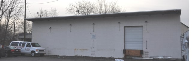
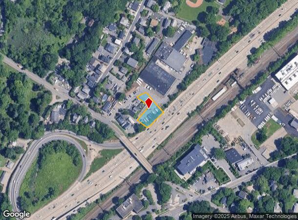
Property Record
25 Nursery Ln, Rye, NY 10580
NEARBY LISTINGS FOR SALE OR LEASE
Property Detail
25 Nursery Ln
New York-Jersey City-White Plains, NY-NJ
Survey & Subdivision Property Joseph Ant
1400-146-010-00001-000-0053
Westchester
Truckterminal
New York
X
53.000
36119C0352F
0.40 AC
2025
East I-287 Corridor
2024
Westchester/So Connecticut
007700
DEMOGRAPHICS near 25 Nursery Ln
1 Mile
3 Mile
5 Mile
2024 Total Population
11,284
79,503
173,245
2029 Population
11,137
76,749
169,487
Pop Growth 2024-2029
(1.30%)
(3.46%)
(2.17%)
Average Age
41
40
41
2024 Total Households
4,041
27,607
60,862
HH Growth 2024-2029
(1.31%)
(3.55%)
(2.24%)
Median Household Inc
$174,480
$132,276
$148,185
Avg Household Size
2.70
2.80
2.70
2024 Avg HH Vehicles
2.00
2.00
2.00
Median Home Value
$1,063,238
$851,598
$871,067
Median Year Built
1959
1957
1956
Nearby Places
- Restaurants
- Banks
- Shops
- Fitness
- Groceries
PUBLIC TRANSPORTATION
COMMUTER RAIL
Rye Station (New Haven Line - Metro-North Commuter Railroad Company (Metro-North))
DRIVE
WALK
Distance
Rye Station (New Haven Line - Metro-North Commuter Railroad Company (Metro-North))
3 min
1.2 mi
Harrison Station (New Haven Line - Metro-North Commuter Railroad Company (Metro-North))
DRIVE
WALK
Distance
Harrison Station (New Haven Line - Metro-North Commuter Railroad Company (Metro-North))
4 min
1.3 mi
AIRPORT
Westchester County
DRIVE
WALK
Distance
Westchester County
16 min
9.6 mi
LaGuardia
DRIVE
WALK
Distance
LaGuardia
38 min
22.9 mi
John F Kennedy International
DRIVE
WALK
Distance
John F Kennedy International
44 min
30.4 mi
Freight Ports
NY - Red Hook Container Terminal
DRIVE
WALK
Distance
NY - Red Hook Container Terminal
52 min
33.4 mi
Nearby Properties
Address
Land Use
TOTAL SIZE
Lot Size
Zoning
Address
Land Use
TOTAL SIZE
Lot Size
Zoning
5COMMUND
Address
Land Use
TOTAL SIZE
Lot Size
Zoning
Address
Land Use
TOTAL SIZE
Lot Size
Zoning
277,172 SF
29.98 AC
CD COMM
Address
Land Use
TOTAL SIZE
Lot Size
Zoning
0.01 AC
5COMMUND
Address
Land Use
TOTAL SIZE
Lot Size
Zoning
5COMMUND
Address
Land Use
TOTAL SIZE
Lot Size
Zoning
345,927 SF
4.32 AC
MUR WTRFR
Address
Land Use
TOTAL SIZE
Lot Size
Zoning
556,297 SF
25.31 AC
05 - COMME
Address
Land Use
TOTAL SIZE
Lot Size
Zoning
125,010 SF
4.02 AC
Address
Land Use
TOTAL SIZE
Lot Size
Zoning
5COMMUND
Address
Land Use
TOTAL SIZE
Lot Size
Zoning
21.33 AC
Address
Land Use
TOTAL SIZE
Lot Size
Zoning
135,380 SF
7.32 AC
MUR WTRFR
Address
Land Use
TOTAL SIZE
Lot Size
Zoning
143,372 SF
24.05 AC
OB-2 OFFC
Address
Land Use
TOTAL SIZE
Lot Size
Zoning
84,747 SF
8.64 AC
C1-P RTAIL
Address
Land Use
TOTAL SIZE
Lot Size
Zoning
188.31 AC
Address
Land Use
TOTAL SIZE
Lot Size
Zoning
67.51 AC
Address
Land Use
TOTAL SIZE
Lot Size
Zoning
9.30 AC
M2 INDUST
Address
Land Use
TOTAL SIZE
Lot Size
Zoning
1,056 SF
42.50 AC
PB
Address
Land Use
TOTAL SIZE
Lot Size
Zoning
5COMMUND
Address
Land Use
TOTAL SIZE
Lot Size
Zoning
5.57 AC
AA1
Address
Land Use
TOTAL SIZE
Lot Size
Zoning
122,386 SF
1.39 AC
DW2 WTRFR
Address
Land Use
TOTAL SIZE
Lot Size
Zoning
65,659 SF
7.72 AC
R-6
Address
Land Use
TOTAL SIZE
Lot Size
Zoning
101,657 SF
1.14 AC
C2 COMM
Address
Land Use
TOTAL SIZE
Lot Size
Zoning
171,925 SF
6.21 AC
M2 INDUST
Address
Land Use
TOTAL SIZE
Lot Size
Zoning
6.31 AC
R-5 SFR
Address
Land Use
TOTAL SIZE
Lot Size
Zoning
37,187 SF
2.62 AC
Address
Land Use
TOTAL SIZE
Lot Size
Zoning
75,598 SF
0.54 AC
MUR WTRFR
Address
Land Use
TOTAL SIZE
Lot Size
Zoning
10.10 AC
RA-1
Address
Land Use
TOTAL SIZE
Lot Size
Zoning
109,212 SF
1.80 AC
CD COMM
Address
Land Use
TOTAL SIZE
Lot Size
Zoning
123,454 SF
1.54 AC
M2 INDUST
Address
Land Use
TOTAL SIZE
Lot Size
Zoning
68,022 SF
4.31 AC
The World's #1 Commercial Real Estate Marketplace
Connect with us
© 2025 CoStar Group
The information above has been obtained from sources believed reliable. While we do not doubt its accuracy we have not verified it and make no guarantee, warranty or representation about it. It is your responsibility to independently confirm its accuracy and completeness. Any projections, opinions, assumptions, or estimates used are for example only and do not represent the current or future performance of the property. The value of this transaction to you depends on tax and other factors which should be evaluated by your tax, financial, and legal advisors. You and your advisors should conduct a careful, independent investigation of the property to determine to your satisfaction the suitability of the property for your needs.