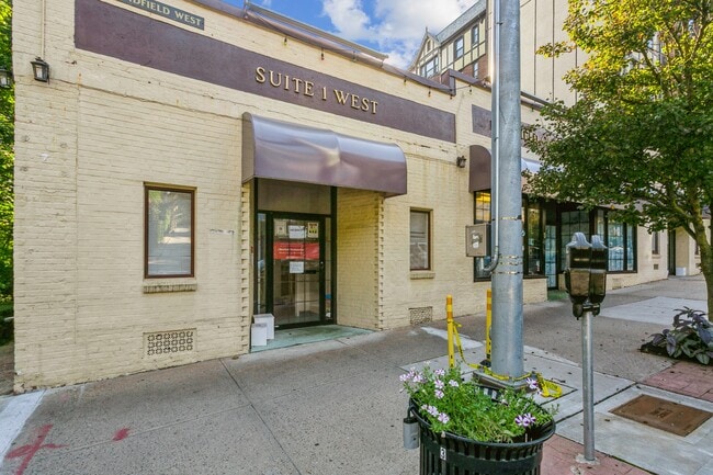
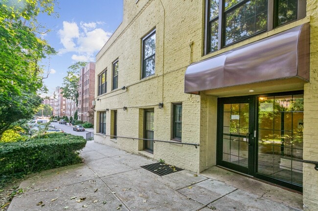
Property Record
25 Pondfield Rd W, Bronxville, NY 10708

Save to a Folder
{{folder.Name}}
{{folder.ListingIds.length}} Properties
{{folder.ListingIds.length}} Property
Create a New Folder
Property Detail
25 Pondfield Rd W
1800-005-000-05650-000-0020
WESTCHESTER
Commercialofficeresidentialmixeduse
New York
BA
20.000
C and X Area of minimal flood hazard, usually depicted on FIRMs as above the 500-year flood level.
0.20 AC
2025
Southwest
2025
Westchester/So Connecticut
004600
New York-Jersey City-White Plains, NY-NJ
8,625 SF
NEARBY LISTINGS FOR SALE OR LEASE
DEMOGRAPHICS near 25 Pondfield Rd W
1 mile
3 mile
5 mile
2025 Total Population
28,495
263,648
664,386
2030 Population
28,954
262,876
658,414
Pop Growth 2025-2030
+ 1.61%
(0.29%)
(0.90%)
Average Age
45
42
41
2025 Total Households
12,515
99,151
246,348
HH Growth 2025-2030
+ 1.62%
(0.25%)
(0.91%)
Median Household Inc
$116,504
$93,740
$86,073
Avg Household Size
2.20
2.50
2.60
2025 Avg HH Vehicles
1.00
1.00
1.00
Median Home Value
$476,639
$597,592
$622,025
Median Year Built
1953
1951
1953
Nearby Places
Map Layers
Map Styles
 Street
 Aerial
Layers
 Traffic
 Biking
Places
Listings with unknown addresses are not visible on the map
- Restaurants
- Banks
- Shops
- Fitness
- Groceries
PUBLIC TRANSPORTATION
TRANSIT/SUBWAY
Bronxville Station (Harlem Line - Metro-North Commuter Railroad Company (Metro-North))
Drive
Walk
Distance
Bronxville Station (Harlem Line - Metro-North Commuter Railroad Company (Metro-North))
2 min
11 min
0.4 mi
Tuckahoe Station (Harlem Line - Metro-North Commuter Railroad Company (Metro-North))
Drive
Walk
Distance
Tuckahoe Station (Harlem Line - Metro-North Commuter Railroad Company (Metro-North))
3 min
18 min
0.9 mi
COMMUTER RAIL
Bronxville Station (Harlem Line - Metro-North Commuter Railroad Company (Metro-North))
Drive
Walk
Distance
Bronxville Station (Harlem Line - Metro-North Commuter Railroad Company (Metro-North))
2 min
6 min
0.3 mi
Tuckahoe Station (Harlem Line - Metro-North Commuter Railroad Company (Metro-North))
Drive
Walk
Distance
Tuckahoe Station (Harlem Line - Metro-North Commuter Railroad Company (Metro-North))
4 min
16 min
0.8 mi
AIRPORT
Westchester County
Drive
Walk
Distance
Westchester County
27 min
15.8 mi
LaGuardia
Drive
Walk
Distance
LaGuardia
30 min
16.9 mi
John F Kennedy International
Drive
Walk
Distance
John F Kennedy International
37 min
24.4 mi
Freight Ports
NY - Red Hook Container Terminal
Drive
Walk
Distance
NY - Red Hook Container Terminal
43 min
25.1 mi
SALE & LEASE HISTORY
LISTING DATE
SALE/LEASE

Sep 25, 2016
For Lease
May 17, 2019
For Sale
Nearby Properties
Address
Land Use
TOTAL SIZE
Lot Size
Zoning
Address
Land Use
TOTAL SIZE
Lot Size
Zoning
18,000 SF
13.85 AC
A
Address
Land Use
TOTAL SIZE
Lot Size
Zoning
201,590 SF
4.13 AC
BA
Address
Land Use
TOTAL SIZE
Lot Size
Zoning
301,156 SF
13.94 AC
A
Address
Land Use
TOTAL SIZE
Lot Size
Zoning
70,737 SF
1.67 AC
BB
Address
Land Use
TOTAL SIZE
Lot Size
Zoning
64,165 SF
3.24 AC
B
Address
Land Use
TOTAL SIZE
Lot Size
Zoning
5,170 SF
9.08 AC
B
Address
Land Use
TOTAL SIZE
Lot Size
Zoning
253,647 SF
0.57 AC
R7D
Address
Land Use
TOTAL SIZE
Lot Size
Zoning
7,855 SF
1.10 AC
C
Address
Land Use
TOTAL SIZE
Lot Size
Zoning
Address
Land Use
TOTAL SIZE
Lot Size
Zoning
5.50 AC
R-20
Address
Land Use
TOTAL SIZE
Lot Size
Zoning
27,699 SF
0.74 AC
BA
Address
Land Use
TOTAL SIZE
Lot Size
Zoning
36,413 SF
0.89 AC
A
Address
Land Use
TOTAL SIZE
Lot Size
Zoning
96,420 SF
4.89 AC
RB1
Address
Land Use
TOTAL SIZE
Lot Size
Zoning
34,560 SF
0.28 AC
BA
Address
Land Use
TOTAL SIZE
Lot Size
Zoning
23,116 SF
1.82 AC
C
Address
Land Use
TOTAL SIZE
Lot Size
Zoning
Address
Land Use
TOTAL SIZE
Lot Size
Zoning
7,771 SF
1.21 AC
A
Address
Land Use
TOTAL SIZE
Lot Size
Zoning
162.42 AC
T
Address
Land Use
TOTAL SIZE
Lot Size
Zoning
44,000 SF
0.23 AC
B1
Address
Land Use
TOTAL SIZE
Lot Size
Zoning
1,658 SF
3.28 AC
A
Address
Land Use
TOTAL SIZE
Lot Size
Zoning
36,000 SF
0.28 AC
BA
Address
Land Use
TOTAL SIZE
Lot Size
Zoning
60,689 SF
0.35 AC
RA2
Address
Land Use
TOTAL SIZE
Lot Size
Zoning
66,549 SF
4.74 AC
OFF1
Address
Land Use
TOTAL SIZE
Lot Size
Zoning
30,521 SF
0.24 AC
B1
Address
Land Use
TOTAL SIZE
Lot Size
Zoning
15,132 SF
0.28 AC
A
Address
Land Use
TOTAL SIZE
Lot Size
Zoning
22,531 SF
0.35 AC
B1
Address
Land Use
TOTAL SIZE
Lot Size
Zoning
41,910 SF
0.65 AC
C
Address
Land Use
TOTAL SIZE
Lot Size
Zoning
29,420 SF
0.97 AC
BA
Address
Land Use
TOTAL SIZE
Lot Size
Zoning
2,048 SF
1.38 AC
A
Address
Land Use
TOTAL SIZE
Lot Size
Zoning
15,252 SF
0.42 AC
BA
The World's #1 Commercial Real Estate Marketplace
Connect with us
© 2026 CoStar Group
The information above has been obtained from sources believed reliable. While we do not doubt its accuracy we have not verified it and make no guarantee, warranty or representation about it. It is your responsibility to independently confirm its accuracy and completeness. Any projections, opinions, assumptions, or estimates used are for example only and do not represent the current or future performance of the property. The value of this transaction to you depends on tax and other factors which should be evaluated by your tax, financial, and legal advisors. You and your advisors should conduct a careful, independent investigation of the property to determine to your satisfaction the suitability of the property for your needs.